Fall 2007
Fall 2007 |
|||||||
|
|
|||||||
Basin Electric Power Cooperative Deploys Enterprise GIS to Improve Processes and Deliver Business Value |
|||||
Highlights
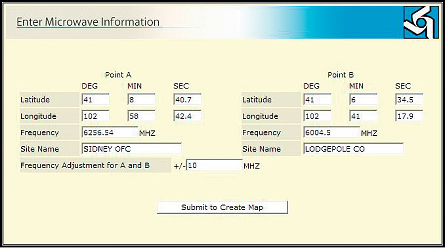
Basin Electric Power Cooperative, headquartered in Bismarck, North Dakota, is one of the largest electric generation and transmission cooperatives in the United States, generating and delivering electricity to 120 member cooperatives. These member systems then provide power and services to 2.5 million retail consumers located in nine states: Colorado, Iowa, Minnesota, Montana, Nebraska, New Mexico, North Dakota, South Dakota, and Wyoming. Basin Electric owns 2,595 megawatts (MW) and operates a total of 3,508 MW of electric generating capacity. The company owns 1,790 miles and maintains 1,867 miles of high-voltage transmission lines; it also owns and maintains equipment in 56 switchyards and substations and 85 microwave and fiber-optic installations used for communications and system protection. Its service territory spans 430,000 square miles from the Canadian to the Mexican border. Basin Electric is the parent company to seven subsidiaries and employs more than 1,800 people at its facilities. Basin Electric now uses ArcGIS Server for an enterprise GIS environment that delivers business value and improves internal processes throughout the organization. The server-based solution maximizes GIS investments by providing open access to GIS capabilities via the Web. Basin Electric employees, without any previous GIS experience or training, can access powerful digital tools via a simple, easy-to-use interface. The ArcGIS Server implementation answered Basin Electric's need to ensure that as other companies added microwave radio systems within Basin Electric's service territory, these systems would not cause radio frequency interference at any of Basin Electric's existing radio sites. Basin Electric currently operates radio systems from more than 80 radio towers to provide data and voice communications for telephone circuits, SCADA, mobile radio, system protection, and more. "The main goal is to allow employees to use the power of GIS, with minimal training, through user-defined Web applications," says Jason Brekke, GIS/mapping specialist, Basin Electric. "Anyone from a GIS specialist to an electrical engineer or an administrative assistant can complete projects using these applications. You do not need to know the Esri GIS software to complete the task. Productivity is extremely higher."
Patrick Engineering (Lisle, Illinois), an Esri Business Partner with the necessary background and skills, developed an application based on ArcGIS Server for Basin Electric and performed a user needs assessment, customized the application, and provided implementation services. In addition, Basin Electric used the Esri Developer Network (EDN) to prototype and test the new application. EDN is an annual subscription-based program that provides software developers with the resources needed to build solutions that embed Esri desktop and server technologies. The delivered application allows a large group of simultaneous users to perform queries, access resulting data, and see whether there might be an interference problem with potential new microwave radio systems. The success of the application was immediate. Engineers were able to quickly and easily perform their own analysis without submitting requests to outside departments and waiting for others to carry out the task. This gave them direct access to the data they needed and freed up GIS analysts to perform more technical, GIS-centric work for the organization. The initial success of the radio transmission application led to the deployment of a second ArcGIS Server application, also developed by Patrick Engineering. Basin Electric maintains more than 200 remote facilities located throughout its territory. To meet regulatory guidelines, the company must maintain up-to-date routing and emergency information, including routes to each facility, contact information, and the location of the nearest hospital. Much of this information was maintained in hard-copy form, including paper maps. Basin Electric migrated the previous paper-based information into ArcGIS Server to provide an automated method for better maintaining the data and for allowing easy information access to any employee throughout its nine-state service territory. Facility maps and related data, now available throughout the organization, began to be used for other business purposes, including procurement bids and land management. Basin Electric is now investigating possible future applications, including using GIS to generate map books, as well as developing a mobile asset maintenance application. More InformationFor more information, contact Jason Brekke, GIS/mapping specialist, Basin Electric Power Cooperative (e-mail: JBrekke@bepc.com). For more information about ArcGIS Server, visit www.esri.com/arcgisserver. |