Fall 2007
Fall 2007 |
|||||||
|
|
|||||||
Firefighters Benefit from Geoenabled Situational Awareness |
|||
|
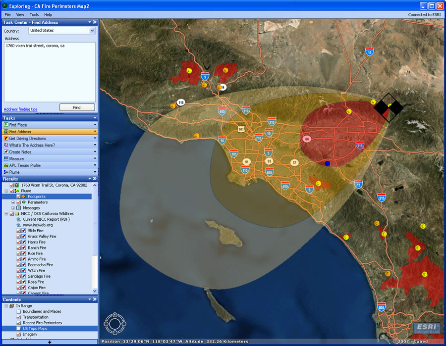
As more than a dozen wildfires raged across Southern California in October 2007, GIS professionals from numerous agencies played a paramount role in effectively responding to the fires and minimizing the loss of property and life.
"One of the great challenges is being able to coordinate all of the resources necessary to support all of the incidents occurring at one time," says Russ Johnson, public safety manager, Esri. "Crucial decisions must be made to allocate resources and deploy them where they're needed most. You must understand not only where fire perimeters currently are but also where they could go; what direction they are headed; and what lives, property, and other assets are threatened. These decisions require continuous incident mapping to understand their size, scope, and potential threat." Beginning October 19, an outbreak of severe wildfires quickly spread across Los Angeles, Orange, Riverside, San Bernardino, San Diego, and Ventura counties. After more than two weeks of devastation, 21 fires had forced more than a half million people from their homes and destroyed hundreds of thousands of acres of land and thousands of properties. A state of emergency was declared in seven counties. Yet despite the terrible calamity and destruction, the response was successful in minimizing loss of life and property given the enormity of the disaster. Courageous firefighters and other responders were ready and began battling the blazes as they broke out. Esri, having partnered with many of these agencies during the similar 2003 outbreak of wildfires in Southern California, contacted the various response organizations and began providing GIS support. "As the fires spread, we quickly called up our own disaster response team and sent staff, software, and services to multiple sites," says Johnson. "These included incident command posts, the Southern California Geographic Area Coordination Center, California state headquarters in Sacramento, and the FEMA [Federal Emergency Management Agency] joint operations center located in Pasadena, California." Preparing the Battlefield and Responding to the FiresOne of the greatest challenges to large-scale disaster response is effectively deploying resources where and when needed. The Southern California wildfire response was enormous, with massive numbers of firefighters, vehicles, and support equipment from throughout the country. Mutual aid and support came from throughout the West, and additional support was staged and ready to respond from all corners of the United States. The California National Guard assisted with 2,700 troops. The Department of Defense and the Department of the Interior also provided airborne firefighting support with P-3, U2, and unmanned aerial vehicle (UAV) aircraft supplying aerial imaging support. With all of these agencies and assets arriving in Southern California, managing the people and resources was complex. GIS was crucial in this effort. GIS technology was used continuously to integrate and map fire perimeters, view imagery, model potential fire spread, identify evacuation requirements, and forecast when and where equipment would be needed. Esri assisted daily GIS and mapping activities to support critical mission requirements. A map-based portal was established to centralize fire data and manage fresh information and dynamic event data as they were gathered. Esri assisted in the development of a prototype automated damage assessment system and established a central database in order to visualize damaged parcels throughout all the affected areas of Southern California. Esri staff also assisted in collecting field damage assessment data using the prototype mobile GIS application on handheld computer devices. Federal, state, city, and county agencies worked together using GIS to prioritize and direct manpower and resources, monitor events on the ground as they unfolded, perform predictive modeling of fire spread, and dynamically respond to ever-changing conditions. For instance, the Southern California Geographic Area Coordination Center used GIS for performing a number of logistical duties and coordinating resources. Set up in Riverside, California, the center housed representatives from federal agencies in addition to state, county, and city jurisdictions. These representatives worked together to determine equipment requirements and priorities for deployment based on field conditions. "They used GIS to look at fire perimeters, weather conditions, where fires would spread over the next several days, threatened populations, and natural resources," says Johnson. "We sent staff to assist and support the development of these types of analyses and maps. Esri staff also assisted in analysis to support long-range planning to anticipate organizing the movement of crews, their equipment, and supplies." FEMA established a disaster relief center in Pasadena, California. Esri sent a task force of people, software, and hardware to support FEMA as it fulfilled state and local government agency requests. FEMA staff used GIS to identify and implement temporary shelters for displaced families, bring in mass casualty support units, provide food resources and financial assistance, and support the firefighting efforts and recovery needs as required. At forward command centers for each fire, 2D and 3D fire perimeter maps and fire hot spot density analysis helped fire chiefs plan fire breaks, water drops, and other tactical fire suppression tasks. GIS maps were developed to support fire incident action plans by providing a visual reference to divisions of work, logistical support facilities, drop points, staging areas, helibases, and other essential facilities to support fire operations. For example, an incident management objective might be to keep the fire from crossing a designated highway so as to protect houses or critical infrastructure. Maps are used to identify critical protection priorities and determine what type of equipment and personnel are required to meet planned objectives. This also includes positioning fire crews, determining where aerial water drops may be required, and preparing potential contingency plans if primary efforts fail. In some cases, because of the fire intensity and high-gusting wind conditions, the incident commander or operations chief may determine that it is unsafe to put personnel in locations where conditions might result in dangerous exposures. In these circumstances, GIS can assist in developing alternative tactics that focus on indirect efforts, such as determining where fire breaks should be constructed and where burnout or backfire operations can be deployed. "By having GIS, you pull together in one place all of the relevant information that allows you to quickly understand the impact of the fire and what values are threatened and begin to formulate the best strategy to reduce spread and protect vital resources," says Johnson. "GIS provides an information-based picture that provides you with comprehensive situational awareness to make quick, intelligent, and safer decisions." Many Different GIS SuccessesSeveral other GIS uses helped other agencies responding to the fires. Law enforcement agencies identified threatened communities and targeted areas that would need to be evacuated. Health and aid agencies used GIS to identify populations that may have been affected by smoke or would require immediate assistance if evacuated. They analyzed multiple variables to determine the number of beds that could be needed for each site; the amount of food, water, and clothing that might be needed; and the duration for which these shelters would need to operate. The GIS Web portal provided a valuable tool for field teams. They could access image data, parcel and property data layers, and fire perimeter and progression data using mobile technologies while performing damage assessment duties. The data captured in the field could then be used to establish recovery and rehabilitation priorities, such as areas of concern where vegetation and watershed analysis presented a high risk for potential flooding that could result from rain. "The interagency response provided a central front for prioritizing and applying support for local fire response," says Johnson. "As information was collected from various incidents, it was readily exchanged and centralized using GIS as an integration platform." Public information professionals used GIS-based maps and information to answer questions about fire locations, road closures, evacuations, shelter locations, and damaged or undamaged property. Digital and paper maps were used in television and print media news articles. Esri posted daily fire maps on its Web site for the public and media and provided customized media maps based on specific requests. Esri also made available a highly intuitive, free GIS application for viewing a wealth of digital fire perimeter and related map information for the public. Users could access the application via the ArcGIS Explorer Resource Center. The California Fires application displayed fire perimeters for all the Southern California fires. ArcGIS Explorer automatically refreshed the service every 15 minutes to check for perimeter updates. "There were many, many different reasons for the successes achieved during the fire response," says Johnson. "The tremendous work of the firefighters and emergency responders and the early and direct coordination between federal, state, and local agencies were essential. And GIS professionals were there on the front lines and in the command centers, providing the informational support that aided in virtually every kind of decision being made. It was a true synergy of people moving in the same direction to help save lives and property." More InformationFor more information, contact Russ Johnson, Esri (e-mail: russ_johnson@esri.com). See also "GIS Helped Multiple Agencies Respond to Southern California Fires." |