Fall 2007
Fall 2007 |
|||||||
|
|
|||||||
GPS/GIS in American Samoa, South Pacific
Regulating Illegal Piggery Waste Runoff |
|||||||||
|
By Barbara Zennaro, Environmental Scientist, American Samoa Environmental Protection Agency Highlights
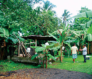
The raising of pigs in American Samoa represents an important part of the Samoan culture. Pigs are consumed during a variety of social events, from birthdays to funerals and from weddings to farewell parties. However, pigpen (piggery) waste disposal has been largely uncontrolled, resulting in volumes of untreated pig urine and feces contaminating drinking water, streams, and nearshore ocean water. The impacts of pig waste on human health and water quality are now critical, and illness and death due to pig-related disease are documented. In April 2006, the American Samoa Environmental Protection Agency (ASEPA), in an attempt to regulate this nonpoint source pollution, launched the Piggery Compliance Program. The purpose of this program is to inventory all existing piggeries, educate piggery owners on safe practices for the raising of pigs, and enforce the current regulations. The goal of the program is to legalize those piggeries that are compliant with current regulations and to relocate or remove all noncompliant piggeries that represent a threat to human and environmental health. In a country where physical addresses do not exist, GPS and GIS technologies were essential for the success of this program. The exact location of each piggery was acquired using GPS units, while information regarding each piggery was easily stored, edited, and retrieved using GIS technology. American Samoa is a U.S. territory located in the South Pacific between Hawaii and New Zealand. It is made up of five islands and two atolls with a population of 60,000 people, most of whom live along the coast of the main island, Tutuila (approximately 130 square kilometers). American Samoa's lifestyle was based on traditional customs and a subsistence economy until the 1960s, when President Kennedy made funds available to modernize the territory and jolted its people into 20th century life. The population has tripled since then, and a new issue has arisen: stream water once used for household chores is now contaminated by fecal bacteria.
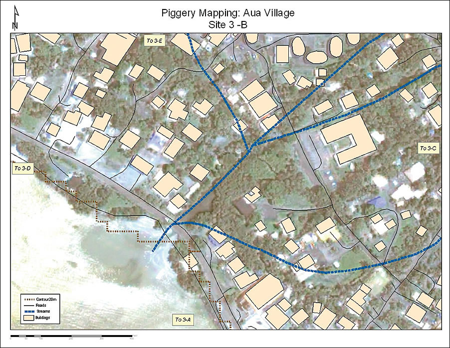
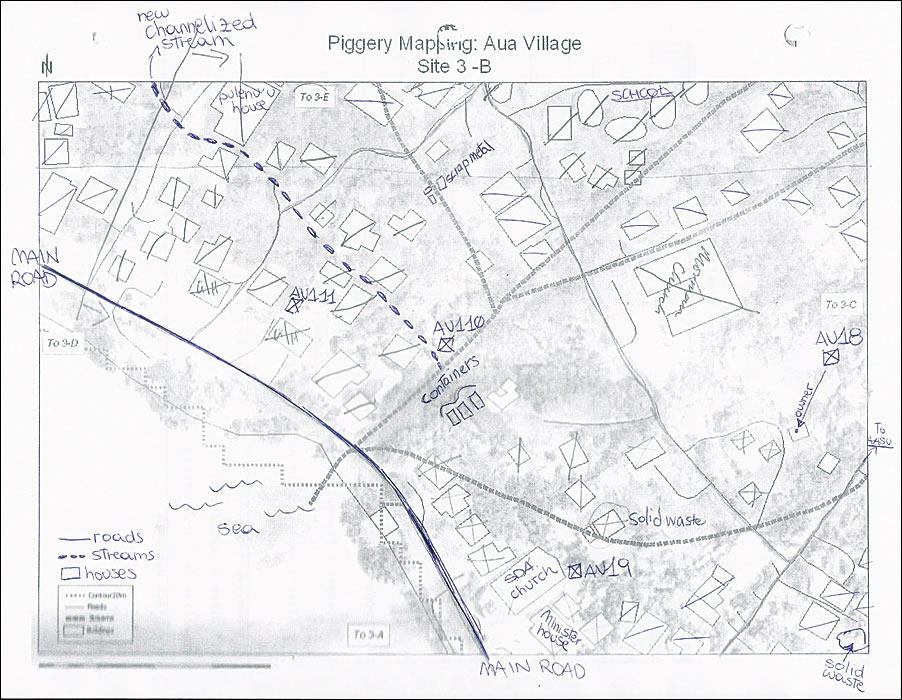
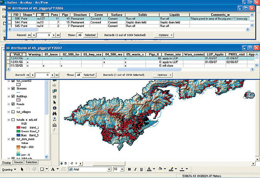
In April 2006, ASEPA personnel and volunteers from other agencies (a total of about 30 persons) were trained to use the three Trimble XP GPS units available. They visited each house and road of the territory, recording piggery and solid waste locations, educating piggery owners, and collecting piggery and owner information. ArcView was used in the two different phases of the piggery compliance program: phase 1, inventory and education, and phase 2, enforcement. Before the fieldwork, the teams were given paper maps of the area to survey, where they wrote notes on piggeries and solid waste locations and checked the visited houses one by one. This step was very important in case of GPS failure or misuse. QuickBird satellite images were also used to identify structures that did not appear in the available GIS shapefiles. Pathfinder Office software was used to create a data dictionary to assure the systematic and correct collection of the data for each piggery. It was also used at the end of each working day to download, differentially correct, and export the data into a personal geodatabase. Data was collected using TerraSync software. Editing to correct wrong locations (the point was taken at a distance from the piggery) and spelling mistakes was also done on a nearly daily basis. ASEPA surveys found approximately 8,300 pigs contained in 1,005 piggeries, of which only 3 percent were compliant with current regulations. After the inventory/education phase, spatial analysis was used to identify those piggeries that represented a major threat to human health, focusing on those located within 50 feet of streams in highly populated villages. The database was also enlarged to contain information regarding enforcement action for each piggery. The geodatabase is essential for a rapid retrieval of data, and it is used to identify and relocate piggeries after complaints and to track warnings, citations, relocation, and removal of piggeries during the enforcement phase of the program (phase 2).
The GPS/GIS approach to this project proved to be time efficient and cost-effective. Frequent and uncomplicated training of personnel by ASEPA GIS specialists allows having two to three teams always ready for fieldwork, and the easy interface of ArcView allows enforcement officials to access the database and retrieve information even without a deep understanding of GIS principles. This same approach is now being applied to the enforcement of illegal solid waste in American Samoa, and because of its straightforwardness and cost-effectiveness, it is recommended to other Pacific islands and small communities that want to locate and eradicate sources of pollution in a limited time frame and with limited financial resources. About the AuthorBarbara Zennaro is currently working as the environmental scientist/GIS specialist for the American Samoa Environmental Protection Agency. She has an M.S. degree in marine resource management with a minor in earth information science and technology from Oregon State University, United States, and a bachelor's degree in ocean science from Bangor University, North Wales, United Kingdom. More InformationFor more information, contact Barbara Zennaro (e-mail: zennarob@gmail.com). |