Fall 2007
Fall 2007 |
|||||||
|
|
|||||||
WHO Manager Steeve Ebener Unites Global Support of Human Health with GIS |
|||
|
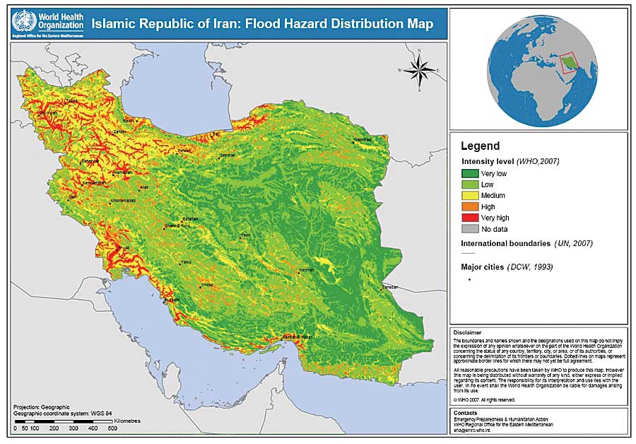
Ebener, a Swiss citizen, came across GIS in 1994 when studying geology at the University of Geneva, Switzerland. He integrated the use of GIS into his Ph.D. thesis on watershed modeling, completed in 1999. His geology background taught him to look at information both in space and over time when he began work at WHO nine years ago. As a project manager within the WHO e-health team, Ebener works tirelessly on projects contributing to the development of an international spatial data infrastructure (SDI) platform for the collection, management, analysis, visualization, and sharing of information. Although SDI is not a topic that makes headlines, Ebener is dedicated to providing a foundation for correct and shareable information that is essential for making dependable analyses and good decisions. As a result, WHO's Second Administrative Level Boundaries (SALB) dataset came into existence. According to WHO, the SALB project is a good illustration of the potentiality that exists within the United Nations (UN) and non-UN community in terms of collaboration, access to data, and technical skills. Within the United Nations, SALB represents the biggest interagency project ever realized in the field of geographic information. The SALB project started as an effort to create a GIS layer of administrative boundaries that the international community could use to collect or provide information and would allow comparative analysis of issues, such as health care delivery, disaster relief, and other WHO concerns. This layer is essential for understanding national authority and distribution networks when planning UN emergency response and program initiatives. Working closely with each nation's national mapping agency also opens communication channels, which sets the stage for cooperation when disasters strike. Such was the case in Indonesia during the May 2006 earthquake disaster when relief workers needed to share information. "Steeve is able to work with a wide variety of partners and produce high-quality products in collaboration with others," says Tony Burton, systems analyst, Department of Immunizations, Vaccines, and Biologicals, WHO. "His leadership and effort in the SALB project deserve the highest recognition." Burton worked with Ebener during the project's formative years.
Currently, information about administrative structure (and its change over time) is available for more than 150 countries and more than 50 validated maps. This data can be downloaded on a country-by-country basis from the SALB project Web site. Each country's dataset represents a unique project in which teams must obtain permissions; collect, extract, and clean information; review and validate each completed dataset; and maintain metadata about the process. As a result, communication takes place in multiple languages over disparate time zones, and boundaries may have to be redrawn quickly when political power changes hands. Under Ebener's leadership, the SALB project, in connection with other initiatives, has established a starting point for promoting the sharing of spatial information among many agencies not only internationally but also within each nation's internal agencies, which helps build an integrated National Spatial Data Infrastructure (NSDI). "The SDI concept includes all the elements that you need at each step of the process," says Ebener, "from defining the needs to disseminating and/or using information, data, or knowledge, to ensure content and technology interoperability. SDI is not only about a database structure and putting a network of computers in place but also about making sure that appropriate agreed-upon standards, protocols, and policies are put in place and connections among stakeholders are established to reduce duplication of efforts." Ebener's additional challenge is to help policy makers understand the benefits of such an approach. Including a strong geographic component in projects that measure accessibility to health care and population coverage is a central theme of Ebener's work in the field. For example, WHO is collaborating with the Zambia Ministry of Health to use GIS to support HIV/AIDS monitoring, evaluation, and response in Zambia through the establishment of an NSDI that is driven by public health needs. They use AccessMod, a GIS tool developed by Ebener's team, to analyze population coverage capacity of existing health facility networks and propose solutions to improve coverage. (AccessMod is available for download at Esri's ArcScripts Web page, arcscripts.esri.com.) "The beauty of this process is that it demonstrates that health needs can be used as the driver for establishing an NSDI," says Ebener, who is convinced that the need to solve a problem inspires and supports SDI development. "I am just the visible tip of the iceberg," says Ebener about SALB and the other projects. He credits the collaborative work of his colleagues for helping move GIS usage from thematic mapping toward a next generation of information analysis and integration. He says, "A big part of what I am doing is connecting people, which never appears on my r�sum� but is so important." This is certainly why he was recently asked to look at the importance of social networks in public health. He works in collaboration with the Philippines Ministry of Health to analyze and improve information and social networks used by doctors working in remote areas. Inspired to make the world a better place for his wife and young daughter, Ebener is convinced that people and geography play integral roles in this process. He quotes the Greek historian Polibius as saying two millennia ago, "It may have been possible in the past for things to have happened in isolation, but from this time forth, the world must be seen as an organic whole, everything affects everything." Toward this goal, Ebener concludes, "There is so much that remains to be done to take advantage of what geography and GIS have to offer." More InformationFor more information on the SALB project, visit www.who.int/whosis/database/gis/salb/ salb_home.htm. |
 This article is part of an ongoing series honoring individuals who have made a difference in the world by applying a GIS solution to challenges or needs within conservation or their communities. Since these unique individuals have been selected for their innovations or special achievements in a particular field, the series is appropriately named GIS Heroes. Esri recognizes Steeve Ebener as a GIS hero.
 Whether on the archery field or working to improve health information systems for the World Health Organization (WHO), Steeve Ebener strives for perfection. That trait makes him well suited to the difficult task of designing GIS data standards that can be adapted globally, help improve human health locally, and integrate both spatial and temporal dimensions. If his records in archery (12 national champion titles in Switzerland) are any indication, his professional endeavors will also continue to hit the mark.