Fall 2008
Fall 2008 |
|||||||
|
|
|||||||
USDA Uses GIS Web Technology for Plant Protection Program
17-State Grasshopper and Cricket Suppression Program Managed with GIS |
|||
Highlights
Protecting the nation's croplands from infestation has become a high-tech battle wherein government agencies are deploying spatial sciences to locate and monitor agricultural pests. An essential component in this campaign is GIS technology, because of its computer-based geographic tools that can access databases and dynamically display data in interactive on-screen maps. Recent advancements in Web technologies have made it possible for more people to input crop and infestation information into these databases and, in turn, generate crop management maps from them.
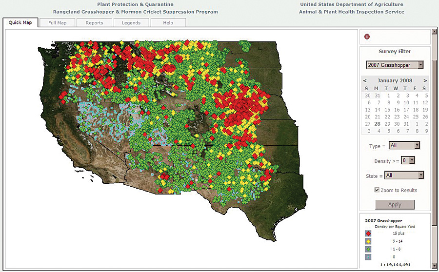
The U.S. Department of Agriculture (USDA) Animal and Plant Health Inspection Service (APHIS) has been using GIS for years to map infested areas and plan treatment programs. The relationships between features on a map communicate necessary and strategic information. Because APHIS' charge is to safeguard agricultural and natural resources from the risk of animals, plant pests, and noxious weeds, it has a lot of data and a lot of geography to consider. APHIS managers and researchers working in the agency's Plant Protection and Quarantine (PPQ) program rely on GIS to monitor pest and weed activities. Four years ago, researchers used ArcGIS Desktop software to study the effects of the emerald ash borer on ash tree populations. By layering tree data, such as tree crown measurements, aerial images taken in different seasons, and water availability, they could determine what variables were increasing the risk of ash borer tree damage. The next year, PPQ officers used their GIS to manage the impact of the Asian longhorn beetle in New York. This time, a wider variety of data layers was accessed. Using geographic information layers such as tax maps and building footprints, researchers located properties within the Asian longhorn beetle quarantine areas and created maps for scheduling survey and chemical treatment operations. These types of studies were performed with desktop GIS software, but soon USDA staff implemented GIS-enabled Web applications, making it possible for more PPQ staff to use a geographic approach to pest management. This created a change in the way the agency conducts its programs. Once APHIS began using ArcIMS, it was able to deliver data to more people. With the release of ArcGIS Server 9.1, APHIS came to another GIS milestone by introducing ArcGIS Server technology into its Rangeland Grasshopper and Mormon Cricket Suppression Program. Currently, APHIS manages 17 states affected by this infestation. The server technology opened a door for in-depth applications of geographic data. Botanists, entomologists, veterinarians, and a host of other professionals who have little knowledge of how GIS works can use such technology for research, management, policy making, and other USDA activities. These users access APHIS data via their browsers to study attribute variables and geographic relationships. Furthermore, the software allows APHIS' GIS developers to create dashboards and tools for online users that work with a variety of databases. For the Rangeland Grasshopper and Mormon Cricket Suppression Program, PPQ field agents use ArcPad for ground survey tasks. To study grasshoppers, field survey crews use handheld devices to record pest-related data and their locations. PPQ devised a digital form that works on a mobile device integrated with a GPS. The field surveyor can capture x,y location data while inputting other pest surveillance data required by the PPQ Integrated Survey Information System. The mobile tool uses a synchronization service, which aids mobile technology by managing the input of field data into the Microsoft SQL Server database. This process makes it possible to synchronize data gathered in the field to the PPQ's database over the APHIS network. More than 30,000 point locations are synced over the network during the season. SDE functionality within ArcGIS Server enables GIS to manage large amounts of the data and associated attributes and metadata so that program managers can easily get to the exact information they need for their management decision making and report outputs via the Web mapping application. The national program director for the Rangeland Grasshopper and Mormon Cricket Suppression Program in the Washington, D.C., area uses GIS-generated maps to meet demands from the U.S. Congress. The maps provide a cumulative view of infestation data by area. Data can be queried via a variety of filters, including dates, pest density, location by state, and grasshopper life stage survey information. The national program director can easily create his own map products for USDA meetings and fill congressional requests. Having the mapping capabilities at his disposal, he regularly provides updates at the Secretary of Agriculture's Drought Task Force meetings. This task force is convened to inform the secretary of activities within USDA agencies that assist growers and ranchers in drought-stricken regions. Grasshopper and Mormon cricket outbreaks can be exacerbated by drought conditions. The task force meets twice monthly, and the APHIS Rangeland Grasshopper and Mormon Cricket Suppression Program provides updates about the current status of grasshopper populations and their potential for causing economic damage to ranchers. The survey maps are the most effective way to convey a large amount of information in a short period of time. In addition, the maps are provided to congressional staff members during the annual budgeting process. Laura Stretch, the APHIS regional GIS manager for the PPQ Western Region, is enthusiastic about ArcGIS Server. "The advantage of the software is that it is enabling our field specialists, managers, and researchers to access a larger variety of data on their own. This makes it easier for them to extend their ability to manage PPQ programs. As we build on our GIS infrastructure, we can digitize and capture information about treatments and determine the most appropriate places to perform surveys. More InformationFor more information, contact Laura Stretch, PPQ regional GIS manager, USDA-APHIS (e-mail: laura.stretch@aphis.usda.gov). |