Fall 2009
Fall 2009 |
|||||||
|
|
|||||||
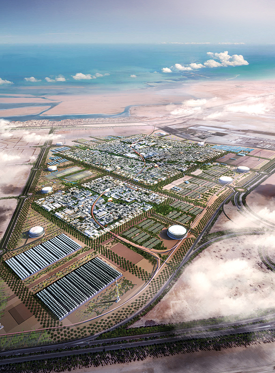
GIS Helps Ensure that Masdar City Meets Its Carbon-Neutral, Zero-Waste Goals
Building an Oasis in the Desert |
|||||
Highlights
Many of us are interested in decreasing our carbon footprint, whether one individual, one family, or one organization at a time. Imagine living in an entire city specifically designed to meet the ambitious goals of zero waste; sustainable living; and, ultimately, carbon neutrality. This is the vision of Masdar City, which is being designed and constructed in Abu Dhabi, the capital of the United Arab Emirates (UAE), by Masdar, Abu Dhabi's multifaceted initiative advancing the development, commercialization, and deployment of renewable and alternative energy technologies and solutions. Masdar, which means "the source" in Arabic, integrates the full technology life cycle—from research to commercial deployment. The Masdar company aims to create renewable energy solutions. Masdar City is a prime example of how GIS can be used to design our future. This shimmering oasis of 6 square kilometers, located 30 kilometers from Abu Dhabi city, is committed to sustainable living. To reach its carbon-neutral ambitions, Masdar City will use only renewable energy sources. A photovoltaic power plant will generate most of the electricity, while the city's cooling will be provided via concentrated solar power. The zero-waste targets of Masdar City will be achieved through a combination of recycling, reuse, and some breakthrough waste-to-energy technologies. Landscaping within the city and crops grown outside will be irrigated with gray water and treated wastewater produced by the city's water treatment plant. Through this innovative design, residents in Masdar City will consume far less energy. Peak demand at Masdar City is currently predicted to be only 200 megawatts instead of the 800 megawatts normally required by a conventional city of the same size and climate zone. Desalinated water consumption will drop from 20,000 cubic meters per day to only 8,000. And Masdar City will eliminate the need for millions of square meters of landfill. The first residents of Masdar City will be the students and faculty of the Masdar Institute of Science and Technology (MI). MI is a graduate-level university specializing in alternative energy and environmental technologies and is a collaboration between Masdar and the Massachusetts Institute of Technology. MI will ensure a ready supply of highly skilled graduates to meet the growing demand within the clean technology and sustainable energy sectors. Shifting from Oil to Renewable EnergyUAE is a federation of seven emirates, or federal states, located in the southeast Arabian Peninsula. Abu Dhabi, the capital of UAE, has a rapidly growing economy, due largely to the emirate's vast oil reserves: Abu Dhabi is estimated to hold approximately 9 percent of the world's crude oil reserves. Despite its vast hydrocarbon resources, Abu Dhabi has adopted a progressive approach to its economic growth. The emirate is committed to diversifying its economy away from oil, ensuring the long-term development and prosperity of the country. As a worldwide leader in the energy markets, the emirate believes it is well placed to invest its knowledge and financial resources in the world's future energy markets—renewable energy. So in April 2006, the Abu Dhabi government established Masdar. Through its portfolio of projects that includes carbon monetization, clean technology investments, and renewable utilities projects—both in Abu Dhabi and abroad—the company is contributing to the global effort of mitigating climate change. In this way, Masdar plays a key role in the development of Abu Dhabi's renewable energy sector, driving continual innovation and commercialization of clean and sustainable energy technologies. Masdar's progress since its development has been significant. The company has established partnerships and large-scale renewable energy programs around the world. And as a further sign of Abu Dhabi's advancement in the alternative energy space, UAE was recently successful in its bid to host the headquarters of the International Renewable Energy Association, against strong European competition, in Masdar City. CH2M HILL, an Esri Business Partner and a leader in full-service engineering and consulting based in Colorado, was chosen as a leading partner for the Masdar City design/build project. CH2M HILL had used Esri technology on many projects in the past and knew ArcGIS was the solution necessary to manage and analyze information throughout the city's life cycle. Lean, Green City Planning"GIS is imperative in managing the overall spatial information necessary for designing, building, and operating Masdar City," says Derek Gliddon, GIS manager, Property Development Unit, Masdar.
For the city to meet its challenging goals, CH2M HILL carefully considered the geography of the area: sun angles, wind patterns, street widths, and building density and height. The orientation of buildings on a diagonal grid to provide maximum natural shading was modeled in ArcGIS. To understand all the variables and communicate effectively during the project, the company used a geodatabase that enforces use of a single, shared coordinate system across the project. A common basemap was created to support planning, design, and construction of the city, with the foresight that the city would also be maintained and operated using the same data. "Building a city like this has never been done before. And GIS is proving to be an absolutely critical tool," says Shannon McElvaney, formerly information solutions consultant, CH2M HILL, now with Esri. Data layers contained in the geodatabase include information such as transportation, vegetation, drainage, structures, boundaries, elevation, biodiversity, buildings, and utilities, as well as terrain elevation, bathymetric data, and remotely sensed imagery. Information from tabular databases is incorporated into the map layers, as well as GPS coordinates and georeferenced photographs. All the construction-related information, including cost, schedule, and carbon tracking data, is tied together by location, making it more accurate and efficient to use. The resulting information is available company-wide. ArcGIS Server was recently deployed and will enable the more than 100 organizations involved in developing Masdar City to access maps, data, and analytic services, thus reducing problems of multiple data versions in circulation. A sophisticated Web browser-based virtual city visualization and navigation tool uses master plan data from the geodatabase and links to the program scheduling software. This tool is used to visualize the construction of the city over time. Construction managers can navigate anywhere in the city; "play" the project timeline; and identify spatiotemporal clashes, accessibility problems, and other logistical issues. On a fast-paced, high-density development, these issues are very important. Information can be searched using spatial criteria and viewed on easily readable thematic maps. Using GIS to visualize the massive amounts of data makes communicating about the project easier. Optimized Facility PlacementArcGIS introduced the spatial analysis and modeling necessary for the most efficient placement of facilities at the city. Water and sewage treatment plants, recycling centers, a solar farm, geothermal wells, and plantations of various tree species were placed using traditional planning principles modeled with ArcGIS. Questions—Is there enough physical space available? How much are the buildings shading each other? How much space is needed between a facility and the residents?—are modeled and the best answer chosen through GIS. McElvaney cites a problem that was quickly resolved when line work from one building was off by 30 centimeters from the previous line work. Having access to all the data and visualizing it with GIS allowed catching the mistake: "A mistake like that could be very time and cost intensive to fix during the construction stage. GIS is extremely helpful in preventing that kind of thing from happening." From Models to Real LifeGIS has ensured that the carbon-neutral status of the city translates from a concept to design. CH2M HILL used ArcGIS to even choose where to place construction materials during the building phase. Alternative scenarios for where to place building materials could be modeled so that, in the end, the company could choose the most efficient location for reducing transportation-related carbon emissions. GIS was able to model water and power usage over a period of 10 years, plotting monthly resource demand across the city like a geographic histogram. The variables appear as different heights, allowing planners to see any issues rapidly. "This exercise immediately revealed a couple of problems with the logic that had not been easy to spot in a massive spreadsheet format," says McElvaney. Changes happening during construction were tracked and recorded to monitor the effect on carbon neutrality. Masdar City has a team that keeps track of all fuel and material use and reuse during building. This team is also responsible for logging any environmental infractions. Team members found that using a GPS-enabled camera to take photos and transfer them to the GIS to document the location of an infraction allowed them to see what happened where and whether there were underlying trends, all of which contribute to managing the sustainability of the build. Innovative TransportationMasdar City will utilize breakthrough transportation technologies that revolutionize and redefine urban transport. A Personal Rapid Transit (PRT) system running on solar-charged batteries will transport residents around the city. There will be 3,000 PRT vehicles, generating 130,000 trips each day across 85 stations. A Freight Rapid Transit system will make up to 5,000 trips per day to transport the city's goods. ArcGIS was instrumental in visualizing all routes for the PRT network and testing predicted walk times between PRT stations. Transportation planners also used ArcGIS to find optimal locations for perimeter parking garages, along with effective road and rail transport routes into the city. Real estate plots were valued using routing GIS. Beyond ConstructionConventional cities of similar size create approximately 1.1 million tons of CO2 per year—80 percent from buildings and energy creation, 13 percent from waste, and 7 percent from transportation. Masdar City expects to eliminate the emissions by producing zero carbons. ArcGIS will continue to be used and integrated with a computerized maintenance management system that will include the location of all infrastructure assets; gas pipes; smart grid infrastructure; clean, gray, and black water networks; and the transportation network. Moving forward, GIS will make facilities maintenance easier and enable the tracking of resource use and reuse and the overall carbon balance of the operational city. GIS will be used in city governance, where it will form part of the city's sustainability performance feedback service, which will inform residents about their personal contribution toward overall city performance. More InformationFor more information, contact Derek Gliddon, Masdar's GIS manager (e-mail: dgliddon@masdar.ae), or Shannon McElvaney (e-mail: smcelvaney@esri.com). |