Fall 2009
Fall 2009 |
|||||||
|
|
|||||||
Celebrate GIS Day November 18, 2009 |
|||
|
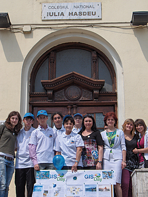
GIS Day events are held in just about every corner of the world, but another unique factor is the variety of events that are held. No event is too big or too small. To give you a little inspiration for planning your own event, here are two GIS Day celebrations that have already taken place. North Central Texas GIS Day—Collaboration Key to Successful Large-Scale EventAs the saying goes, there is strength in numbers. Four organizations pooled their resources to hold a GIS Day event that reached more than 1,000 participants of all ages. Hosted by the Geospatial Information & Technology Association, North Central Texas Council of Governments, South Central Arc User Group, and University of North Texas, the purpose of the event was to render a greater awareness of what GIS means to local citizens, municipal leaders, and business and academic communities. A variety of activities helped inspire participation, including a GIS job fair, a Geography Wheel of Knowledge game, and a student poster competition. In addition, several Dallas-Fort Worth metroplex GIS firms demonstrated their use of GIS, and a map gallery showcased more than 50 maps from local users. "The event clearly demonstrated how multiple and diverse agencies can host a successful GIS Day for a group of participants with different interests," states Robert Wachal, GIS administrator for the City of Highland Village. National College Iulia Hasdeu, Bucharest, Romania—Showing That Geography Matters to Society
Under the guidance of Professor Elena Mocean and aided by ArcGIS Desktop, a group of K�12 students was introduced to the many ways that GIS technology is used to analyze conditions and improve society. The GIS Day activities focused on three issues impacted by a growing population: wind power, potential earthquake damage, and traffic congestion. One student wanted to answer a simple question: What is the wind power potential in Romania? The students used a published map that illustrated the number of hours per year in which wind speeds were above 4 meters per second (the minimum usable speed value). They then digitized the map and combined it with a map of restricted areas (buffers of different values for cities, airports, inhabited areas, national roads, railroads, electric grids, and flooded areas). Using these datasets, it was easy for students to calculate available wind power. Another student wanted to analyze the impact a major earthquake would have on Bucharest. Using a dataset of earthquakes that took place in 2000 and data provided by the National Institute of Research and Development for Earth Physics in Bucharest, the students identified the cities that could be damaged by an earthquake. Another student studied the impact on buildings in Bucharest if an earthquake of magnitude 6 or higher on the Richter scale were to occur. They found that 122 buildings housing more than 2,000 residents would have a significant chance of structural failure. Mocean took the students' findings a step further and used GIS to make an interactive map of all the seismically challenged buildings and the shortest route to the closest hospital or school that could be used as temporary housing for the survivors. Traffic congestion is a major issue in Bucharest, the capital and largest city of Romania. Using some of the ArcGIS Desktop applications, students created routes designed to go around the city's most crowded areas. The map was digitized and the street network created, streets were adequately marked, then the route was created using the ArcGIS Network Analyst toolset. Resources AboundNeed more inspiration and ideas? Visit www.gisday.com to read other success stories, download activities and free materials, register your event, or ask us a question. No matter what the scale of your GIS Day event, it is just as important as any other and will make an impact. Join the GIS Day DiscussionThere are several ways to connect with others who are hosting GIS Day events this year:
|