Fall 2009
Fall 2009 |
|||||||
|
|
|||||||
Pennsylvania Federated GIS Enables Data Sharing Across County Lines |
|||||
Highlights
Disasters do not respect political boundaries. Emergencies, natural and man-made, often impact a broad community. It's common for emergency response support to pour in from an even wider region, from neighboring counties; cities; and, in extreme cases, from other states.
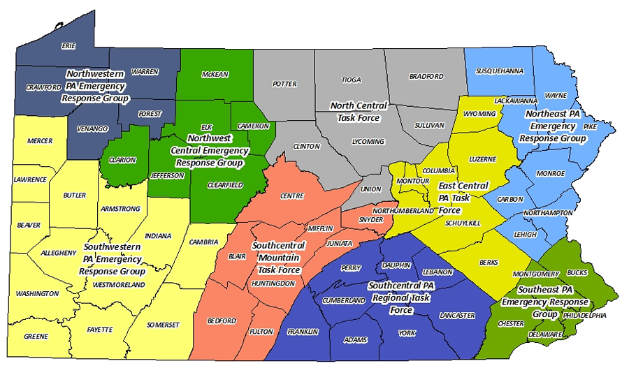
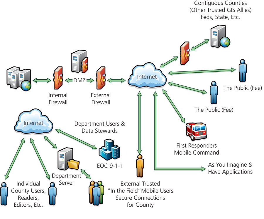
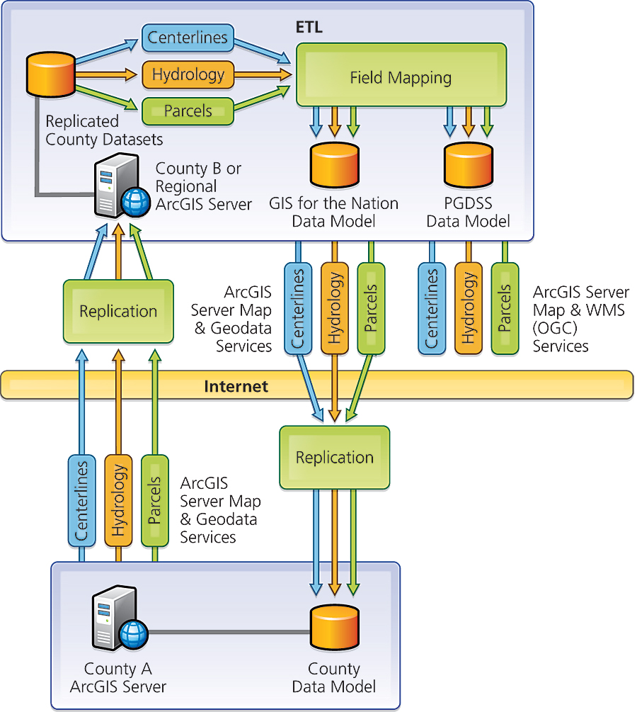
In Pennsylvania, the state's 67 counties are grouped into nine counterterrorism task forces for improved emergency management. Though the task forces were created in the wake of the 9/11 attacks on the United States, they serve not only to strengthen homeland security coordination but also to facilitate quick responses to natural events, such as flooding. For years, counties in the state have realized the importance of sharing geographic data for enhanced emergency response and have looked for ways to orchestrate it. Sharing GIS data would also provide backups to a county should its infrastructure become compromised during an emergency. Additionally, a county could use the data of neighboring counties in daily activities. Though many counties use the same ArcGIS platform, they maintain data in varied formats according to different business requirements, which historically created data-sharing barriers. When ArcGIS 9.2 was released at the end of 2006, product enhancements made data sharing easier. With geodatabase replication and the ArcGIS Data Interoperability extension that came out with ArcGIS 9.2, three counties in Pennsylvania—Clinton, Lycoming, and Union�began to look at how they could share locally maintained GIS data, such as road centerlines and tax parcels. The remaining four counties—Bradford, Potter, Sullivan, and Tioga—in the North Central Counter-Terrorism Task Force joined the effort as did Centre, Luzerne, Wayne, and Mifflin. The Pennsylvania Federated GIS pilot project was under way, with the Pennsylvania GIS Consortium offering funding and guidance. Creating a Resilient Federated GISA federated GIS is based on a distributed collection of connected GIS nodes that share and use each other's geographic information and services. In this case, a county's enterprise geodatabase serves as a node. ArcGIS Server 9.2 enabled this architecture with replication, which allows copies of a geodatabase to be distributed to other counties' GIS based on an agreed-upon schedule that could be monthly, daily, or more frequently. During a crisis, updates can be made in near real time. The Pennsylvania Federated GIS was designed to be resilient: if one county's GIS data becomes inaccessible in a crisis, it is still accessible at other locations in the state. Other servers in this connected group could immediately stand in for a disconnected node. From a remote location, the disconnected county's replicated data will run seamlessly in GIS applications. To achieve this resilience, the Pennsylvania Federated GIS is decentralized. A central server would make participating counties depend on one county, or one physical location. In the event of an emergency that debilitated the central server, there wouldn't be a backup.
Maintaining the independence of each county was also a top priority. Each county had its own workflows and data formats, which the Pennsylvania Federated GIS respects. "Part of what made this project unique was it was born in an environment where the project planners believed that county independence was nonnegotiable, and that the ability to regionally coordinate was nonnegotiable," says Thomas O. Sweet, Jr., chief operating officer of the Pennsylvania GIS Consortium. "Everything else revolved around the question, How do we make it go?" Collaboration among all participants was critical. The ArcGIS Data Interoperability extension was essential in supporting each county's individuality. The extension eliminates barriers for data sharing since it reads more than 75 spatial data formats and can export to more than 50 spatial data formats. Participating counties have direct data access, as well as transformation and export capabilities, so they can integrate various data types into their GIS. The ArcGIS Data Interoperability extension allows the counties in the pilot to process their data and load it into the GIS for the Nation data model or other unique standards, like the Pennsylvania Geospatial Data Sharing Standard (PGDSS), depending on each county's preference. This is typically referred to as an extract, transform, and load process, which creates a seamless data layer. The GIS for the Nation data model is a data-sharing information model for local, state, tribal, and other national data themes. PGDSS is a standard born out of Pennsylvania's need to facilitate data sharing among the commonwealth's various organizations; it focuses on unique attributes of Pennsylvania. Replicating SuccessThe public demonstration of the pilot took place in 2007 at Union County's Emergency Operations Center (EOC). Representatives from multiple counties, the Commonwealth of Pennsylvania, and various federal agencies attended. For the pilot, two servers that represented a county were brought online at the Pennsylvania GIS Consortium office to represent a primary task force server. The presenters were running flood models and conducting GIS analysis that is typical during an emergency when the connection to the primary task force server was severed, simulating an EOC becoming disconnected. Without interruption, the Web-based GIS application accessed data from a secondary server on the federated GIS network, and the demonstration continued without interruption. After the pilot counties successfully executed their project, the counties in the East Central Counter-Terrorism Task Force began to replicate their GIS data based on the Pennsylvania Federated GIS model. Since the federated GIS is based on out-of-the-box solutions from ArcGIS Server, new counties can join the effort without having to learn custom data models from other counties or continuously change their data into a standard format. All the participants can work off the same ArcGIS Server foundation and the same standard data models. The East Central Task Force added to the pilot's scope with a custom geoprocessing task and a mobile application that will support EOC operations during an emergency. The geoprocessing task is a road closure tool that will improve road closure management across multiple counties in the task force area during floods. Road closure information was previously collected by a number of organizations that often shared the data via fax.
The task force will deploy the geoprocessing tool in three ways. EOC workers can input road closures through ArcGIS Explorer. Local municipalities can input road closure information via a Web mapping application; the data is then part of the county's data repository and can be shared throughout the federated GIS. And the road closure data will be published as a Web service for other partners, such as commonwealth or federal agencies, to consume. Counties can choose to share this data with anyone who has access to the freely downloadable ArcGIS Explorer. The East Central Task Force's mobile application will be used to collect postdisaster damage assessment information. Via laptop computers, county assessment teams will collect data in the field and sync those updates to their county's server. Then that data can be replicated to other counties in the state. All counties in the East Central Task Force will use this custom application, and counties outside this task force can also choose to implement the application. Since the collected data will be shared in the same manner as the basemapping data, this application will assist in creating a regional damage assessment. The next counties to join the federated GIS effort are in the Northeast Emergency Response Group. Through the federated GIS project, the counties of Pennsylvania are adopting the most up-to-date GIS software and practices to allow ultimate flexibility in emergency response. Interoperability is often the greatest challenge to overcome when outside help is needed, but leveraging local data and workflow processes gives these counties the ability to expertly coordinate regional responses while honoring individual data maintenance processes built around existing business requirements and systems. More InformationFor more information, contact Thomas O. Sweet, Jr., chief operating officer, Pennsylvania GIS Consortium (tel.: 570-966-6826; e-mail: tsweet@pagis.org). |