Fall 2009
Fall 2009 |
|||||||
|
|
|||||||
|
A column from Members of the Urban and Regional Information Systems Association Mecklenburg County, North Carolina, GIS The Integrated Land Office |
|
|
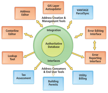
By Todd Wilson, GIS Technology Solutions Manager, Mecklenburg County, North Carolina In Mecklenburg County, North Carolina, GIS stands for Geospatial Information Services, with an emphasis on services. Mecklenburg County GIS has long provided its citizens and business consumers with a rich amount of land development datasets and property record information in the form of electronic maps and reports via the Internet to meet their various business needs. Comprising most of the area and population of Mecklenburg County, the county seat of Charlotte is the second largest banking center in the United States. The county and its "Queen City," as Charlotte is called, collaborate to provide police, fire, emergency medical, and utilities services to residents as well. Electronic tax maps, owner information, and tax values, along with real property sales analysis tools, fuel the intelligent decision making that supports Mecklenburg County's impressive growth. As Mecklenburg County's footprint increases with respect to land, residential, and commercial development, so does the workload of the Mecklenburg County GIS Land Records Office. Mecklenburg County's population grew by 19 percent from 2000 to 2006, per U.S. Census Bureau figures. According to Garrett Alexander, the county's director of property assessment, "We're about 350,000 parcels large, handling about 40,000 sales annually, as well as handling probably 50,000 or so building permits. Not all are direct new construction. If you build a 40-story high-rise, it generates a lot of permits." To address the demanding requirements of land records and addressing management, Mecklenburg County GIS continues to leverage and expand on its Esri technology, including ArcGIS Desktop, ArcGIS Server, ArcIMS, and the geodatabase. Because roughly 80 percent of the services that Mecklenburg County provides touch on a geographic location, this technology forms the integration backbone for enterprise-wide information sharing. GIS Consolidation Creates Improved EfficienciesBack in 2005, the county's GIS program was reviewed by an executive task force made up of selected executive county management and various county department directors and managers. At that time, GIS services were decentralized, performed within two different county departments (Information Services & Technology and the Land Use and Environmental Services Agency—Property Assessment and Land Records Management), and located in three separate work areas and buildings. After a program review, a recommendation was made from the county executive task force and given to the county's senior management team to centralize GIS services and position them within a self-directed service group to better serve all county departments, as well as the citizens of Mecklenburg County. The recommendation was approved.
It was this consolidation that improved GIS business efficiencies. It also brought together two disparate but complementary GIS workgroups (property mapping and address management), once located in two separate buildings, under one roof and in one work area. Later, the GIS Technology Solutions Group (formerly under the Information Services & Technology Department) was relocated into the same work area with the rest of the GIS Service Group. Today, GIS database management, property mapping, address management, and GIS application development and support are centralized in a way that provides a better service-oriented GIS program. New GIS Technology, New ProcessesAs new GIS technologies have become more readily available, they have been aggressively looked at by the GIS Service Group. The GIS Service Group's land records team generates much of the core data that powers the group's system. Everything else—data distribution, custom mapping, application development—pulls from the team's data. Upstream from the GIS Land Records Office is the Register of Deeds Office; downstream is the Tax Assessor's Office. GIS Land Records uses two software tools that significantly streamline the flow of information—ParcelSync and AddressOne from Farragut Systems, an Esri Business Partner in Lafayette, Colorado. ParcelSync, Mecklenburg County's new parcel editing system, allows an editor to simultaneously edit both GIS parcels and computer-aided mass appraisal (CAMA) data and to update the two databases in tandem. In addition to integration with CAMA systems, it may be integrated with records management systems to provide property mapping staff with access to source documents and to leverage document metadata to populate CAMA system attributes. Mecklenburg County is also integrating its parcel editing system that manages land records within the county's Register of Deeds Office. As stated by Kurt Olmsted, the county's GIS director, "Data that comes from the Register of Deeds system will be inherited directly into the Attributor form and pushed on to the CAMA system, so we don't have to rekey the data." The new addressing management tools of AddressOne meld mapping technology and database technology in a single application, allowing users to track and manage addresses enterprise-wide. It provides an ArcGIS Desktop extension that allows the creation and management of the relationship of addresses to geography. The Land Records and Addressing division of the GIS group previously existed as two separate departments that handled addressing, centerline maintenance, and parcel mapping. When asked whether it was worthwhile to bring the groups together, GIS Land Records manager Rhonda Buckner says, "It was a challenge. There was a lot of redundancy in data maintenance. And there still is. That's what this technology is helping us with. But having all the functions together in the same group means there's a lot more synchronization. We're able to get all the pieces of the data done in a timelier, more efficient manner, because we're just sitting across the way from someone who's maintaining another piece of the puzzle. If there are questions—if something doesn't look right or isn't matching up—it's as simple as getting up and walking 10 feet to the neighbor's cubicle and saying, �Look at this with me,' and getting it fixed right." This streamlining disperses the data to the appropriate points in various systems. This eliminates redundant data entry and increases the accuracy and consistency of address data enterprise-wide. The county's addressing staff is now able to effectively create new and maintain street centerline line segments, including address ranges and address points, within one ArcGIS Desktop editing interface. An addressing database browser is also available to consumers. Built on top of ArcIMS, this interface gives addressing staff and exclusive external consumers the means to query, attach mailing addresses to physical addresses, and validate physical addresses stored within the addressing database. Enterprise Addressing Technology Framework and Data ModelMecklenburg County's GIS Land Records has for a long time maintained an enterprise master address database used by many county and city consumers through different external systems ranging from permitting systems and customer service systems to utility billing systems. Any system referencing an address back to a particular service is an ideal candidate for use of a master address database. Mecklenburg County's investment in enterprise addressing takes address management to another level by providing extended addressing services and enhanced information to its consumers. A new Addressing Authoritative Database is the core piece of the framework. The Addressing Data Model comprises physical addresses within Mecklenburg County. The data model also provides mailing addresses (in state and out of state) to be linked to physical addresses. Addressing data is stored in both United States Postal Service (USPS)-accepted formats and municipality-specific formats to retain existing legacy system addressing support at the local city/county jurisdiction levels. The system also provides a common set of Web service interfaces that can be utilized by any application or system requiring real-time access to an enterprise addressing database to draw from for external data population and validation. As an additional plug-in, real-time Coding Accuracy Support System (CASS) certification Web services with USPS current addresses are also available and can be used to validate against both physical and mailing addresses entered into the Addressing Authoritative Database. Address management and consumer tools comprise the outermost perimeter of the Addressing Authoritative Database, providing interactive tools for both editors and consumers of the database. About the AuthorTodd Wilson, GISP, has 12 years of GIS software experience in application development and database management and 5 years of managing a GIS Application Development Group. He has presented at both local and national conferences, such as national URISA and the Esri International User Conference. More InformationFor more information, contact Rhonda Buckner, GIS Land Records and Addressing Office manager (e-mail: Rhonda.Buckner@MecklenburgCountync.gov), or Todd Wilson, GIS Technology Solutions manager (e-mail: Todd.Wilson@MecklenburgCountync.gov). For information about ParcelSync and AddressOne from Farragut Systems, visit www.farragut.com. |