 |
California and the Equator! Don't You Just Love Esri T-Shirts?
|
Zahid S. Chaudhry

Zahid S. Chaudhry of the West Virginia Department of Environmental Protection stopped at Joshua Tree National Park, California, during his trip to Palm Springs for the 2009 Esri Developer Summit. He also visited the San Andreas Fault and wore his Esri T-shirt! |
|
Lynn Carlson
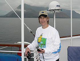
Lynn Carlson, GISP, GIS manager at Brown University in Providence, Rhode Island, is wearing her Northeast Arc Users Group T-shirt while crossing the equator aboard the National Geographic Polaris, off the northwest coast of Isla Isabela, Galapagos, Ecuador. |
|Online Only Photos|
Add Colombia, Hawaii, and Venezuela to the Mix!
 Freddy Delgado Freddy Delgado
 |
|
Freddy Delgado, engineering technician, Hillsborough County, Florida, recently visited his family in Colombia, South America. Here he is pictured with Ximena Astudillo-Delgado of the Communications Department, Universidad Javeriana, Cali, Colombia. He tells us, "Everyone in the university knows something about GIS (SIG in Spanish)." It was good of them to share their Esri T-shirt and bag. |
Sarah Schrader
 |
|
Sarah Schrader, GIS specialist for Goodhue County, Minnesota, is pictured in front of Hanakapi'ai Falls in Kauai, Hawaii. Reaching these amazing falls requires a strenuous four-mile hike along the stunning NaPali Coast on the north shore. Once there, Sarah cooled down in the frigid waters of the falls and then put on her GIS Day T-shirt (okay, it's not exactly an Esri T-shirt, but we won't split hairs because this image is so cool) for the four-mile return hike! |
Mike Clark
 |
|
Mike Clark, GIS administrator for First American Flood Data Services of Austin, Texas, is standing at the top of the world's tallest mountain . . . Mauna Kea on the Big Island of Hawaii—that is, if you measure its height from the seafloor, more than 33,000 feet. It was his honeymoon and he remembered his Esri T-shirt! |
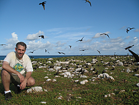
Rodrigo Lazo
 |
|
Rodrigo Lazo, GIS specialist for IVIC, Caracas, Venezuela, is wearing his Esri T-shirt on Aves Island, the most remote and northern island of Venezuela, located 500 km north of continental Venezuela and 200 km southwest from the island of Montserrat. His purpose for being there was to study green turtles (Chelonia mydas) and seabirds (Brown Noddy and Sooty Tern). He says, "I couldn't forget my old Esri T-shirt for this special expedition." |
Wear an Esri T-shirt in a unique location and send a photograph to ArcNews. Photos will be considered for use in ArcNews, the expanded T-shirt section at ArcNews Online, or both. While digital photos sent via e-mail (tmiller@esri.com) are preferred, prints or slides can be sent to Thomas K. Miller, ArcNews Editor, ArcNews T-Shirt Feature, Esri, 380 New York Street, Redlands, California 92373-8100 USA.
|