Fall 2009
Fall 2009 |
|||||||
|
|
|||||||
VIPER: Virginia Deploys Web-Based Emergency Management System |
|||||
Highlights
"What we needed was a method to avoid redundant work and to improve our situational awareness," says Bobbie Atristain, chief technology officer, Virginia Department of Emergency Management. "VIPER achieves this. Now we get the right information we need as soon as it's available to make better decisions." VDEM implemented VIPER after an extensive needs assessment. The agency wanted to overhaul its existing situational awareness system. The goal of the new system was to enhance information sharing, communication, and analysis. It would provide a new level of connectivity and fully integrate multiple systems. The obstacle of wading through numerous information stores, databases, and other technologies would be removed. In addition, preconfigured processes could be put in place so that when an incident occurs, the right datasets and feeds will be activated so that responders can act immediately and monitor events in real time. Making a Good System BetterThe Commonwealth of Virginia has a long track record of successful GIS deployments. VDEM had used GIS for years. After an outbreak of nearly 80 wildfires in Virginia in February 2008, VDEM looked at ways to improve its ability to capture data and view it in real time.
Based on a demonstration provided by Esri, VDEM contracted with Professional Services consultants in the Esri Charlotte office to help Atristain extend the capabilities of VIPER. Professional Services staff worked with Atristain to configure Esri's Flex Viewer, powered by ArcGIS Server, to monitor environmental sensors and gather data from VDEM's crisis management system and other systems, such as the National Weather Service. The system was built using ArcGIS 9.3, including ArcGIS Server and ArcGIS Desktop software. "I saw the first version of the Flex API and instantly knew that's what we needed," says Atristain. "I just thought that the Web was a much easier way for us to deploy something, because everyone can get to it—it didn't rely on any software on anyone's machine." Bolstering the High-Tech Landscape of Emergency ManagementVIPER has literally changed how VDEM provides emergency mitigation and response services. VIPER provides Virginia Emergency Operations Center (VEOC) staff with the ability to visually assess statewide emergency management operations in real time. It also automatically offers instant access to essential information and maps. For example, if a particular highway experiences a severe traffic accident with multiple injuries, VIPER will provide information about nearby hospitals; in the case of a hazardous materials spill, VIPER will offer data about schools and other high-priority evacuation sites. VIPER then performs an analysis of all available information and alerts VEOC staff about potential impacts on critical infrastructure. VIPER is set up using geoprocessing models to show staff what they want to know as soon as it requires attention—sensors about to reach action stage, at action stage, or above action stage. Then the system immediately pulls in preidentified information from multiple data points. The system alerts staff with what to look for based on a specific type of event, its location, and other factors.
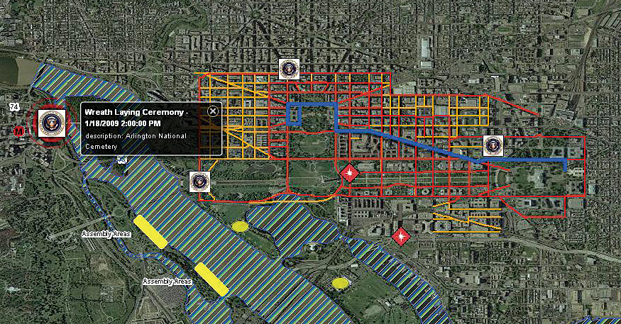
Today, VIPER is available not only to local, state, and federal agencies but also to the public (cop.vdem.virginia.gov/viper). Anyone can go online using the Web to view the real-time data and point or click their way to information they want. Street, satellite, and topographic maps provide a diverse set of basemap data. Feeds from multiple sources supply information related to air incidents, traffic accidents, civil disturbances, earthquakes, floods, terrorist threats, hazardous material spills, hurricanes, reported public health concerns (such as swine flu), power outages, reported suspicious activities, wildfires, and more. Since its launch, VIPER has had several successful deployments. During Tropical Storm Hanna, VDEM used the new platform for the first time. The system showed shelter status overlaid with the National Weather Service's feeds. This helped staff prepare in advance for the potential large-scale displacement of people. During the 2008 presidential election, VDEM staff hosted geoprocessing models authored on its desktops and pushed them into its server environment. The result was a model that queried the statewide hazmat, 5-1-1 transportation and traffic telephone hotline, and Virginia Department of Transportation construction projects against the schools and election polling location layers. During the election, staff working in the VEOC viewed only polling places or schools that fell within a two-mile buffer zone of any obstructions. The benefit was that watch commanders could immediately identify polling places that could have potential complications. They could then contact the staff at highlighted polling locations, such as near a hazardous material spill or large traffic accident, to make sure the polling process was still running smoothly. "There was a great concern about overcrowding at the polls," says Atristain. "This is why we needed the overall situational awareness for the entire state in preparation for the November election. We needed to be able to respond to something, if possible, before it became a serious problem." In addition, VIPER was used during President Barack Obama's inauguration ceremony, which was the largest in the nation's history. The system helped provide security for the 2.7 million people who attended. VIPER helped track multiple related events across Maryland, the District of Columbia, and Virginia. In the Multi Agency Command Center (MACC), local, state, and federal officials used VIPER to look for any anomaly that could have impacted the inauguration. "The system is very empowering to the end users and very helpful to the IT staff," emphasizes Atristain. "Since we implemented VIPER, our GIS department has not needed to make maps for operational incidents. Much of the information previously spread out over servers and shapefiles and different types of file formats—information GIS staff would have to work to locate during different exercises or events—is right here, on your Web browser for you." Indeed, the success of the system is catching the attention of the nation. Several local and state agencies have looked at the VIPER system as a model for something they can quickly build using their existing GIS resources and at a nominal cost. There have been congressional hearings where VIPER has been showcased as a model for a possible nationwide system. "We're getting an amazing response, especially for all the system can do that's above what you might usually see," says Atristain. "It's exciting." More InformationTo view VIPER, visit cop.vdem.virginia.gov/viper. For more information, contact Bobbie Atristain, chief technology officer, Virginia Department of Emergency Management (e-mail: Bobbie.Atristain@vdem.virginia.gov). |