ArcNews Online
Fall 2010
[an error occurred while processing this directive]ArcGIS for INSPIRE: A Collaborative Geospatial Information-Sharing Solution for the European Union
The Infrastructure for Spatial Information in Europe (INSPIRE) is chartered by a European Union (EU) directive and is intended to give EU member states the ability to share geographic information through an Internet-accessible infrastructure. INSPIRE will act as a foundation for producing, sharing, and consuming geospatial information, improving decision making and operations with respect to issues affecting Europe as a whole.
The need to collaborate and share data across national boundaries has driven the European Union to implement the Infrastructure for Spatial Information in Europe (INSPIRE) initiative. ArcGIS for INSPIRE is designed to simplify that collaboration.
For European countries and organizations that need to implement this infrastructure, Esri has created ArcGIS for INSPIRE, a solution that supports the evolution from existing geospatial solutions to a fully operational, INSPIRE-compliant spatial data infrastructure (SDI). ArcGIS for INSPIRE provides a comprehensive, integrated technology base that ensures successful participation in the EU geospatial information-sharing community and takes out the complexity of implementing an SDI.
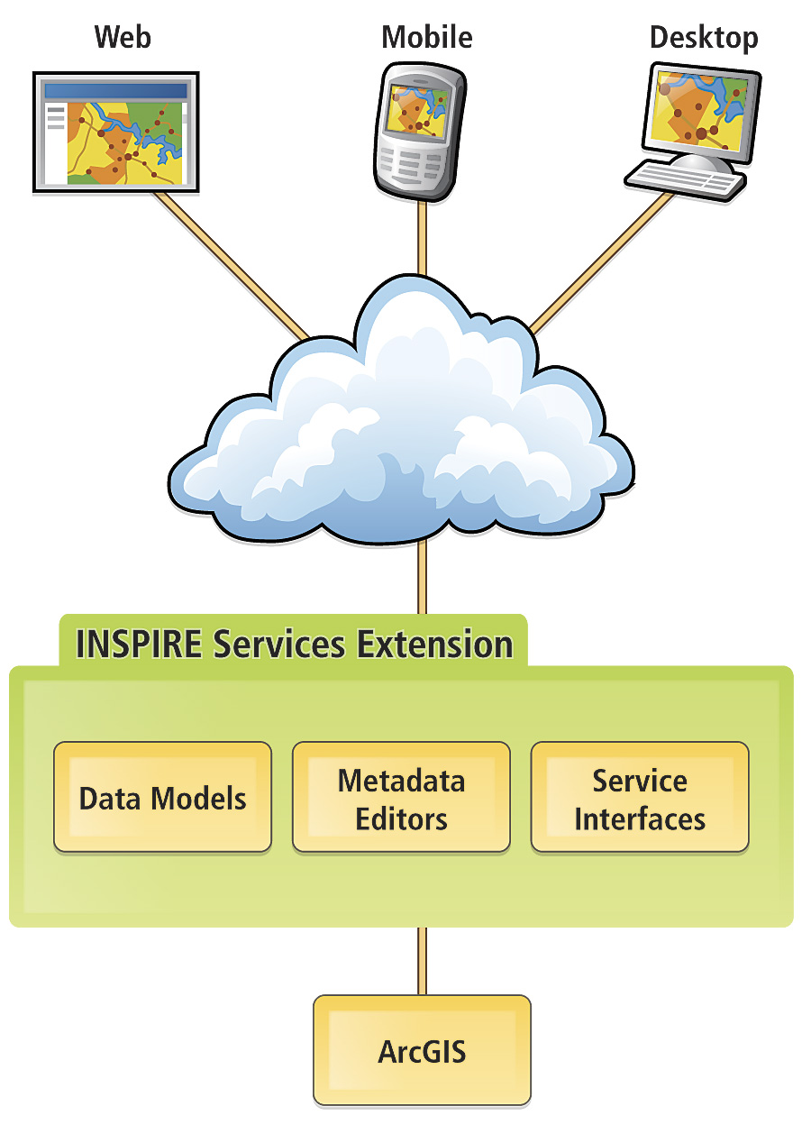
With ArcGIS for INSPIRE, Esri is providing a complete solution for an SDI in Europe. The solution is extensible and supports the needs of both INSPIRE data and service providers, as well as consumers, allowing them to
- Manage, publish, and discover INSPIRE-compliant data and metadata, as well as transform existing data to conform to INSPIRE initiatives.
- Provide INSPIRE-compliant view and download services.
- Consume geospatial data and services that comply with INSPIRE directives.
ArcGIS for INSPIRE is an extension to the ArcGIS system. The solution includes the ArcGIS Server Geoportal extension, which allows organizations to manage and publish metadata for their geospatial resources. The Geoportal extension not only supports standards-based clearinghouse and metadata/service directory applications but is now also open source. This continues the software's evolution to support users who need integration with various content management systems, map viewers, and other software.
Users can license ArcGIS for INSPIRE to supplement their existing ArcGIS implementation or begin creation of their own SDIs by implementing an ArcGIS system, being assured that their software is both INSPIRE compliant and compatible with open source solutions they may already use. ArcGIS for INSPIRE has been developed based on experience gained during the implementation of the SDI in a number of European countries, including Portugal, Lithuania, and Croatia.
Portugal—Early Adopter of SDI and INSPIRE
Portugal is an example of a country that adopted an SDI early on and is now offering INSPIRE-compliant data and services throughout the country. Established 18 years ago through Decree-Law, Sistema Nacional de Informa��o Geogr�fica (SNIG), Portugal's national geographic information system, was the first national SDI in Europe and is maintained by the Instituto Geogr�fico Portugu�s (IGP). SNIG has helped shift GIS implementation in the country to more collaborative production and dissemination of geographic information using the Internet, user groups, and mobile technologies.
SNIG is the tool used to discover, understand, and explore the geographic wealth in Portugal. This is accomplished through a geocommunity that serves as a meeting point for users to exchange knowledge through a forum, entrances created for specific thematic data networks, and provision of education about SNIG. Through this geocommunity, users collaborate and exchange ideas and knowledge about geographic information. The Official Administrative Boundaries Map, a fire risk assessment map, and a set of maps produced for the Atlas of Portugal are a few examples of the Web services used by the geocommunity.
SNIG is one of the first SDIs to have a fully operational portal and is built on ArcGIS Server and the ArcGIS Server Geoportal extension.
SDI in Portugal today means that GIS is more than simple land representation through cartography; it is important to collect, organize, store, retrieve, and explore spatial data to create action. "We understand that more important than having data repositories, we must have dynamic information flowing through the channels," says Professor Doctor Rui Pedro Juliao, the deputy director-general for IGP.
Lithuania Connects Data Providers into a United National SDI
The Lithuanian Geographic Information Infrastructure (LGII) was created to connect major national spatial information providers to a spatial information infrastructure. LGII is an open, shared National Spatial Data Infrastructure (NSDI) for accessing and distributing geographic information products and services online. The solution connects major public-sector information sources through a single Internet portal (www.geoportal.lt) that was launched in 2009.
HNIT-BALTIC, UAB, Esri's Lithuanian distributor, worked with German firm con terra GmbH to create a system to effectively manage, integrate, and manipulate the multitude of diverse data layers and create a user-friendly, front-end Web portal to view and distribute the data. The system—based on ArcGIS Server, including the ArcGIS Server Geoportal extension; IBM's WebSphere; and FME, a spatial extraction, transformation, and loading (ETL) solution from Safe Software Inc.—provides the ability to translate, transform, integrate, and distribute spatial data so users can continue to work in their native GIS formats.
Data providers include 10 Lithuanian government institutions and enterprises that are connected by a centralized national metadata system and the federal geographic data system, which are based on a uniform reference data model and standards. Both systems conform to INSPIRE initiatives.
Users can access the LGII portal anytime to discover data offerings and acquire whatever specific dataset they may need for their business tasks. Once in the system, the user simply selects the desired area from a map view, chooses the data layers required, and specifies the particular GIS output parameters by selecting from 18 different data formats and 10 coordinate systems.
"People in Lithuania have newfound knowledge now, and that knowledge is power," says Mindaugas Pazemys, deputy director, GIS-Centras. "Rather than being consumed by trying to find data, public and private users can now focus on how to capitalize on that data and develop revenue-generating applications or services. That's working smarter and ultimately leads to economic growth."
In Croatia, Simplifying Access Leads to Growth
The Republic of Croatia has simplified access to countrywide geographic data through an online geoportal, a type of Web site that makes it easier for citizens, government, and private-sector users to find and access vast quantities of geographic information and related services. The geoportal has already proved its value as an essential component of the country's Organized Land Project, which streamlines and regulates the real property registration of land in the republic. By making data more accessible, the average time for processing changes to land titles has dropped from a 400-day average to 37 days.
The geoportal is hosted by the State Geodetic Authority (SGA) of Croatia and can be found at www.geo-portal.hr/Portal. Dr. Zeljko Bacic, head of SGA, states, "Simple access to geospatial data is the key prerequisite for an efficient and economically prosperous society. The geoportal in active operation means that other governmental organizations can [not only] use SGA data but also make their data accessible. This is the first step to establishing a Croatian national geoportal as part of a national SDI."
Modeled after the INSPIRE directive, SGA is able to support the discovery and purchase of national data through the geoportal while also providing strict access control and data quality policies. Data available through the geoportal includes digital orthophotos, basemaps, administrative units, and land survey information.
The geoportal was developed by Esri distributor GISDATA d.o.o. and con terra GmbH using Esri's ArcGIS Server Geoportal extension. The Geoportal extension provides the platform for organizations to quickly access geospatial resources regardless of location or type.
"The implementation of this portal is enabling a change in behavior from a restrictive data policy to a more open, transparent, and efficient use of spatial information," says Andrej Loncaric, director of GISDATA in Croatia and the southeastern region of Europe.
More Information
For more information on ArcGIS for INSPIRE, visit www.esri.com/sdi-in-europe.html.
See also "INSPIRE Geoportals Bridge Producers and Consumers."
Related Podcast
Esri Supports INSPIRE
Guenther Pichler, Esri Business Development Manager for European Union-related issues, discusses how Esri technology helps European nation-states comply with INSPIRE directives. Listen to the podcast. [10:00 | 9 MB]