ArcNews Online
Fall 2010
[an error occurred while processing this directive]Largest U.S. Health Care System Links Staff and Resources
Highlights
- The mapping portal leverages new technologies.
- GIS analysts can activate a cached layer that identifies drive-time service areas.
- Portal provides direct access to information, freeing GIS analysts to meet other demands.
The Veterans Health Administration (VHA) operates the United States' largest integrated health care system, public or private, with 1,100 facilities serving 8.5 million enrolled veteran beneficiaries. The system is divided into 21 service regions, which in turn are divided into 80 market areas, 103 submarkets, and 508 sectors. Access by distance to VHA health care facilities is monitored at all these levels.
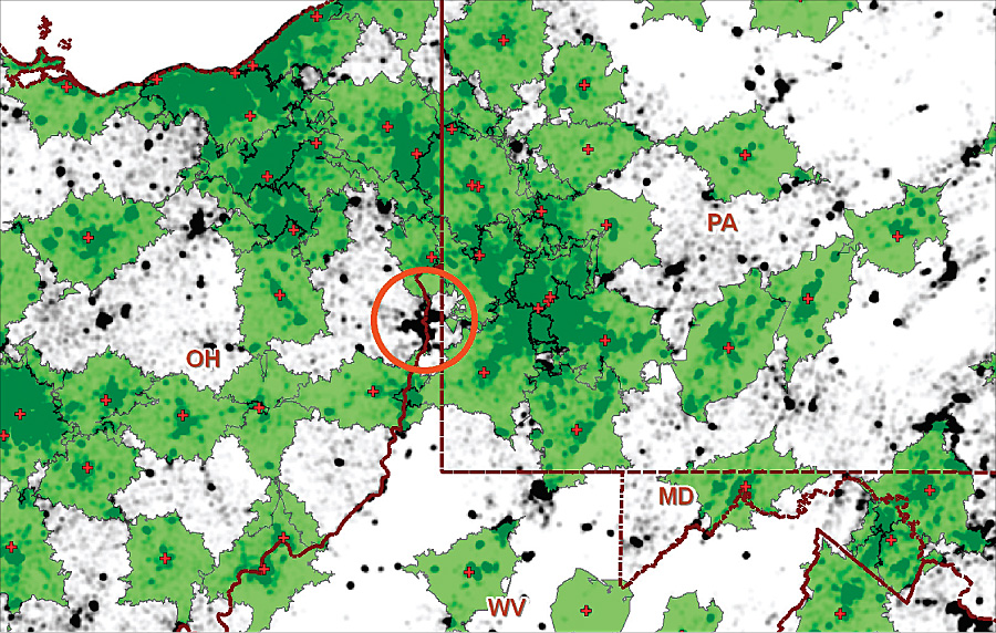
Beneficiary density overlaid by VHA primary care delivery sites (red crosses) and 30-minute drive-time service areas (green transparent polygons). Dark areas not covered by green suggest locations for new clinics to improve overall access to care.
Planning for such a large system requires accurate and timely geographic analysis of facility and enrollee locations. To that end, VHA geocodes its inventory of facilities quarterly and its list of beneficiaries—all 8.5 million of them—annually. This work is done by the Planning Systems Support Group (PSSG) in Gainesville, Florida.
Historically, PSSG provided planners with a host of static cartographic products and statistical reports on access to facilities at all levels of VHA geography. In basic ways, these products identified spatial gaps in access to health care where new facilities might best be located. They also compared local access statistics to various benchmarks.
However, as demand for planning support grew, Duane Flemming, a director in the office of the Assistant Deputy Undersecretary for Policy and Planning in Washington, D.C., realized that PSSG needed to grow as well. The first major goal was to enable hundreds of planners and administrators nationwide with little or no GIS background to perform predefined but sophisticated GIS-based planning activities on their own. This would greatly improve systemwide planning in terms of quality, relevance, and timeliness. It would also free GIS staff to do other planning and ad hoc analyses. The other goal was to enhance and modernize the infrastructure for the GIS staff in Florida and make those resources available to GIS professionals throughout VHA.
Flemming knew that a GIS mapping portal could link both staff and resources. To achieve these goals, he contracted Penobscot Bay Media, LLC (PenBay), an Esri partner in Rockland, Maine, to develop a Web-based mapping and planning portal and upgrade GIS hardware, software, and data infrastructure. He also recruited Dr. Mark Guagliardo, an authority on geospatial accessibility of health care, to help design and manage the project.
The Web Portal
PenBay and Guagliardo based the portal on ArcGIS Server—and a Web-based GIS mapping portal for planners and administrators went online in October 2009. With ArcGIS Server, the portal leverages a number of new technologies to deliver powerful tools with an easy-to-use interface. Planners are able to see how their current facility locations relate spatially to the residential locations of beneficiaries. They can also instantly activate a cached layer that identifies drive-time service areas to quickly find unserved areas that are densely populated with beneficiaries.
With the candidate site evaluation tool, users can choose potential health care facility locations by clicking on the map or entering an address, presumably in a densely populated, unserved area. The tool renders drive-time service areas around the new location. Best of all, the user can request a statistical report on the impact of the new facility on an area of interest (e.g., a VHA health care market area) that gives the number of newly served beneficiaries and the change in percentage of beneficiaries who are within VHA drive-time guidelines. A similar tool assesses the impact of decommissioning an existing health care facility.
A number of additional map layers help planners identify potential non-VHA partners for care delivery in underserved areas. These include point locations for military treatment and Indian Health Service facilities, as well as health care facilities supported by the Health Resources and Services Administration. The portal also supports planning in rural areas, a topic of particular interest to Congress. Users can activate a layer showing urban, rural, and highly rural areas according to VHA definitions for rurality. This and all layers have pop-up metadata in Federal Geographic Data Committee format, a handy resource that has reduced the number of inquiries that must be fielded by PSSG staff. The portal enabled GIS analysts to explore how higher levels of geospatial analysis might benefit VHA planning.
More Information
For more information, contact Dr. Mark Guagliardo, program analyst, Veterans Health Administration (e-mail: mark.guagliardo@va.gov).