ArcNews Online
Fall 2010
[an error occurred while processing this directive]New Version of ArcGIS Explorer Makes Sharing Easier
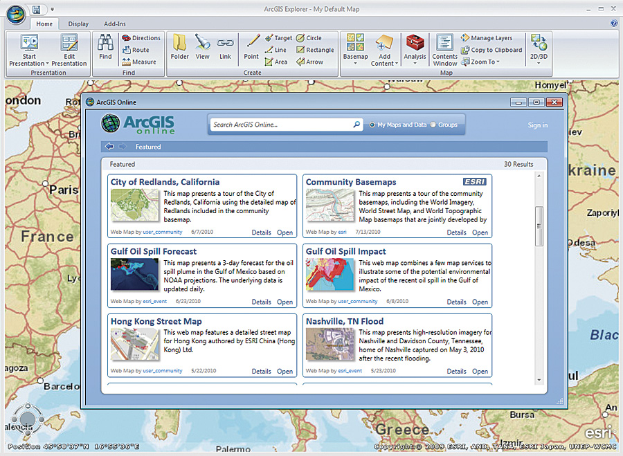
With ArcGIS Explorer, users can search for and add content directly from ArcGIS Online, as well as share map items immediately, to their online account. All ArcGIS Online maps, data, and groups can be accessed from ArcGIS Explorer.
The new version of ArcGIS Explorer offers many compelling features and enhancements, including tools to increase productivity and more ways to share geographic information. It has many updates that help integrate it with ArcGIS 10, including direct support for image services, improved support for ArcGIS 10 layer packages and geodatabases, and more ways to leverage ArcGIS Online.
ArcGIS Online, which is deeply integrated into the ArcGIS Explorer experience, provides an easy way to find and share geographic information and form online communities. With the new ArcGIS Explorer release, users can search for and add content directly from ArcGIS Online, as well as share map items immediately, to their online account. All maps, data, and groups can be accessed from ArcGIS Explorer.
This release of ArcGIS Explorer offers a number of features that support enhanced interoperability, both with the ArcGIS system and via KML. ArcGIS Explorer now allows users to share (export) to layer packages to provide better ArcGIS Desktop interoperability. Users can also export to and create notes from KML. Shared layer packages, notes, and KML can be saved locally, added to ArcGIS Online, or e-mailed directly from the application. KML handling has been improved in both 2D and 3D modes, and region-based KML is now supported in 2D mode.
Additionally, the ability to add data directly from Excel spreadsheets is available. ArcGIS Explorer users directly use and optimize image services.
Many other enhancements have been made to ArcGIS Explorer. For example, OpenStreetMap is now included in the basemap gallery. Notes can now be labeled, and the note, presentation, pop-up, and Analysis Gallery features have all been improved with new tools to help users be more productive and more easily share information. A new query capability enables users to create expressions to filter data displayed on their maps. Enhancements to symbology improve symbol appearance in 2D and 3D modes.
In addition to the free download of ArcGIS Explorer, Esri offers a free ArcGIS Explorer Software Developer Kit (SDK). This SDK has been updated to support Visual Studio 2010, including templates for the new add-in types and an updated add-in wizard. The reference and conceptual help have also been updated, and new samples are included.
ArcGIS Explorer is supported in English, German, French, Spanish, Japanese, and Chinese.
More Information
To learn more about ArcGIS Explorer, visit www.esri.com/explorer.