ArcNews Online
Fall 2010
[an error occurred while processing this directive]OneGeology Geospatial Portal
World's Geologic Survey Data Shared
Highlights
- OneGeology project provides a genuinely dynamic Web portal to make available the world's geologic data.
- Many geologic surveys capture and attribute data and prepare it for the Internet.
- Web mapping services are developed with ArcGIS Server.
Nearly every country in the world has a geologic survey, some of which are the oldest scientific organizations in existence. Geologic surveys, both federal and state, are responsible for maintaining the geologic data and knowledge of their territory. Access to this data benefits the economy of the nation and the health of its people and furthers geoscience. The problem is in accessing geologic data from so many contributors, because it has been collected, stored, and coded with huge variation. Fortunately, today's GIS technology helps collectively show what lies beneath the earth's surface.
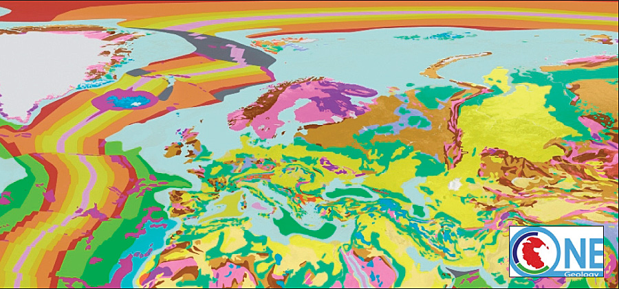
The OneGeology portal joins geographic survey data for a complete view of the earth's geology.
OneGeology (www.onegeology.org) is the first-ever open-access portal to the geologic survey data of the world. Its Web mapping service (WMS) makes the world's geologic data available at a general scale of 1:1 million, and for some countries at scales of 1:50,000. All the data is available to view for free, and an increasing amount is available to download for free. OneGeology ushers in a new era of geography services with the launch of distributed Web service systems, much of them using Esri technology. Many geologic surveys are using ArcGIS Desktop to capture and attribute data and prepare it for the Internet and ArcGIS Server to serve the WMS. GIS users can use geologic survey data to generate specific maps, show correlations, and create basemaps that can be brought as map layers directly into their project environments.
The GIS-enabled portal provides access to a truly distributed system—geology data available and stored on the servers of each country's survey organization. OneGeology also offers access to many regional and global datasets provided by the Commission for the Geological Map of the World. You can see all the geology of Europe, North America, South America, and Asia at a variety of scales from 1:1 million to 1:25 million. Furthermore, the portal allows users to look at metadata, statements of use, and catalogs and visualize geographic data at small to large scales. The original data's format may be diverse, but as long as it is spatially referenced and the contributor has put it into OneGeology's interoperable format, it can be viewed and accessed. Some countries actually provide high-resolution data on their servers that is accessible through the portal.
Geologic mapping varies in approach and detail from country to country, between the developed and the developing world, between Europe and the United States, and even between the countries of one region or the states of one nation. Over the years, geologic survey organizations have faced, and still do face, the challenges of scanning, vectorizing, attributing, and Web-enabling their data. An essential part of the development of OneGeology has been the exchange of know-how and provision of guidance and support so that any geologic survey can take part in serving its data. Participating geologic surveys contribute the best geologic data they can that covers their territories.
OneGeology participants help each other. If a country has geologic data but does not have the technology to serve that data, it can enter an agreement with another country to host the data as a service. For example, Ghana's geologic data is served from the German Geological Survey in Hannover, Germany. The UK serves Afghanistan's data, the Netherlands serves Surinam's data, and France serves Cameroon's data. The French are also helping Cameroon build its technology. The aspiration is that supported countries will eventually be able to serve their own data, but in the meantime, their data is on the Web and accessible. The data, however, remains within the originating country's ownership.
"OneGeology's arms are wide," says Ian Jackson, British Geological Survey (BGS) Operations director and OneGeology coordinator. "OneGeology accepts any geologic survey organization that wants to join and does not turn anyone away; therefore, it has inherently assumed the challenge of getting this data ready to serve. Fortunately, all participants have happily taken up the challenge, and those who have never before been interested in interoperability are now willing to shape and adopt these standards and markup language to make their work more easily accessible through the portal."
Today, 116 countries participate in OneGeology, more than 40 of which are serving data using a Web map portal, protocols, registries, and GIS server technology to harvest and serve data from around the world. OneGeology is a working example of a spatial data infrastructure (SDI). More than 200 map datasets at local, national, continental, or global levels are registered and documented with standardized metadata.
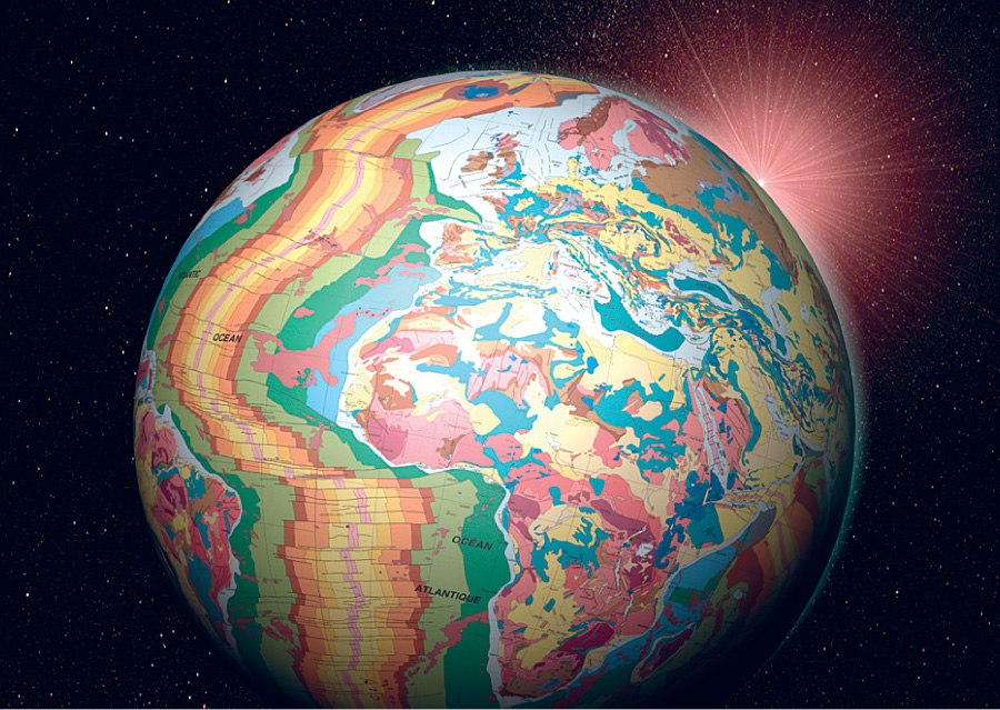
Geology on a 3D globe.
Two regional initiatives are strongly linked to OneGeology. The first is OneGeology-Europe, a two-year project funded by the European Commission that involves 21 European countries. The second is the U.S. project Geoscience Information Network (GIN), which is funded by the National Science Foundation. Within the United States, many states' geologic survey organizations, as well as the United States Geological Survey (USGS), are OneGeology participants.
OneGeology is coordinated through a two-part hub—a secretariat based at BGS and the portal technology and servers provided by the French geologic survey, BRGM. To support the portal and the registry access, BRGM has put in place an infrastructure of 15 virtual servers. The hub is guided and supported by two international groups—the Operational Management Group (OMG) and the Technical Working Group (TWG). The Steering Group, which provides strategic guidance for OneGeology, is composed of geologic survey directors who represent six continents.
The objective of the OneGeology project is to provide a genuinely dynamic Web portal that makes available up-to-date information that can be accessed and consumed by a host of sectors in the international community. To do this, the team needed the model to accept data from its diverse community. It has adopted and helped accelerate the development of GeoSciML—a geography markup language derivative. Developed by the International Union for the Geological Sciences Commission, this application is used to transfer geologic information, and it supports interoperability of information served from geologic surveys. Using this tool allows surveys to more easily share data, communicate, and collaborate through a common language.
Using the Web service address available in the register, each dataset can be displayed in various GIS packages or portals. Built on technology that makes extensive use of Esri products, including ArcGIS Server and ArcGIS Desktop software, the OneGeology system has been designed and optimized to serve, search, and display multiple layers coming from distributed providers. The portal provides the usual visualization tools (e.g., zoom, pan, transparency control), as well as the functionality to save a combination of datasets into a Web map context that can be shared with other users. Maps produced on distributed servers are sent directly to Web clients on the user side. Every participant delivers its geologic data via a standard Web service (WMS, WFS, or WCS). The list of metadata for the map service is collected into a catalog of services, which is centrally managed. The portal can display and aggregate all map data.
To help the participants register their datasets, a Technical Working Group has developed standards, including those for naming the datasets. It also provides "cookbooks" for preparing Web services to deliver maps or features according to GeoSciML standards. These cookbooks are available for download on the OneGeology Web site.
The project progressed much faster than anyone anticipated. At the initiation of the project in 2006, the OneGeology team thought it would eventually show some results in 2012. The idea was so popular that the team was actually able to have data available via the portal by 2008. In 2009, ArcGIS Server technology contributed to giving this global system a boost in performance and extendability. A new version of the portal was released in June 2009 that provides better performance, an improved user interface, and new functions for searching the registry dataset. The services that deliver features (WFS) will be more visible for the users looking for data access and download. A technical evolution from the current "register" to an Open Geospatial Consortium, Inc. (OGC), catalog was achieved before the end of 2009. This makes possible the connection between the OneGeology catalog and external catalogs supporting OGC/ISO standards.
According to Jackson, the missions of OneGeology and Esri—to make spatial data more accessible and add value to that data for societal benefit—are entirely aligned, as is their common goal of improving the quality and consistency of that data through global standards. As many of the geologic surveys that provide data to OneGeology already use Esri technology, this agreement will level the playing field. It means that many other surveys will have an opportunity to deploy up-to-date technology.
The benefits for the scientific and educational communities are enormous. Participating countries are gaining economic advantages as well. Natural resource ventures that normally spend a large portion of their exploration and development budgets on geologic data gathering and harmonization are finding that OneGeology is an entry-level resource to begin their own more in-depth projects. The portal also provides them with the contact information for surveys within the country or region they are interested in exploring. This capability helps countries attract some of these investors.
The progress that OneGeology has made is impressive; however, some serious challenges remain.
Getting in touch with organizations in countries that are not participating in OneGeology and reaching the right people in these organizations have not been easy. Some organizations say they are unable to serve data because their national laws or organization business models require them to charge a fee for geologic map data. A major challenge is that many participating nations will need GIS and Web technology and training to allow them to contribute as they would want. This underlines the fact that OneGeology's goal of knowledge transfer is of prime importance.
Esri is now fully aiding the collaborative endeavor by providing OneGeology with GIS technology and support that will surely improve the Web mapping service capabilities of the participating geologic survey organizations. Participants and users will find a richer GIS experience for publishing and using this geologic data.
More Information
For more information, contact Ian Jackson, Operations director, British Geological Survey (e-mail: ij@bgs.ac.uk). Experience the OneGeology Web site at www.onegeology.org.