ArcNews Online
Fall 2010
[an error occurred while processing this directive]Widespread Adoption of GIS in Public Safety
Highlights
- Miami-Dade County's ArcGIS software-based FLIPPER supplies real-time information from the State of Florida Web site.
- Baltimore Fire uses ArcGIS API for Flex to push out building information quickly and easily to responders.
- The City of Beverly Hills develops GIS tools essential for emergency management and public safety.
Not so long ago, monitoring remote incidents in real time with dozens of camera feeds and sensors linked seamlessly together was something you'd expect from the National Aeronautics and Space Administration (NASA) or science fiction. You wouldn't think of it as something used daily in firehouses or local city government buildings. Public safety agencies have used state-of-the-art computers and information systems to capture data for emergencies, but this type of high-tech emergency management involved multiple pieces that weren't connected, and data certainly wasn't available in real time using a single seamless interface.
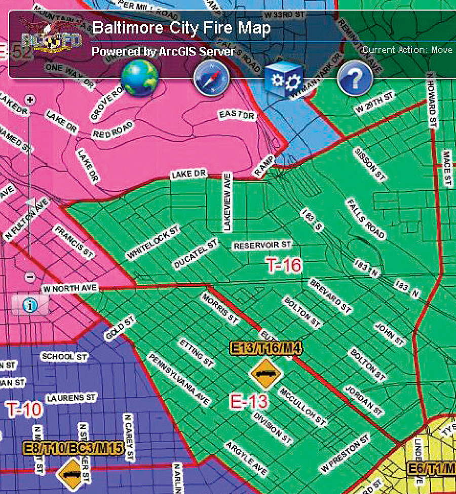
The red lines distinguish the Baltimore, Maryland, inspection area (designated area for hydrant, home visit, and building inspections) for each company.
GIS has long provided an integration platform for meeting the mission of public safety. This includes providing data management, planning and analysis, field enablement, and situational awareness. From 9/11 to Hurricane Katrina to the 2007 fires in California and the more recent Haiti earthquake and Gulf of Mexico oil spill, GIS has been a foundational technology linking data and workflows.
A more recent development has transformed how many agencies prepare and respond to disasters using real-time information.
Esri developed an API—ArcGIS API for Flex—that enables people in public safety to build dynamic, rich Internet applications on top of ArcGIS Server. These agencies can create interactive Web applications that take advantage of ArcGIS Server resources—such as maps, locators, feature services, and geoprocessing models—and Flex components, such as grids, trees, and charts.
This is creating a profound shift in the use of public safety GIS. More agencies can now build an intuitive solution for creating situational awareness. All types of data and information are tied together and viewed in real time using the map as the interface.
Organizations everywhere are building their own systems using ArcGIS API for Flex to more effectively carry out their missions. Following are just a few examples.
Miami-Dade County
The Miami-Dade County, Florida, Department of Emergency Management has unique challenges, even for an agency that expects the unexpected. Since the City of Miami is a tourist mecca and hosts major sporting events, like the National Football League's 2010 Super Bowl and Pro Bowl, providing safety and preparedness can be an arduous undertaking. This is only made more complex by the area's risk of natural disasters.
The agency has developed a solution to meet these challenges. The Florida Interoperable Picture Processing for Emergency Response (FLIPPER) was built to make more information available using the Web and a highly intuitive map interface.
FLIPPER is built using ArcGIS Server and the Flex Viewer. It is integrated with WebEOC, a Web-enabled crisis information management system from Esri partner Esi of Augusta, Georgia, that provides secure, real-time information. FLIPPER gets the data from WebEOC and links it to additional live data feeds.
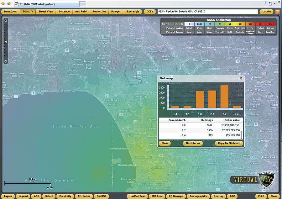
Virtual Beverly Hills is used to visualize real-time earthquake ground acceleration value recorded by the U.S. Geological Survey/California Institute of Technology
As the Gulf of Mexico oil spill stretched from weeks to months—and the impact potentially lasting for years—FLIPPER supplied real-time information from the State of Florida Web site when and where it was needed as the office tracked the oil response.
FLIPPER also helped the county with international responses. "For the Haiti earthquake, we reached out to help with the response, and FLIPPER was a tool we used," says Soheila Ajabshir, systems manager, Department of Emergency Management, Miami-Dade County.
FLIPPER has many tools available. It supplies Request By Exception (RBE) functionality, which allows a person to view more than 6,000 critical facilities, such as schools, fire, police, hazmat sites, and hospitals, based on a set vicinity. Tools and applications, such as Twitter, Bing Maps, hazardous plume modeling, live traffic, U.S. National Grids, and population estimates, are tied to FLIPPER and viewable via the unified map interface. FLIPPER is designed to use WebEOC prepopulated boards/data, such as mass migration and nuclear plants.
Baltimore Fire
Led by fire chief James Clack, the Baltimore, Maryland, City Fire Department serves a geographic area of 81 square miles and a population of more than 640,000 residents. The department has more than 1,800 members, who are divided into two management branches—Emergency Operations and Planning and Administration. The department responds to more than 235,000 emergency 911 calls per year.
For every single call, emergency responders need to know as much information as they can about the incident and its location before responding. Building information is often captured and maintained using large databases, but getting that information quickly and easily to fire personnel responding to a call can be a challenge. Paper notebooks with building preplans help responders know what they're walking into, but they can be cumbersome.
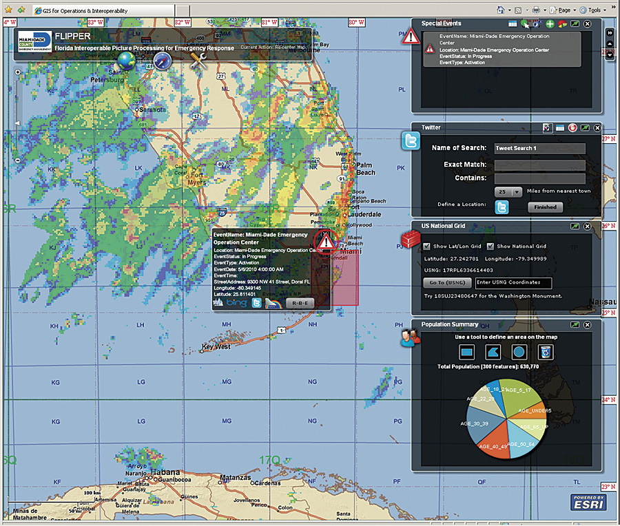
For Miami-Dade County, Florida, live information, such as Twitter and National Weather Service data, is shown in combination with population and the U.S. National Grid on the same map.
Baltimore Fire is piloting the use of ArcGIS API for Flex to push out building information quickly and easily to responders. The agency, which is an Esri 2010 Special Achievement in GIS Award winner, has in just two years built a robust ArcGIS platform. It has developed successful applications, such as its GIS-based digital pegboard, that are changing the way the agency serves its citizens. The ArcGIS API for Flex application is a new method being tested to better supply building information using an intuitive map display.
"This application will aid first responders to view and become familiar with the location of vacant buildings in their districts," says Peter Hanna, firefighter/paramedic and GIS manager, Baltimore Fire. "The first objective of fighting a fire is that everyone goes home, and this joint effort between the city's Housing Authority, which collects the data, and the fire department, which is building the application, will help greatly in firefighter safety efforts."
Fire staff can view the data and pan and zoom to any of the 4,000-plus buildings deemed "dangerous" by the city's Housing Authority. They can then click a particular building icon to see available information specific to that structure.
Virtual Beverly Hills
Known for its affluence and celebrity residents, the City of Beverly Hills, California, also has many emergency management concerns. It hosts major events like the Golden Globe Awards and the Los Angeles Marathon, has dignitaries visiting from around the world, and is situated in an area prone to natural disasters. All this has spurred the city's need for actionable, cross-jurisdictional geospatial information. To this effect, Beverly Hills designed and deployed a unique, city-level version of Virtual USA—an initiative aimed at improving decision making for local, state, tribal, and federal homeland security practitioners. Called Virtual Beverly Hills (VBH), the comprehensive system—based on ArcGIS—helps prepare for and respond to special events, earthquakes, wildfires, and hazmat and explosive material incidents, as well as daily operations like analyzing crime patterns.
"The power of GIS to manage and analyze spatial data, together with its performance and presentation advantages, offered us a good combination," says Lema Kebede, GIS manager of the City of Beverly Hills. "We were able to develop advanced spatial analysis and intuitive reporting tools. This is essential for emergency management and public safety, where speed, usability, interoperability, and availability are critical."
VBH integrates various datasets to provide instantaneous access to situational information from multiple sources. Its enterprise geodatabase hosts more than 120 detailed layers representing all departments. More data is automatically generated from the city's property records, police record management systems, and human resources databases. Live spatial feeds include thematic earthquake shake maps, fire perimeters, weather, closed-circuit television, automated vehicle location, and reported emergency incidents. In addition, users have the ability to view any GeoRSS feed. VBH's security profile controls what data and tools are available for each user. Additionally, integrated analytic tools generate real-time reports.
More Information
For more information, contact Russ Johnson, Esri (e-mail: russ_johnson@esri.com).
Related Podcast
Imagery for Disaster Response and Mitigation
David Blankenship, Senior GIS Analyst, City of Colorado Springs Fire Department, discusses how his agency uses imagery and GIS to tackle the city's emergencies. Listen to the podcast. [08:00 | 19 MB]