3D Data Gives Toulon Provence M�diterran�e a New Perspective
Highlights
- The metropolis needed to better integrate 3D data to benefit stakeholders.
- A solution implemented in ArcGIS enables integration and management of 3D data in multiple formats.
- Users can easily access dynamic, interoperable, and reactive data.
The community of cities known as Toulon Provence M�diterran�e (TPM) is a large metropolis comprising 10 different municipalities around the city of Toulon, located in the Var and the Provence-Alpes-C�te d'Azur in the southeast of France on the Riviera. Founded in 2002, this is the ninth-largest urban center in France (with respect to its population of 560,000 and number of companies—27,000). This is an area with a growing population and a strong economic and cultural life, particularly around its harbor, one of the largest in Europe, which has long shaped its history and its maritime and military vocation.
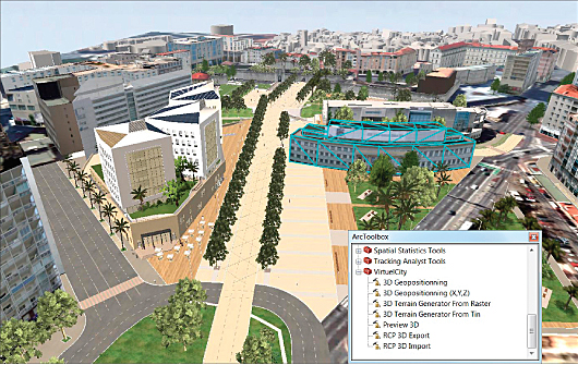
A view of 3D buildings for Porte d'Italie in Toulon, exported by RCP and ready for analysis in ArcGIS.
As in numerous other territories, the governance of TPM is responding to two new expectations. First, the demand for public communication and territorial marketing keeps growing. Second, 3D urban modeling continues to arouse interest among new stakeholders (such as town planners, architects, and the news media). This has caused GIS departments to rethink some of their practices to optimize available data and build tools enabling them to better understand their territories.
This strategy was crucial for the head of GIS for TPM, Arnaud Demellier, graduate of the French National School of Geographic Sciences. Due to his varied career, which includes positions as department manager of an IT company, manager of a regional agency at the French National Geographic Institute, and manager of a bank agency, he understood straightaway the significance of the adaptability of 3D and the requirement of making the data available within end-user departments. He was convinced that there was a developing interest in 3D to support decision making on large-scale urban development projects. Further, he was convinced that the time had come to face this need to better integrate 3D data into its existing ArcGIS platform and thereby more easily manage and distribute the benefits of 3D to other stakeholders and to the public.
Meeting the Challenge
To meet this challenge, TPM purchased numerous high-resolution digital datasets, for example, a high-resolution digital orthophotography dataset, an enriched digital terrain model, and a topographic and altimetric database, among others. In addition, TPM sought a software solution that could integrate with its ArcGIS to manage 3D as easily as a 2D database. Arnaud Demellier knew that this solution would need to enable the importing of its internal and external datasets and manage, structure, exchange, and use raw 3D data without the need for additional resources (3D specialists, etc.), the purpose being to remain autonomous and operational in real time and in a simple way in the face of various demands from the business departments.
Following a careful search of technologies, TPM found the missing link to its 3D chain and enlisted the aid of Esri Partner VirtuelCity of Montb�liard, France. VirtuelCity had developed an ArcGIS plug-in named RCP that enables integration and management of the different formats of 3D data (multipatch, FBX from Revit, DAE, KMZ, CityGML, etc.). This solution allows data administrators to visualize 3D data in a high-definition 3D viewer.
Up and Running
Now, TPM's RCP solution creates new processing chains of data—importing different structures of three-dimensional objects coming from diverse data suppliers and producers. This solution also enables it to better manage the data exports at different levels of modeling (terrain, buildings, texturing, etc.).
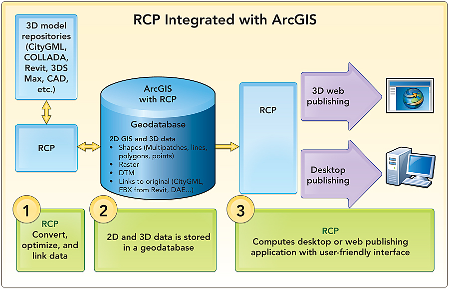
RCP, integrated with ArcGIS, has allowed TPM to keep working in an environment known and mastered by its GIS department. This provides the opportunity to use the analysis tools of ArcGIS on the data integrated by RCP and then manage the 3D data (multipatch and polygons) in ArcGIS after importing to RCP. The training and knowledge transfer guarantee an ease of execution.
Data is dynamic, interoperable, and reactive. Everything can be changed, added, or deleted in the ongoing projects; indeed, RCP allows managing a 3D database in the same way as 2D, expanding possibilities to produce 3D models about projects in any format, extracting from them movies for promotion and real-time 3D web and desktop publishing. It provides a simple and relevant solution to make the management of 3D accessible to anyone and transform GIS into 3D GIS.
For more information, contact Arnaud Demellier, GIS department chief, Toulon Provence M�diterran�e (e-mail: ademellier@tpmed.org) or Fabrice Simondi, CEO, VirtuelCity (e-mail: f.simondi@virtuelcity.com, tel.: 0033-6-82-57-27-96).
Related Podcast
Taking 3D to the Streets
John Ristevski, the founder, CTO, and co-CEO of Earthmine, talks about Earthmine's innovative technology that collects 3D street-level imagery for use in GIS applications. Listen to the podcast. [9:00 | 9 MB]