Brits See the Ground Beneath Their Feet
British Geological Survey Offers OpenGeoscience Web Mapping Service
Highlights
- OpenGeoscience provides map data services using WMS and REST services.
- GIS users can access 1:50,000-scale mapping data and bring it directly into the ArcGIS environment.
- With ArcGIS, users see legends for all geologic layers, including 1:50,000 linear features, mass movement, and bedrock.
In 1848, English geologist Henry De la Beche became the first director of the Geological Survey of Great Britain. He believed that all the geology of the United Kingdom (UK) should be mapped, and he worked hard toward that end. A prolific writer, De la Beche authored many articles and journals about the nation's geology, as well as The Geological Observer, a book that offered scientific methods for studying geography.
Today's British Geological Survey (BGS) continues to advance De la Beche's vision of providing maps of the geology of Great Britain by means of its new OpenGeoscience website. OpenGeoscience offers site visitors free geologic maps of the whole of Great Britain at a scale of 1:50,000. By delivering geologic detail to about 50 meters on the ground, the British can virtually see the ground under their feet.

Geology of London area seen with the Geology of Britain viewer.
"OpenGeoscience provides the public with a wealth of geologic information, including maps, photos, digital data, research reports, and software," says Richard Hughes, BGS director of information and knowledge exchange. "These can be combined with other environmental information to help people better understand their world."
OpenGeoscience is built on ArcGIS Server, which provides the map data services using Web Map Service (WMS) and REST services. Data is in a file-based geodatabase in a central repository. Delivering DigMapGB-50 data as a WMS means that users can view the data within their own systems and integrate it with their own data.
GIS users can access 1:50,000-scale mapping data via the OpenGeoscience web mapping service and bring it directly into the ArcGIS environment. To do this, the user copies and pastes the BGS URL link to a clipboard then, in the open ArcGIS environment, adds a data layer, a GIS server, and a WMS server. Next, the user pastes the URL from the web page in the WMS server, clicks Add layers, adds the service, and sets the transformation. An additional legend item appears in ArcGIS. The user can see all the layers or access them individually. Layers include 1:50,000 linear features, mass movement, artificial ground, superficial deposits, and bedrock.
Available datasets are accessible using BGS GeoIndex, which is a map-based index of information that BGS has collected or obtained from other sources. It includes geologic indicators of flooding; fossil localities; waste sites; BGS rock samples; active mines and quarries; superficial deposits, faults, dikes, and bedrock geology at a scale of 1:625,000; and Landsat imagery.
The primary mission of BGS is to provide geologic knowledge to the UK, so BGS widened its user base by providing a simple viewer for the data service. This add-on proved to be the tool that has made the website so popular in the UK and a model for others to follow. People who otherwise would never have known what to do with a WMS were easily able to interact with the data. The web-based map viewer, called the Geology of Britain Viewer, is built with ArcGIS Server API for JavaScript Extension to the Google Maps API.
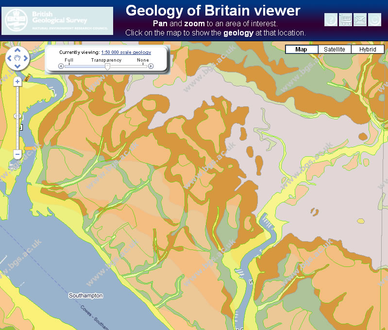
Geology of Britain viewer gives website visitors an interactive experience with geology data.
The Geology of Britain Viewer makes available geologic data easy to visualize at a range of scales. This means everyone can select a location of personal interest and pan and zoom to it. They can click the imagery button to view a satellite image of the area with geology shown as a transparency. This helps people get their bearings. The transparency can be changed by moving the slider. Clicking a geologic feature on the map provides information about the geologic details and a link to more information, such as a description of bedrock geology.
BGS has a vast collection of geologic maps-some of the first having been produced in 1835. The UK has been mapped many times since then. When BGS was doing paper mapping, the country required approximately 600 geographic sheets. Today, the national geologic map is a fully attributed vector GIS dataset.
"Today, what we have is not just a piece of cartography; it is a fully interpreted database accessible via a web mapping service," explains Ian Jackson, BGS operations director. "When a user hovers over a geological feature, the Identify tool shows what the rock is and what the superficial rock is above it. A user can enter a UK postal code and house number and see the geology under a house."
Users can underlay and overlay geologic datasets with other datasets and compare them against land-cover and topography data. In addition, data can be brought into a project, such as cadastre or hydrography. A working example of using geologic relationships is to compare geologic data with cadastral, topographic, and hydrographic layers to calculate insurance risk. In a study for mines, a user can combine geology with slope, mine, and subfoundational data.
The data on the website is entirely that of BGS. BGS developed the website, hosts and serves the data, and adds new datasets. The map data is the latest version of the core geologic dataset.
"Web mapping services now enable us to reach out to the public much more than when we simply delivered GIS datasets to people," notes Hughes. "We decided we were going to harness the power of web services by delivering our geospatial data through that mechanism, and, of course, it has paid off. We now have millions of people using our data on a monthly basis, when previously, we had thousands."
Indeed, the effort has paid off. The site received seven million hits the day of its launch. People enjoy going to the site and playing with geologic science in a fun and compelling way. People working in a variety of industries, such as oil and gas, groundwater, and utilities, are also taking a look at data via the website.
For more information, contact Rob Smith, BGS (e-mail: usingbgsdata@bgs.ac.uk) and visit the OpenGeoscience website at www.bgs.ac.uk/opengeoscience.
Related Podcast
Using Linked Spatial Data at the UK Ordnance Survey
Carsten Roensdorf, corporate data manager for UK Ordnance Survey, explains how linked data helps make public sector data more transparent. Listen to the podcast. [9:00 | 8 MB]