Code for America Drives More Efficient City Government
Working to Use Technology Better
By Matt Lewis, Code for America
It's no surprise that the last few years have been particularly hard on governments across the country. While there's been a lot of attention focused on how the federal government will meet its obligations, there has been considerably less media attention on the fact that most American cities are experiencing significant financial hardship, the results of which may be dire for many citizens.
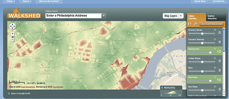
The Walkshed application shows different walk scores for a neighborhood in Philadelphia, Pennsylvania.
Even before the period of budget deficits, our cities weren't operating at full efficiency. As many have suspected for years, when taking a closer look under the hood of an American city, one can see that there is a lot that can be improved: inefficiencies, bureaucracies, and waste.
Many cities are making ends meet by reducing or eliminating existing services. Today there is a new understanding within city halls that the new financial reality facing most American cities will require a new way of thinking about what services and information they provide to their citizenship so that their communities can continue to improve. We at Code for America believe that there are many opportunities to use technology to help governments provide valuable services to their citizens without exorbitant costs. Code for America started with the idea that even as cities cut services they can no longer support, there is still immense potential for them to serve their citizens better.
So when considering the future of the American city, the question becomes, How can we, as technologists, help our cities do more for their citizens with less?
A powerful and cost-effective way to start changing the way that city hall provides services is to focus on making existing information and data available to the public in a way that is easily understood and actionable by individuals and community groups. While governments have traditionally been very good at collecting all sorts of data, it has proved challenging to open this data to and, more importantly, render it into a format that can be easily digested by the public.
Using Mapping Technology Creatively
One of the most powerful tools for making local data useful and accessible to the public, as well as within government, is the intelligent and creative use of mapping technologies. Esri mapping products allowed Code for America to create mapping applications to help both government and citizens better understand what's going on in their neighborhoods and how to change them for the better. Esri software has a large role to play in the creation of applications and other useful public mapping tools.
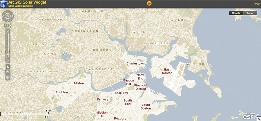
The Solar Widget application for ArcGIS shows house-by-house potential for solar power generation in the city of Boston, Massachusetts.
For example, Aaron Ogle built an application called Walkshed before coming to Code for America that gives neighborhoods a "walkability" score. He built the application with help from ArcGIS for Desktop and used it for distance analyses and to generate a raster layer. Based on adjustable inputs, the application helps visualize the effect geography and services have on a particular area.
Building on Existing Applications
Improving the way that cities provide data to the public doesn't always mean building an application from scratch. Earlier this year, Code for America became aware of Solar City, an application that extends ArcGIS for Desktop Spatial Analyst to calculate the solar radiation available on building rooftops. The project was started in 2008 by the City of Boston, Massachusetts, and allows users to make calculations that demonstrate the potential cost savings of switching to solar power. With the necessary geodata, any city can use this application as a powerful tool to evangelize about and implement effective clean energy.
Seeing the value behind Solar City, Code for America's Ryan Resella took up the task of updating the Solar Widget for the new version of ArcGIS API for Flex and released it on ArcGIS Online, where it's freely available for anyone to use. Creating new applications to help cities is important, but equally important is ensuring that existing applications can be easily used and reused by other cities and municipalities.
These two examples are just a start. The opportunities for developers and other technologists to make a large impact on the public sector are vast. While Code for America focuses on building useful, lightweight, and reusable technology for American cities, our ultimate goal is larger. We want to infuse the lessons and methods from the innovative startup world into the culture of city hall for the better.
Lend a Hand
We need help! We need more smart and dedicated people to help our cause. We're recruiting coders and designers who want to volunteer but cannot spend a year as a Code for America fellow. There is a lot of work to do, and our Code for America Labs Volunteer Corps can use any support you're able to give.
For more information, contact Matt Lewis, fellow, Code for America (e-mail: matt@codeforamerica.org), or visit www.codeforamerica.org.