Emergency Response 2.0
Larimer County GIS Builds Custom Web App to Empower Emergency Managers
Highlights
- ArcGIS for Server architecture is the backbone of an emergency response application.
- The application helps visualize population and infrastructure vulnerabilities.
- GIS manages real-time allocation of incident recovery resources.
By Royce Simpson, GIS Programmer Analyst, Larimer County, Colorado
Larimer County is situated in northern Colorado on the Wyoming border and is home to 29 distinct cities, towns, and communities; among these are Loveland and Estes Park, known as the gateways to the Rocky Mountain National Park, which receives more than three million visitors per year. The county's population is about 300,000.
Larimer County GIS (LCGIS) stores a wealth of spatially enabled data, from site addresses to county shelters to critical infrastructure, such as schools, public facilities, and police and fire stations. When coupled with census and derived Federal Emergency Management Agency (FEMA) HAZUS-MH layers, a rich, queryable tapestry becomes readily available. Map visualization provides a holistic overview of the incident, while actionable reports come from performing spatial queries.
Infrastructure and population layers can be queried to produce timely reports on vulnerable assets.
When an emergency incident occurs, each county manager needs to know what agencies and personnel are involved. Information that is visualized spatially, shared among key players, and updated in real time empowers decision makers, saves lives, and cuts costs.
With the GeoWeb in full swing, there is a proliferation of exciting applications, and few are more promising and visible than those in the emergency management (EM) arena. However, the road to successfully conceptualize, architect, and implement such an application is not an easy one. A high degree of end-user adoption can be achieved by focusing on a few key components, making sure they run flawlessly, and presenting the application in a form that will resonate with the intended audience. More components can be added in subsequent versions if warranted.
Larimer County GIS set out to build an emergency response web application centered on the ArcGIS for Server/map service architecture using ArcGIS API for Flex as the development environment. Because LCGIS already has a highly proficient GIS staff that is accustomed to providing timely mapping products during emergency events, it was critical to the scope of this project that the application be designed to only tackle a few key functionalities and the remaining, more complex tasks be handled by the GIS staff. The application fundamentals are to provide EM managers with a tool that
- Allows instant collaboration
- Visualizes population and infrastructure vulnerabilities
- Visualizes and manages the allocation of resources with their associated hazards
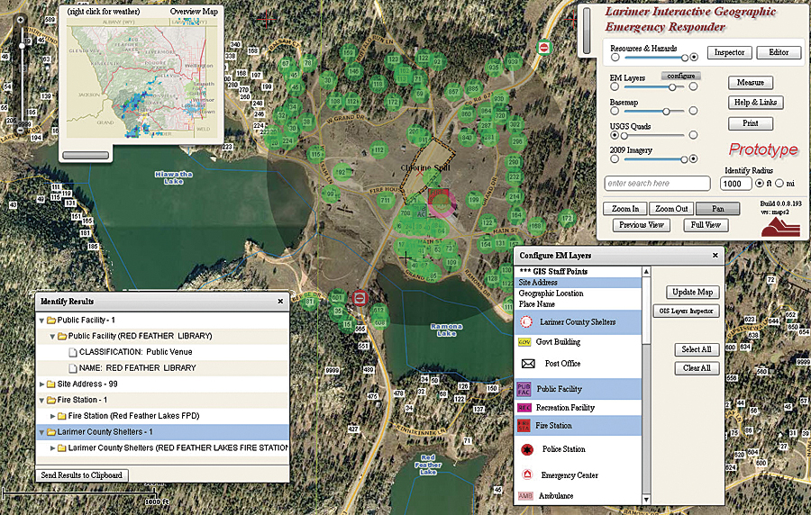
With Jeff Rulli as project manager, the resultant application, Larimer Interactive Geographic Emergency Responder (LIGER), was designed from the ground up to quickly and easily accomplish the above tasks.
Collaboration
LIGER provides a means for emergency managers to always be in touch. When users load LIGER into their web browser, they are presented with a sign-in form. This information persists on the PC and server, and the user can bring up the LIGER status window for contact information on all parties currently using the application. LIGER automatically either logs users out when they close the application or changes their status to "away" if they engage in other computer activities. LIGER allows single-click, as well as more complex, buffer queries for a fast, summarized listing from critical infrastructure layers. This information can be copied to the clipboard and pasted into a spreadsheet or e-mail.
Resource Allocation Relative to Hazards
LIGER empowers the emergency manager to quickly sketch the evolving response effort in real time. Resources can be placed on the map with corresponding levels of readiness, creating a dynamic, collaborative "chessboard." EM staff can update and manage resources as needed while the non-EM audience follows along with read-only instances of the application.
Very large incidents can be visualized and managed in this way so that as the response effort proceeds, resources on the map turn from red (needed) to yellow (allocated) to green (in use). Local government officials can monitor the progress of the incident response simply by bringing the application up on a PC or projecting it on a wall and setting it to autorefresh.
Erik Nilsson, emergency manager for Larimer County and LIGER project sponsor, says, "LIGER is a remarkable tool for the emergency management community here in Larimer County. It is not only a good planning tool with its FEMA HAZUS layers but also a situational awareness tool for a whole host of responders or elected officials who monitor an ongoing incident from their offices. Dynamic situation and resource statuses are mapped out for all to see in real time."
System Architecture
LIGER consists of three tiers: data, web service, and client. LCGIS utilizes Larimer County's enterprise relational database infrastructure, built around Oracle, to house and maintain the raw GIS database tables. ArcGIS then presents those tables to users and applications as feature classes. LIGER-relevant feature classes are organized into map documents, which in turn are presented to the web via ArcGIS for Server map services.
Map services are transparently accessed by the end user through LIGER, which leverages the web browser and the ubiquity of the web to deliver geospatial content and functionality. Currently, the web API choices to consume and present Esri map services are JavaScript, Microsoft Silverlight, and Adobe Flex (the application development platform for the Adobe Flash web browser plug-in).
The LIGER design team decided to develop the application using the Adobe Flex platform for several reasons: It has a huge, open, and thriving application development community; it arguably provides the richest, most user-friendly Internet application experience of all the APIs; and not incidentally, LCGIS employs a seasoned Flex application developer who can quickly translate business requirements into GeoWeb application deliverables. From an end-product standpoint, LIGER is the natural outcome of best practice trends in web-based geospatial functionality.
The Future
Critical to the success of integrating LIGER into northern Colorado emergency response is a set of documented and well-rehearsed standard operating procedures (SOP). LIGER is currently open-ended in this regard, but as local and regional emergency managers familiarize themselves with the application, SOPs will be developed and integrated where relevant.
LIGER is a living application. It will grow and evolve with time. As Larimer County emergency management personnel move more and more into a digitally integrated future, LIGER will be with them.
About the Author
Royce Simpson brings 18 years of geospatial experience to Colorado's Larimer County GIS team. He is a two-time (2009 and 2011) Special Achievement in GIS Award winner recognized for designing and delivering innovative web-based mapping solutions. Simpson currently is GIS application programmer analyst, bringing the Larimer County investment in GIS directly to the citizens and county staff members in a user-friendly, meaningful, and easy-to-understand way.
For more information, contact Jeff Rulli, GIS manager, Larimer County GIS, Colorado (e-mail: jrulli@larimer.org).