How Disaster Ready Are You?
Esri Helps Central US States Participate in the Nation's Largest Emergency Exercise
Highlights
- GIS served as an integration platform that fused basemaps and imagery with live data feeds.
- Esri technical and public safety solutions staff worked with multiple stakeholders.
- True situational awareness was supplied through a GIS-based common operating picture.
On the morning of May 20, 2011, hundreds of emergency responders across the central United States got the alert: A devastating earthquake along the New Madrid fault line had just occurred. Emergency agencies went into full deployment. Evacuations began. Damage assessments were initiated. First aid stations were set up. Security support was deployed. One important fact distinguished this emergency: There wasn't an actual earthquake. It was a drill.
ArcGIS Explorer Online, shown here in presentation mode, was used to support operational briefings.
Eight states, along with federal and local government agencies, volunteer organizations, and the private sector, participated in the 2011 National Level Exercise (NLE). The NLE drill helped assess organizations' preparedness and how they would react to a mock 7.7 magnitude quake that struck along the New Madrid Seismic Zone.
A key element in the exercise was GIS technology. From rapidly understanding what's happening on the ground to cohesively orchestrating the movement of thousands of people, GIS provided an integration platform that fused basemaps and imagery with live data feeds. Its analytic capability made actionable information available for agencies to effectively collaborate.
"The National Level Exercise presented a once-in-a-career opportunity to fully test and stress all the emergency management tools in a realistic response environment across eight states and the federal government," says Brigadier General John Heltzel, director of the Kentucky Division of Emergency Management and current chairman of the Central United States Earthquake Consortium (CUSEC). "Leveraging the capability of GIS allowed us to greatly extend our planning and preparedness for seeing what was needed and what was happening in the impact zone."
Preparation Is the Prize
The 2011 NLE is part of the National Exercise Program (NEP). The NEP gives US government agencies and departments the opportunity to exercise existing capabilities to prevent, prepare for, respond to, and/or recover from major disasters, man-made or natural, and other emergencies in a complex multiagency environment. Participation included federal, state, local, tribal, and private-sector levels. The goal of the 2011 NLE was to address efforts and measure capability to respond to and recover from a catastrophic earthquake in the New Madrid Seismic Zone.
From the terrorist attacks of September 11 through Hurricane Katrina to more recent emergencies like this year's tornadoes and floods, a fundamental lesson learned has been that capturing and sharing real-time information is essential to effective response and incident management. Without it, latency in getting public safety resources to the highest-priority areas begins to compound, the dynamics of an ever-spreading incident are not effectively shared among responders, and the catastrophe worsens.
State officials participating in the exercise used GIS as a platform to connect multiple agencies in numerous locations. It did more than simply visualize information—it provided real-time data acquisition, timely updates, analysis, and dissemination capabilities. In other words, it provided timely and effective situational awareness.
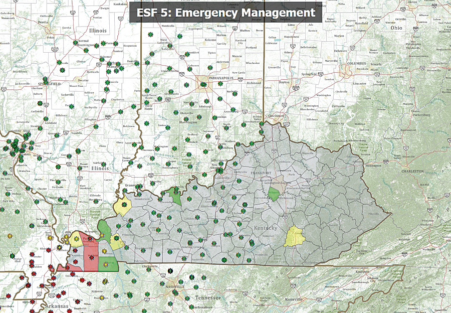
Esri technical and public safety solutions staff worked with multiple stakeholders for over a year to bridge the gap between isolated data silos and true regional situational awareness. Agencies such as the Kentucky Division of Emergency Management (KYEM), Indiana Department of Homeland Security, and the National Guard were provided with GIS technical assistance by Esri staff. Esri worked closely with a number of organizations to define GIS requirements in support of the exercise. Esri also worked closely with staff from US Department of Homeland Security pilot Virtual USA and Esri Partner ESi of Augusta, Georgia, in helping agencies access GIS data services and conduct briefings. To support a number of briefings, Esri worked closely with the KYEM staff to provide a GIS-based briefing tool using ArcGIS Explorer Online with a number of views that provided status on all the emergency support functions (ESF).
ESF briefing maps were created using GIS to show locations of personnel, assets, supplies, and more. They were used for twice-daily meetings to go over what had taken place previously and review current status reports and future action plans.
The common operating picture (COP) was supplied with information from WebEOC incident and event management software, which was provided by ESi. WebEOC is used to assign and track missions and tasks; provide situation reports; manage resources; and prepare Federal Emergency Management Agency (FEMA), incident command system, and incident action plan reports. Esri software powered the computer mapping, spatial analysis, and spatial data management functions of WebEOC software.
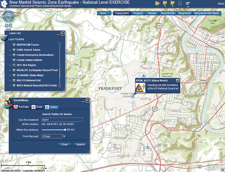
Using a social media widget in the common operating picture, the public information officer (for the Commonwealth of Kentucky Division of Emergency Management) was tracked during the National Level Exercise.
The Preparedness Drill
The 2011 NLE came on the 200th anniversary of the devastating 1811–1812 New Madrid earthquakes. The CUSEC states of Alabama, Arkansas, Illinois, Indiana, Kentucky, Mississippi, Missouri, and Tennessee participated in this National Level Exercise. It was the first NLE ever based on a natural disaster.
The exercise allowed each state, in addition to federal and local government agencies, to validate communications, critical resource logistics and distribution, mass care (sheltering, feeding, and related services), medical surges, citizen evacuation and shelter-in-place, emergency public information and warning, Emergency Operations Center (EOC) management, and recovery. GIS helped decision-making processes in each of these areas.
When the exercise kicked off, Esri staff were present in locations across the United States, including in the Kentucky EOC; with the Unified Area Command in Madisonville, Kentucky; with the mobile damage assessment teams in Murray, Kentucky; at FEMA headquarters and the National Response Coordination Center in Washington, D.C.; and at the National Guard Camp Atterbury Joint Maneuver Training Center in Edinburgh, Indiana.
The GIS-based COP integrated multiple data and communications feeds. It also churned out new information that was sent into the field so remote operators could have a better sense of exactly where to go and what to do.
In addition, a social media feed was available in a GIS-based public information map application. People could log and track geotagged Tweets, YouTube videos, and Flickr photos.
Government response staff operating the COP successfully navigated through large and diverse volumes of incoming data, from simulated building damage assessments to downed road, power, and water infrastructure; impacted populations; simulated injuries; available and incoming food and medical supplies; and the locations and movement of fire, emergency medical services, law enforcement, and homeland security vehicles and staff.
Live data, such as weather, United States Geological Survey earthquake ShakeMaps, road status, field crew locations, and damage assessment, streamed into the GIS database. Outside the operations center, exercise participants could use computers, mobile devices, and web-enabled laptops or Tablet PCs to quickly query and view data.
An ArcGIS Online group—the Group for CUSEC—was created as a mechanism to share data. All the emergency management participants were able to post and exchange data or visualize live maps through the group.
GIS provided comprehensive support for all aspects of the exercise. Whether it was for mass casualty support, damage assessment, ESF status, or other needs, exercise participants benefited greatly from the use of GIS.
Specific examples included police evacuations, roadblocks, and arrests for looting or vandalism; the location and status of fire and emergency medical services and military assets; search and rescue missions; and transportation corridors designated for routing medical, food, and shelter supplies.
Several federal agencies participated in the exercise, using GIS and providing data:
- FEMA established situational awareness using its own GIS-based COP called SAVER2.
- The Nuclear Regulatory Commission monitored the status of nuclear facilities.
- The Transportation Security Administration tracked federal highway status.
- The Department of Agriculture observed the status of food production farms and storage.
Participants deemed the drill successful, since agencies were able to test and evaluate processes, equipment, and technologies and share workflows. Results helped determine best practices, opportunities for improvement, and potential capabilities for future ArcGIS enhancement and development.
For more information, contact Russ Johnson, Esri (e-mail: russ_johnson@esri.com).