Mobile GIS Improves Code Enforcement Services in McAllen, Texas
Highlights
- Code enforcement officers have mobile access to the city's ArcGIS for Server map service in real time.
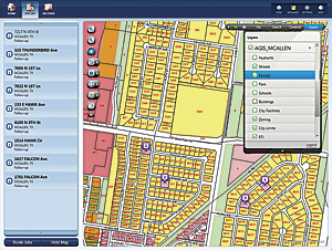
- Inspectors can visually examine the spatial distribution of cases throughout the city.
- Benefits include improved response times, an increase in cases handled, greater staff efficiencies, and automation of daily tasks.
Home to Texas A&M Health Science Center and University of Texas-Pan American, among other schools within the area's bustling education system, the City of McAllen is the largest city in Hidalgo County, Texas, and is located at the southern tip of the state, just a few miles from the United States-Mexico border. With a population of 130,000, the city is rated by the Farmers Insurance Group, the Associated Press, and Kiplinger, among other agencies, as one of the safest, least expensive, and most recession-proof communities in the United States.
Naturally, municipal code enforcement is critical to a city of McAllen's size. Monitoring violations of municipal codes and land-use requirements helps maintain a safe and desirable environment. Faced with a growing workload and reduced revenues, the code enforcement department in the City of McAllen began looking for ways to increase its efficiency and productivity. The solution was mobile GIS.
Prior to the implementation of its mobile GIS, the city relied on a paper-based process that required code enforcement officers to spend valuable time in the office checking several different websites to gather accurate owner, parcel, and address information prior to actually going out in the field to perform their inspections.
To correct the inefficiencies of its antiquated paper-based system, the city conducted a workflow analysis that led to the development of an automated system for tracking code enforcement cases.
Based on this success, the city decided to automate the entire process and equip code enforcement officers with Panasonic Toughbooks, CF-19 laptop computers, and HP Slate 500 tablets used with a web-based solution that includes Accela Mobile Office with Verizon AirCards to access the city's ArcGIS for Server map service in real time. With this fully integrated, enterprise-wide solution, the city began to realize significant improvements in its code enforcement services.
The mobile GIS enables staff to display, inspect, capture, and update geographic information from the field. Collected data includes address, owner, and parcel information; zoning classifications; and physical locations within city limits. Field officers can also file code enforcement cases to speed up data delivery, and the Accela system allows one officer to easily follow up on the status of an inspection or notice of violation performed by another officer.
McAllen's mobile GIS solution enables code enforcement officers to utilize fully functional maps and perform updates in real time, which streamlines their administrative processes and enables faster customer response times.
"Now the code enforcement process is more accurate and efficient, because everything is available in one solution rather than having to go to different sources for the data," says Jose J. Pe�a, applications services manager at McAllen. "Our officers have also gained experience with navigating the city's GIS website, which they had previously only used occasionally. The new mobile implementation not only met but exceeded all our expectations."
Among the benefits the city has realized through access to the ArcGIS for Server map service are improved response times; an increase in cases handled; greater staff efficiencies; and the automation of a number of daily tasks, including workflow management, activity tracking, and report generation.
"During 2010, we processed 16,500 code enforcement cases and 23,100 inspections on those cases. Using mobile GIS as part of the inspection process helps the staff track their data and reach their sites much quicker," says Pe�a. "We wouldn't be able to keep up without the GIS mobile capability in our enterprise solution. Case completion is much faster and makes our officers more efficient, accurate, and accountable for the cases we are working on."
Recently, McAllen's building inspectors have also started to use the mobile GIS solution. They find it extremely beneficial to see inspection locations on a map rather than use an address and directions to find a site. Other mapping applications are on the horizon for the city's planning and development departments.
"The mobile GIS solution is practical and useful and has a direct impact on the quality of service we can provide to the community," concludes Pe�a. "We are able to visually examine the spatial distribution of cases throughout the city, giving us a new perspective on the work being done by our code enforcement officers."
For more information, contact Jose J. Pe�a, applications services manager, McAllen (e-mail: jpena@mcallen.net, tel.: 956-681-1108).
