The City of Fullerton Looks Inward
Cloud-Based GIS Quickly Generates Reports and Supplies Answers
Highlights
- Community Analyst generates reports in minutes.
- The city now has easy access to current demographic data.
- Web-based GIS is helpful for attracting businesses to the community.
Founded as a railroad town in 1887, the City of Fullerton, California, had an economy fueled by both petroleum and Valencia oranges through the 1950s. It is now home to California State University (CSU), Fullerton. With approximately 37,000 students enrolled in the undergraduate and graduate degree programs, the school is among the largest universities in the CSU system and the second largest university in the state of California in terms of enrollment. The city is located 22 miles southeast of Los Angeles, in the center of north Orange County.
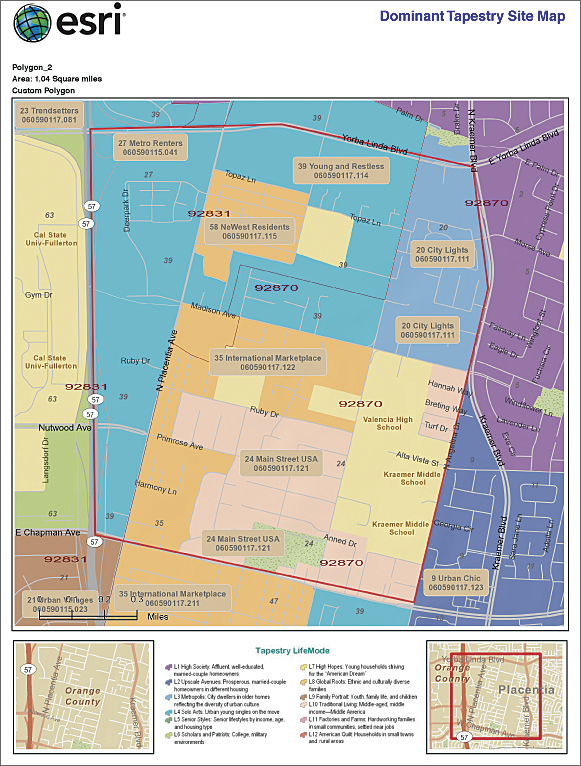
Creating a custom polygon in Community Analyst, City of Fullerton staff can retrieve the census information for that newly defined area.
Staff in the various city departments work cooperatively when it comes to using GIS. Since 2000, city staff have employed Esri software for many applications, ranging from creating maps and exhibits for property owner notification about conditional use permits and new construction and projects to managing addresses for the police and fire departments' computer-aided dispatch. The staff does ad-hoc mapping and data analysis for special projects, as well, including grant funding and understanding changing land use for areas around the city.
The Right Time for Data
Diana McCarthy, a GIS specialist in the city's community development department, needed to understand what the demographics and population counts were for a specific downtown area. "We were interested in knowing how many people visited during different times of the day and what the business climate was like," says McCarthy.
She learned of a free trial subscription to Esri's cloud-based Community Analyst GIS software (see Community Analyst poster) and decided to try it out to produce reports, as well as have easy access to data, a hosted solution in the cloud, and an intuitive user interface.
Using the software, McCarthy was able to create a report that included mapped sociodemographic data and the types of businesses that might be drawn to opening new retail locations in the city.
"Our daytime population is much different than at night," says McCarthy. "Having access to the datasets—like daytime population counts—helps our customers see the benefits of certain locations in the city."
Now, McCarthy can explore 2010 Census data by geography and generate a report in 5 or 10 minutes.
"While we are data rich when it comes to land use or zoning in the city," explains McCarthy, "demographic and population data, including detailed information from the census and actual business locations, are not things we have easy access to through our city GIS installation."
Fullerton staff can now integrate other types of data that come with Community Analyst, such as Esri's Tapestry lifestyle data and aerial imagery.
"Sometimes it's hard for a small city to understand and find all the different datasets that are out there available for us to use," explains McCarthy. "Now we not only have the data readily available, but we [also] know it is the most current out there."
Better Business and Higher Quality of Life
Having access to this assortment of timely information means the City of Fullerton can provide business owners with a better sense of where different types of people live in order to understand whether the city is a good fit for them.
Besides attracting new businesses, McCarthy uses the cloud-based software to help provide information for grants. Recently she has been working on obtaining grant money to open a new park in a section of town that is saturated with apartments and low-income housing.
Another aspect of the solution that city staff find helpful is the ability to create shapes and new datasets with the solution. For example, to look at regional transportation issues and the possibility of creating a transit route in downtown Fullerton, staff could easily create a polygon of the study area and select the data within it.
Being able to provide information about specific areas makes life easier for everyone—from city staff members to the citizen or business owner who is requesting it. Before using Community Analyst, if someone requested demographic information about a specific location, city staff were forced to give them all the information associated with the larger block group or ZIP Code. Now staff can retrieve just the specific area and data, giving customers exactly what they need. "It is so much easier to make better decisions because we have more information available to use," says McCarthy.
For more information, contact Diana McCarthy (tel.: 714-738-6561, e-mail: DianaM@ci.fullerton.ca.us). For more information on Community Analyst, visit esri.com/communityanalyst.