Ahead of His Time
Dr. Stephen Ervin Celebrates the Coming of Age of Geodesign
Dr. Stephen Ervin
Dr. Stephen Ervin is as vibrant as his day of birth—Mardi Gras. Like the celebratory day itself, Ervin is larger than life and full of contagious energy. He has spent two decades working at Harvard University teaching courses, speaking at conferences, and authoring books—mostly about his passion: the intersection of computing, design, and science. "Geodesign has taken over my life," Ervin chuckles.
The assistant dean for information technology at Harvard Design School and director of computer resources and lecturer in the Department of Landscape Architecture, Ervin somehow manages to find time to evangelize and promote the principles of geodesign in various ways around the world.
"When I first heard the term, I thought I'd been using it all my life," says Ervin. "But I hadn't. What is geodesign? Well, to me, it is the fusing of imaginative and functional creativity in environmental design and planning, with analytic geospatial science, informing design with simulations, impact analyses, and systems thinking—all of it enabled by modern digital technology and collaboration tools."
Ervin stops and grins. "That's a big mouthful, but what it really means is that we finally have the means to go about geodesign with all this digital technology. There was no geodesign 50 years ago. Now we have computers, software, satellites, collaboration tools, apps, and smartphones—we have a whole new discipline on our hands."
Geodesign Is Just in Time
Ervin has taken his thoughts and ideas on geodesign and applied them to urban planning projects around the world, including the sustainable expansion of Beijing, China. Ervin has taken on the study of the peri-urban districts located around Beijing with former student and successful Chinese landscape architect Yu Kongjian. "One of the great advantages of being an academic, of course, is having students who go on to vastly exceed your own performance and various accomplishments," says Ervin.

"Digital Landscape," circa 1982 by Stephen Ervin on an Apple II computer.
The peri-urban fringes of metropolitan areas like Beijing are a fertile laboratory for new experiments in integrated land use, transportation, energy, housing, and related developments, says Ervin. The work that he and his Harvard and Peking University colleagues have been taking on for the last three years is hoped to go far in transforming both the practice of landscape architecture and the very continent of China. From singular projects to creating a plan for the ecological security of the entire country to introducing a Pan-Asian geodesign conference to take place in the future, Ervin has high expectations.
"Urbanization, transportation, pollution, health, housing—all sorts of related problems urgently need to be addressed," says Ervin. "Geodesign, in my view, is just in time. We need it. We have big problems. The kinds of complicated issues in the world, on the planet, whether they're transportation or housing or energy or any of them—we need the combined power of collaboration, imagination, and computation to address these issues. Design holds an important half—science, the other half. Their fusion is geodesign."
A Holistic Approach to Plural Processes
In Ervin's opinion, geodesign is something that has been talked about for many years. "We called it computer-aided design," says Ervin. "We didn't mean CAD—we meant design aided by computation, and that's really where we are headed."
One of the defining moments in Ervin's career was reading a book authored by California landscape architect Larry Halprin entitled The RSVP Cycles: Creative Processes in the Human Environment. The concept of plural processes caught his attention. "There is no singular creative process," says Ervin. "There are many of them—just as there are many geospatial operations. And the geodesign challenge is to find how and when to combine them."
What changed his way of thinking drastically was a map at the end of the book. The map had recognizable coastline and forests, but it was also a sort of diagram containing concepts and ideas. "I thought, 'Wow, that's a fabulous combination of kinds of representations combining types of cognitive processes that really characterize design,'" says Ervin. "I've thought about this many times since, that representation is key—both abstract and conceptual on the one hand and concrete and specific on the other. Both are part of what we have to consider during the design process."
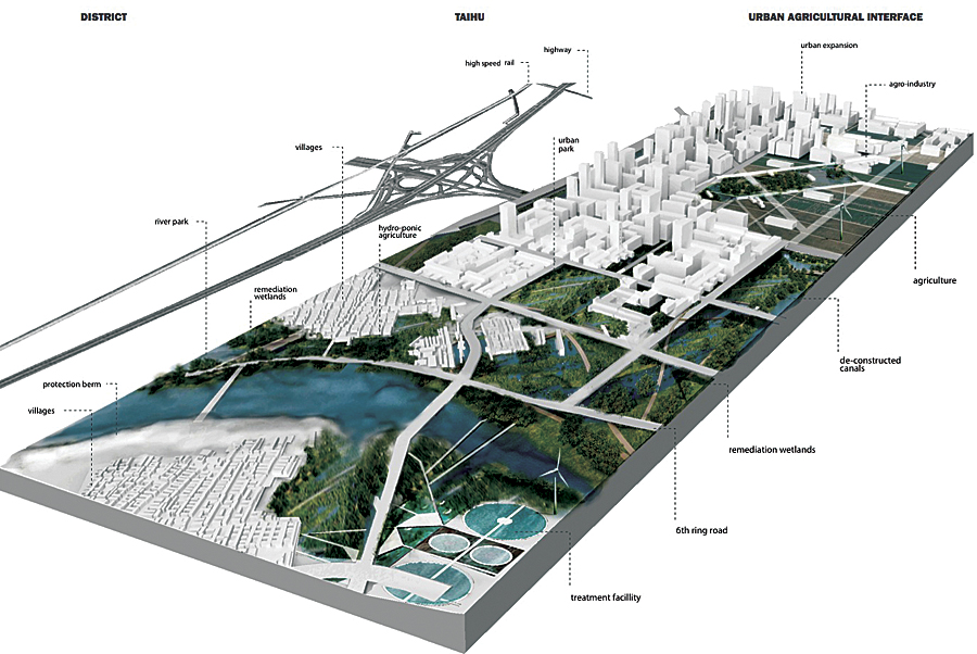
"Urban Agricultural Interface, Taihu District (Beijing)," by Harvard Graduate School of Design students Fadi Masoud, Andreas Viglakis, and Cameron Barradale from Geodesign Studio cotaught by professors Yu, Ervin, Mulligan, and Rowe, 2011.
From Bits of Bytes to GIS
Another defining moment—studying in the graduate school landscape architecture program at the University of Massachusetts in Amherst—introduced Ervin to computer representations of the real world. "I saw this image of ski slopes cut into the hills and the forest clearing that were quite primitive graphically; at that time, trees were little triangles with sticks," says Ervin. "It probably cost days and thousands of dollars for the US Forest Service to produce back in the 1970s. But what I was drawn to was this idea that this took bits and bytes and tabular data about tree positions and species and an elevation model and turned it into a visual representation from which decisions could be made—too much clearing, or not enough clearing, or a little more to the right or left."
The idea that tabular, quantitative data could be combined with qualitative, impressionistic representations was inspirational to Ervin. From here, he discovered synthetic landscapes derived completely by computer programming. "The idea that a natural world could be captured inside of data structures and algorithmic processes really grabbed me," says Ervin.
He bought the most powerful computer he could afford—a Macintosh Apple II—and wrote his own perspective graphics program using a 200 x 300 pixel display. He presented his work at the Laboratory for Computer Graphics and Spatial Analysis at Harvard University where he was introduced to GIS. In 1984, Ervin took this knowledge and began a software company to help landscape architects visualize the results of design decisions.
Four Key Aspects of Geodesign
When Ervin went to teach landscape architecture at Harvard University in the graduate school of design, he felt privileged to work with his friend, colleague, and mentor, Dr. Carl Steinitz, whose course, Theories and Methods of Landscape Planning, was a mainstay for the Harvard curriculum—and whose book, A Framework for Geodesign, has recently been published by Esri Press. For the last 20 years, Ervin, Steinitz, and others, have worked to create and improve a framework fundamental to design processes.
Ervin presented 50 predictions about the future of geodesign at Esri's Geodesign Summit in January 2012. Among these, he considers four to be most important:
- Geodesign is all about water, its purity and availability and the right of every human being to have access to it. Understanding hydrology—how to both prevent dangerous flooding and preserve valuable freshwater resources—is key to every project that people take on and to the future of the planet.
- Projects will depend on not just data and analysis but also dynamic simulations of processes. It is through these simulations that designers can begin to see the real impacts of their design decisions.
- Software for geodesign is going to explode. From crowdsourced data to remotely sensed data to applications and devices, the industry is a virtual tsunami of innovative ideas coming to fruition.
- Systems thinking will be required for geodesign projects. Recognizing that the planet is made up of systems with interacting parts and that everything is connected to everything is important. It's the interaction of the individual components that are key but least understood.
The marriage of science and design is the real challenge to geodesign, so interactions may be orchestrated, and we can see the true impacts of design decisions. The idea that people can have visual feedback for making decisions—such as with the ski slope representations—has become a fundamental driver to what Ervin finds the most exciting about geodesign. "The idea of immediate visual feedback and dashboards to display key indicators that tell us how well we're doing, and in real time, is important," says Ervin. "Whether measuring carbon footprint or total costs or total number of houses, cars, people, buses, or even elephants—it's important to have this kind of feedback and in real time."
For more information, contact Stephen Ervin (e-mail: servin@gsd.harvard.edu).