Argentine Land Registry Launches Territorial Information System
Highlights
- ArcGIS connects the local governments in an enterprise system to manage and edit the geodatabase and publish maps.
- The new system allows citizens easy access to the provincial land registry information.
- The GIS-based web cadastral management system handles 160,000 parcel records and supports more than 80 jobs.
The Dirección General del Catastro Territorial (General Directorate of Cadastre Land [DGCT]) of the Province of Formosa, Argentina, is responsible for managing, maintaining, and updating the geographic information and legal valuation of approximately 160,000 parcels that make up the province, contributing to traffic safety, secure land tenure, land-use planning, and urban financing through property taxes. To continue to fulfill these responsibilities, it was necessary to have reliable, high-quality land information that could be accessed easily and efficiently.
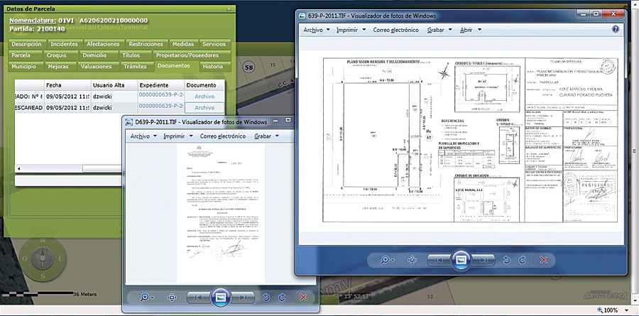
The territorial information system's management module links to digital documents, such as these scanned cadastral surveys and the legal document that validates the transaction.
Officials implemented a new GIS to address these needs and realize their vision of having a digital cadastre that is open and allows citizens easy access to the provincial land registry information. This project involved new technological advances within the provincial administration.
Choosing a Partner
Following careful examination of the available options, DGCT (which is integrated with the property registry systems of the Department of Revenue) and the Province of Formosa selected Aeroterra S.A., Esri's distributor in Argentina, to update the territorial information system of DGCT and build a multipurpose, modern, efficient, and web-integrated application linked to other provincial and municipal administrations, allowing graphic and alphanumeric information to be updated and easily accessible to both the public and professionals.
The comprehensive system involves the use of data, geographic databases, technologies, processes, and staff to generate organizational and interorganizational synergy needed to efficiently manage the new challenges facing modern states.
Updating the Territorial Information System
The main activities included in the updating project were the following:
General Design of the Project—The project design began with a thorough description of the components of the architecture, both software and hardware, as well as the features of each application and the system interfaces. The plan included the migration and integration of data, the training of staff, and change management and implementation strategies.
Administrative Reorganization and Redesign of Processes—Project deliverables included a survey report containing the description, processes, and tasks in each area and a procedures manual with an outline of the proposed procedures, along with the proposed reorganization, justification for the proposed changes, the organizational structure, and job descriptions of each area.
Acquisition of GIS Licenses—Aeroterra S.A. and the Province of Formosa determined that ArcGIS software would ideally suit the needs of the DGCT and the municipalities of Clorinda and Formosa. ArcGIS for Desktop and ArcGIS for Server connected these local governments in an enterprise system to efficiently manage and edit the geodatabase and publish maps.
Information System—The system consists of the following components or subsystems:
- A web cadastral management system to support all the functions and operations performed in DGCT, which has more than 160,000 parcel records and more than 80 jobs
- A consultation and management web system to make available to the community (via the Internet) information residing in the territorial database and facilitate the processing of survey plans by professionals who deal with the provincial land registry (Interfaces will be fully integrated through the Department of Revenue, the Real Property Registration, and Cadastre Municipality.)
Data Migration and Integration—Aeroterra S.A. designed a procedure for migrating data from its existing format to the new geodatabase model based on data migration mapping without generating inconsistencies.
Monitoring and Control—Supervision and quality control of products are supported in SharePoint and the communication protocol designed for this project, speeding up decision making.
The New System Goes Online
The updated Territorial Information System of DGCT was named the Land Information System and was inaugurated and became operational December 2, 2011. The event was chaired by the minister of economy, treasury, and finance, Ms. Ines Beatriz Vecchietti Lotto. Also participating were the director of cadastre Ruben Dario Mirando Bobadilla, general director of revenue Sergio Rios, and undersecretary of provincial unit systems and information technology Luke Vincent.
"The development of new tools aims to facilitate citizen access to information and also enable the government to make decisions in a timely manner, providing secure data necessary to carry out optimal management," said the minister, who also mentioned the provincial state investment in computer equipment and software and the involvement and commitment of human resources in achieving success in implementing the new computer system.
For more information, contact Marco Colaluce, solution manager, Aeroterra S.A. (e-mail: mcolaluce@aeroterra.com), or visit www.aeroterra.com or formosa.gob.ar/catastro.html. DGCT of the Province of Formosa was a recipient of Esri's Special Achievement in GIS (SAG) Award at the 2011 Esri International User Conference.