Spring 2002
Spring 2002 |
|||||||
|
|
|||||||
Amtrak High-Speed Acela Service Uses GIS to Enforce Safety on the Northeast Corridor |
||||||
|
By Jeffrey Stevens and Susan Black, ENSCO, Inc.
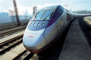
With the increased bottlenecking of interstate highways and longer airport delays, reliance on railroad transportation has been growing. There is great potential to expand rail corridor capacity, or use existing capacity with minimal capital investment, for passenger service and achieve a much greater return on public transportation funds. The U.S. Department of Transportation has designated sections of track as high-speed corridors for transit and passenger rail projects. Subsequent to the September 11 tragedy, reliance on rail travel in the United States is anticipated to increase as the transportation market reacts to possible terrorist activities. The top priority will, of course, be transportation conditions associated with safety. Railroads remain one of the safest of all modes of transportation. As the public places a greater reliance on both conventional and high-speed rail for passenger transportation, it will be essential that the industry maintain its leadership in safety. Within the last year, Amtrak has opened Acela high-speed trains for revenue service on the Northeast Corridor (Washington, D.C.-New York-Boston). This is the first high-speed rail service available in the United States. In response to the addition of this service, Federal Railroad Administration (FRA) officials established new regulations that require monitoring of vertical and lateral accelerations (i.e., the quality of ride) of rail vehicles traveling at speeds in excess of 150 mph on a daily basis.
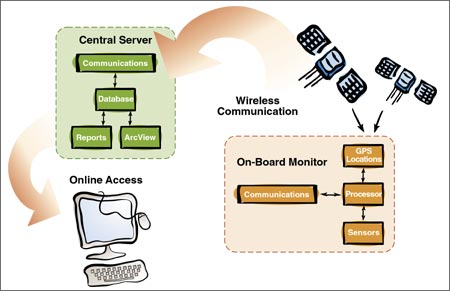
At the time this regulation was developed, there was only one means of collecting the information every day. This involved having a person physically remove the ride quality data collection files at the end of a trip and post-process the information to determine if any rough riding areas exist. This method is time consuming and costly. Amtrak decided to use an FRA-sponsored research and development project that remotely monitors the quality of ride and automatically transmits the information via wireless links to a central database and GIS. The system, called the Remote Monitor System (RMS) was developed by ENSCO, Inc., of Springfield, Virginia. The RMS comprises four main components:
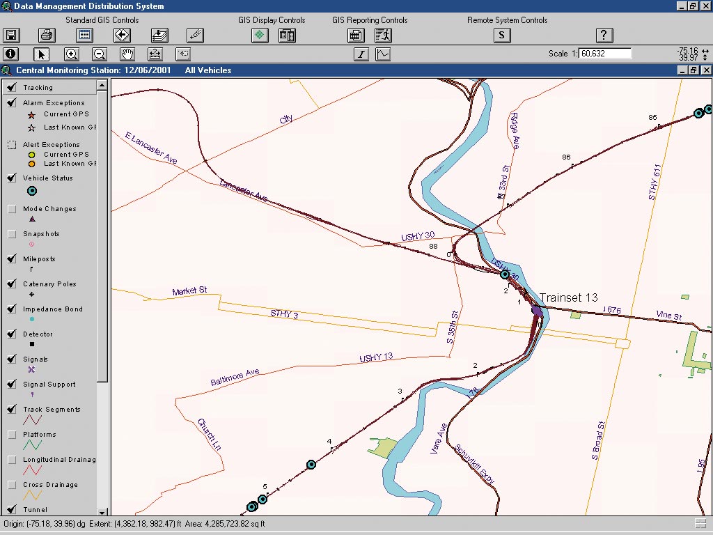
Sets of two data collection units are currently installed onboard six Acela trains. These units consist of a computing platform, accelerometers, and GPS. The computing platform continually receives input from the accelerometers that are mounted on the car body and trucks of the rail vehicle. When the g force output of the accelerometer exceeds set maintenance or safety-level thresholds, four seconds of acceleration data is recorded and tagged at the center location with GPS coordinates. The data collection units also have been programmed to report positional status information in time- and distance-based intervals to facilitate near real-time tracking of the trains. The data recorded by the units is sent directly to an Amtrak communications server via Cellular Digital Packet Data (CDPD). Data is typically sent to the communications server in less than two minutes from the time it was generated. Upon arrival at the communications server, the data is automatically processed and input into the DBMS where it is available for access and analysis by the ArcView 3.2 GIS and Reporting System. "ENSCO's RMS system helps to transcend our already high level of track standards and biweekly track geometry testing," says Patrick Ackroyd, track geometry engineering technician for Amtrak. "The GIS and Reporting System helps to provide us with real-time data of how the Acela trains are interfacing with the rail structure. Since ride quality is an indicator of the early stages of a potential exception, this data can help us to 'nip problems in the bud.'"
Amtrak is using a custom ArcView application to analyze the ride quality information. The GIS application allows users to view the near real-time position of the vehicles, g force values, and location of rough riding sections of track. The application contains additional track structure and planimetric feature layers that help determine why the car is riding rough. This data includes a comprehensive survey of all track structure, mileposts, signals, over- and undergrade bridge information, interlocking locations, and switches. The data has been converted to Esri shapefile format. The user can select a safety or maintenance level event and view the waveform of the accelerations. Statistical analysis and time-based queries have been built into the GIS to assist in determining whether the track or vehicle is responsible for the rough ride. "The GIS application allows us to pinpoint field events and assists us in relating that information to the track inspectors," Ackroyd says. "The inspectors can then address these highlighted locations and fix them--if need be--on their next field inspection." By clicking on icons showing the map location of exceptions, Amtrak can display information about the potential problem as well as vehicle speed and location. For vehicle station stops and other serious, high-priority ride quality events, the system has been configured to send pager messages directly to Amtrak engineering personnel. If the RMS is not in operation or reports a serious ride quality event, the Acela trains must be slowed. Amtrak relies on pager notification as the first level of detection and response. Upon receipt of a safety critical notification, users launch the ArcView application and verify validity of the location and accelerometer data. The additional map information is then used to provide track inspectors with a detailed report of where to search. "The GIS system works as our watchdog to provide data that will help Amtrak ensure the smoothest ride possible for our customers," Ackroyd says. "At recurring ride quality problem locations, the ENSCO system helps us to redirect maintenance assets to resolve the underlying causes including bridge abutment alignment, switch alignment, and fouled subgrade." Recently, the GIS data alerted Amtrak of an undesirable ride at a few undergrade bridges. Maintenance personnel were informed and remedial action was taken before this track section became a safety hazard for the passengers. Daily summary reports are generated for all maintenance and safety-critical data. The information is submitted to the appropriate track maintenance personnel, analysts, and FRA officials. For more information, contact ENSCO's Rail Division chief engineer, Boris Nejikovsky (tel.: 703-321-9000) or visit www.ensco.com. |