Spring 2002
Spring 2002 |
|||||||
|
|
|||||||
Caribbean Coastal Resources Inventoried with GIS |
|||
|
By Ian C. King, Information Systems Coordinator/GIS Specialist, CPACC Regional Project Implementation Unit
The Caribbean Planning for Adaptation to Global Climate Change (CPACC) project was a four-year initiative serving 12 English-speaking, independent Caribbean countries. It formally concluded in December 2001. The project's overall objective was to support participating countries and relevant institutions prepare to cope with the adverse effects of global climate change, particularly sea level rise through vulnerability assessment, adaptation planning, and related capacity building. The participating nations are Bahamas, Belize, Jamaica, Barbados, Grenada, Guyana, Dominica, Saint Lucia, Trinidad and Tobago, Antigua, Barbuda and Saint Kitts-Nevis, and Saint Vincent and the Grenadines. The project involved multiple components involving a range of activities including monitoring of coral reefs, coastal vulnerability and risk assessment, and inventory of coastal resources and uses. The Inventory of Coastal Resources and Uses component was the principal activity utilizing GIS technology and involving GIS capacity building. The main objective of this component was to develop a GIS-based Coastal Resource Information System (CRIS) for each country that would support the types of analyses to be conducted under CPACC as well as to facilitate better planning and decision making within beneficiary agencies. CRIS is an information system based on Microsoft Access and Esri's ArcView 3.2. The front end of the CRIS is a menu system that allows users to browse, preview, export, and print data as well as utilize the functionality of ArcView. The attribute and monitoring data sets are stored in the CRIS back-end database. This design allowed for a quick and cost-effective development of a customized application with full relational database capability. The development of CRIS involved investigating, cataloging, compiling, and incorporating existing analog and digital data from the respective countries. The training activities addressed metadata development, data automation/conversion, database development, CRIS administration, and feature extraction. The approach adopted for the implementation of the Inventory of Coastal Resources and Uses Component involved the following key elements:
CRIS is regarded as more than a simple deliverable. In one sense, it is a process of developing capacity in the form of human resources and tools to inform decision making. As a result, emphasis was placed on developing a rigorous database that would be the foundation of data management. Second, resources were placed on capacity building of the institutions that would receive and be expected to manage CRIS. There were clear indicators of success in the implementation of this component of the project including
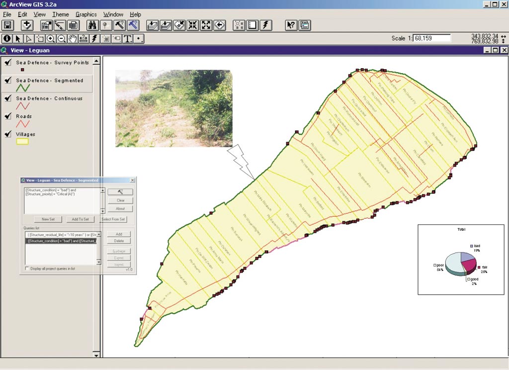
An excellent illustration of the CRIS design is the Guyana Sea Defenses Management Information System (see figure above), a pilot application to provide better access to information on sea defense systems and allow analyses previously impossible. "CPACC is engaged in vital work to improve lives and to better manage natural resources," says Jack Dangermond, president, Esri. "Their work with GIS is an example of the profound impact geography and geographic thinking can have on individuals, organizations, and societies." For more information on CRIS and the CPACC project, contact Ian King, information systems coordinator/GIS specialist at the CPACC Regional Project Implementation Unit (e-mail: kingcpacc@sunbeach.net, tel.: 246-417-4579, fax: 246-417-0461, Web: www.cpacc.org). |