Spring 2002
Spring 2002 |
|||||||
|
|
|||||||
"Proof of Concept" Focuses on Medina County, Ohio
Farmland Preservation Policies Studied with GIS |
|||
|
By Richard E. Klosterman, Loren Siebert, Mohammed Ahmadul Hoque, Jung-Wook Kim, and Aziza Parveen, Department of Geography and Planning, University of Akron
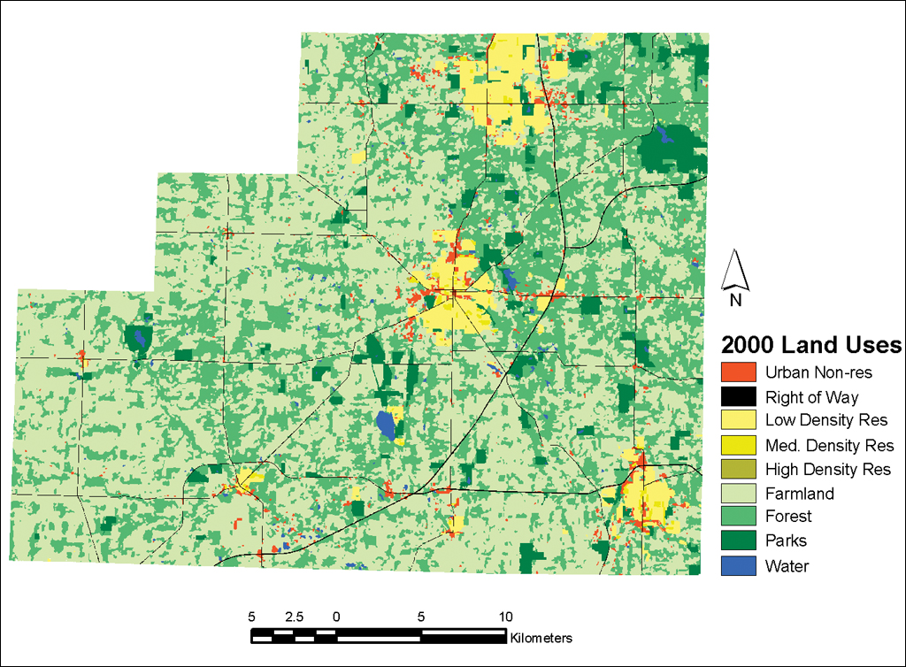
Like many rural counties on the urban fringe, Medina County, Ohio, is experiencing tremendous population growth. Interstate highways provide ready access to the County from Cuyahoga County (containing 1.4 million people and the City of Cleveland) to the north and Summit County (with 540,000 residents and the City of Akron) to the east. This makes it easy for people to work in Cleveland or Akron and enjoy the amenities of rural life in Medina County. As a result, the County's population has grown by 23 percent in the last decade, by 33 percent in the last 20 years, and more than 82 percent over the last 30 years. Eighty-six percent of the County is currently vacant or devoted to agricultural uses. However, a recent analysis has indicated that if these trends continue, virtually all of the County's vacant land will be developed by 2045. Working under a research grant from the U.S. Geological Survey (USGS), researchers at the Department of Geography and Planning, University of Akron, used a GIS-based planning support system--What if?--developed by Esri Business Partner, Community Analysis and Planning Systems, Inc., to produce a "proof of concept" evaluation of two policies for accommodating future growth and protecting Medina County's rural character. The first policy assumed that development would be prohibited in areas with good agricultural soils, wetlands, in the 100-year floodplain, or near streams. The second policy assumed the County would enact a growth policy to limit development to areas that have water and sewer service. It also assumed that the County enacted a staged infrastructure expansion policy in which sewer and water service would be made available to rural areas of the County in a series of three stages. Like many rural areas in the United States, Medina County does not have reliable and up-to-date GIS information. To address this problem, a 30-meter Landsat remote sensing image and ERDAS IMAGINE 8.4 were used to produce a land cover map for the County. ArcGIS 8.1 was used with the digital elevation models (DEMs) distributed on the Web by the USGS to develop a slope map for the County. Data available online from the State of Ohio Department of Natural Resources was used to identify areas that were suitable for agricultural uses, wetlands, areas within the 100-year floodplain, and areas within 30 meters of streams. ArcGIS was used to combine these different map layers into a single shapefile that was analyzed with What if? Extending the 23 percent growth rate observed between 1990 and 2000 for the next 45 years suggested that the County's residential population will grow from 151,000 in 2000 to more than 390,000 in 2045. The County's employment will similarly grow from 50,000 to 129,000 over that 45-year period. What if? was used to determine the impact that these population and employment trends would have on future land use patterns under three farmland preservation scenarios. ArcGIS 8.1 was used to analyze and map the study results. The first "Preservation--No Controls" scenario assumed that development would be prohibited in areas that have prime agricultural soils, are wetlands, or are in the 100-year floodplain and infrastructure availability would not be used to control development. The second "Development--No Controls" scenario assumed that development would be permitted in these areas and growth controls would not be imposed. The third "Development--Growth Controls" scenario assumed that development would be permitted in all areas but that the staged availability of sewer and water service would be used to control the location and timing of future growth. Under the Preservation--No Controls scenario: 10,900 hectares of farmland (19 percent of the current total) would be converted to other uses by the year 2045. None of the County's prime agricultural lands would be lost. However, development would be scattered throughout most of the County, compromising the County's current agricultural character. Under the Development--No Controls scenario: More farmland would be lost--12,300 hectares of farmland (21 percent of the current total) and 5,900 hectares of prime farmland (24 percent of the current total). Development would be dispersed even more widely throughout the County than it was under the first scenario. Under the Development--Growth Controls scenario: Future development is clearly clustered near the existing cities. Somewhat surprisingly, more farmland (13,500 hectares or 23 percent) and prime farmland (6,500 hectares or 26 percent) would be lost under this scenario than under the previous two scenarios. This does not imply, of course, that growth controls will always increase the farmland loss. It only indicates that farmland is more likely to be located near existing cities in Medina County, causing more farmland to be lost if growth is limited to areas near existing cities. Without these growth controls, future residential development will also be scattered throughout the County, reducing the County's rural character and greatly increasing the cost of providing infrastructure. These results indicate that the people of Medina County face a major choice about the kind of community they, their children, and their grandchildren will occupy in the year 2045. If they do nothing, 12,300 hectares of farmland and 5,900 hectares of prime farmland will be lost and development will be scattered throughout the County (as shown in the Development--No Controls scenario). If they establish policies for preserving prime farmland and do not control growth (as shown in the Preservation--No Controls scenario), they can save 1,400 hectares of farmland and 5,900 hectares of prime farmland, but the County will lose much of its rural character. And if they enact policies for preserving control of the location and timing of growth and do not preserve prime farmland, they would lose more farmland than they would without controls but would maintain the County's current agricultural character (as shown in the Development--No Controls scenario). The choice between these alternative futures is one that only the people of Medina County and their elected officials can make. However, ArcGIS and What if? have helped to inform the debaters of the County's future by illustrating the potential effects of implementing different policies for preserving farmland and accommodating future growth. For more information, contact Richard E. Klosterman, president, Community Analysis and Planning Systems, Inc., 78 Hickory Lane, Hudson, Ohio 44236 (tel.: 330-650-9087, fax: 330-650-9087, e-mail: info@what-if-PSS.com, Web: www.What-if-PSS.com). |