Spring 2003
Spring 2003 |
|||||||
|
|
|||||||
A Note From the Webster County Property Valuation Administrator |
|||
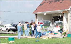
I am Jeffrey D. Kelley, Webster County property valuation administrator. My house was one of more than 150 homes destroyed by the tornado in Providence, Kentucky, on April 28, 2002. Imagine waking up at 3:00 a.m. to the sound of wind and debris hitting the side of your home. Then, when you turn on your TV, you see a tornado warning and a map with circles within a mile of your home, and before you can hear any information, the power goes out! What do you do? You seek shelter immediately. My wife ran and got our four-year-old son, and we hurried to a walk-in closet in the center of the house. As the tornado approached, we heard larger debris pelting the exterior of the home, then windows breaking, portions of the house tearing away, the sound of nails pulling loose, and then a deafening roar with so much pressure we could feel it on the outside of our skin as our ears popped to relieve the pressure. Then, as quickly as it came, it was gone. In just minutes, we had rain-drenched neighbors knocking on our door asking if they could come in because their houses were gone! Our house had maintained some structural integrity and still had a roof on it. As property valuation administrator, it is my duty to assess the fair cash value of all real property in my county as of the January 1, 2003, effective date. Realizing how many properties were involved, I called the Kentucky Revenue Cabinet and requested some assistance in compiling a list of properties to be reassessed for January 1, 2003. Thanks to our GIS program and the assistance of the Kentucky Revenue Cabinet, this has not been a difficult task. Between my homeowner's insurance and a Small Business Administration (SBA) loan made available through the Federal Emergency Management Agency (FEMA) declaration, we have been able to start a new home. It should be completed soon. As a user of GIS, I saw a great benefit in its application; however, I had no idea how quickly we would need it. I am grateful to my office staff and everyone who has contributed in some way to developing our GIS program into a usable tool for identification, information, assessment, and emergencies. See also "Providence, Kentucky, Digs Out From Tornado Damage With the Help of GIS." |