Spring 2003
Spring 2003 |
|||||||
|
|
|||||||
Enterprise GIS Thrives Throughout California's Fastest-Growing Large City
Anaheim, California, Benefits From Fast Information Retrieval and Sharing |
|||
In the early 1950s, Walt Disney had a vision for a family-oriented amusement park unlike any the world had ever seen. His vision soon outgrew the small site near his Burbank, California, movie studios where he had originally planned to build Mickey Mouse Park. Disney hopped in his car and began driving south on the newly completed Interstate 5 until he reached the farm country of Orange County. He marveled at the quaint small town that nineteenth century German settlers had 100 years before named Anaheim for the Santa Ana River that runs through it and the German word for "home." In 1950, the town of approximately 15,000 reminded Disney more of his Midwestern roots than of bustling, nearby Los Angeles. Although some still think only of Disneyland when they hear the name Anaheim, the city's current population of 330,000 makes it roughly the size of St. Louis, Missouri; Pittsburgh, Pennsylvania; or Cincinnati, Ohio. It is also the fastest growing large city in California and one of the 10 fastest growing cities in the United States, according to the 2000 census. It hosts millions of visitors every year and is home to the eighth largest convention facility in the nation. Growth on this scale can be difficult to manage. Today the problem for enterprises small and large alike is not a lack of information but how to manage what can seem like too much information. Those experiencing booming growth may find it difficult to keep up. Experts in city planning have estimated that more than 80 percent of information that city governments deal with is linked to geography. Questions such as "Where should we build a new library?" or "What areas are experiencing rising crime?" can be difficult to answer unless a city's mountain of information can be analyzed spatially. Until 1995, the city of Anaheim was still manually maintaining all of its maps. Like many other cities, Anaheim was looking for better ways to maintain, manage, and share geographic information throughout the city. The inefficiencies of manually maintaining maps led to a contract to convert the city's maps into electronic maps using CAD. Although this step allowed city workers to more easily maintain their maps, they were unable to query or analyze the maps in a productive way. Anaheim's Assistant City Manager Tom Wood, known throughout the city for being proactive in acquiring new technology, took a one-hour drive to Esri's California regional office in Redlands, California, to learn more about how GIS might be implemented for the city. After several hours spent meeting with Esri's staff, the city asked Esri to conduct a needs assessment, which was soon followed by an implementation strategy. In 1997 Esri was contracted to lead the city in a pilot project; Esri delivered hardware and software, developed custom applications based on ArcView 3.x, and converted the city's CAD basemaps to shapefiles. In June 2001 the city resolved to eliminate redundant copies of data accessed by users and applications and use only ArcGIS software for data maintenance and application development. That goal has now been achieved through the implementation of an enterprise GIS environment using an ArcSDE geodatabase. In less than a year, this implementation was completed, and the city of Anaheim is now taking advantage of the benefits that come from an enterprise GIS. OrganizationLocated within the Public Utilities Department is a group of city employees that supports the core functions of the overall city GIS program. These functions include (1) administering GIS software and databases, (2) maintaining the base layers (e.g., parcels and streets), and (3) developing applications for citywide use. This provides a foundation for other departments to build upon. The core GIS group consists of a GIS analyst and two GIS operators. The GIS manager is responsible for managing the core GIS group and providing GIS-related direction and support to other city departments. These departments use their own GIS staff of varying sizes to build and maintain data and applications specific to their needs. This decentralized organizational approach was selected for the following reasons:
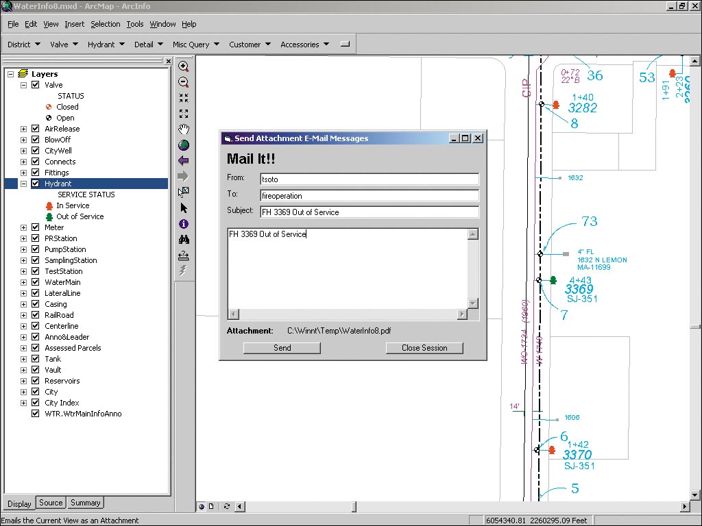
Enterprise GIS at the city of Anaheim consists of many different departments and divisions working on top of a central GIS knowledge foundation. Central GIS develops broad parameters, devised by GIS professionals throughout the city, from which all units work. Through this structure, the various departments can benefit from each other's work and provide customers with the most recent data and information with the highest accuracy and greatest depth available. Participating departments include water, electric, planning, community development, fire, and police. The city shares data with other regional public agencies such as the Orange County Water District, Orange County Sanitation District, and the Anaheim School District. Sharing Spatial Information Across the EnterpriseThe implementation of GIS across the enterprise has led to information sharing in ways the city hadn't imagined just a few years ago--particularly between its utilities and other city departments. The Water Utility employees who operate the state-of-the-art Lenain Water Treatment Plant are responsible for managing the flow of water throughout the city. "If there is a break, they have to know how to service the system," says Mark Lopez, GIS supervisor for the city of Anaheim. "We developed a customization of ArcView 8.x that allowed them to view the data directly from the geodatabase," says Lopez. "When an edit is performed, the operators get to see it as soon as it is posted. They also have much more flexibility in how they locate information. Where once they had quarter-section maps, now they have a seamless map, and they now have the ability to simply input an address and go directly to that address without having to first locate the correct map in an atlas." Lopez continues: "Previously when a hydrant was put out of service due to maintenance or an outage, they'd have to let the Fire Department know, and a consistent, effective system for doing that wasn't in place. Now the system is set up so that when a hydrant is put out of service, an e-mail alert is sent directly to the Fire Department showing a map of the affected hydrants." The citizens of Anaheim can also access needed data via front counter workstations and, soon, from the city's Internet Web site. For more information, contact Mark Lopez (tel.: 714-765-4207, e-mail: mlopez@anaheim.net) or visit www.anaheim.net. |