Spring 2003
Spring 2003 |
|||||||
|
|
|||||||
New Extension Supports Geocoding, Routing for Field-Workers
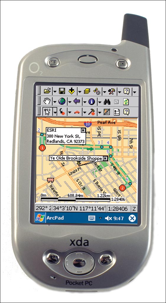
Announcing ArcPad StreetMap |
|||
The ArcPad StreetMap extension provides high-quality street mapping, geocoding, and routing capabilities to GIS users in the field. ArcPad users will immediately benefit from a personal digital assistant (PDA)-based street-level database integrated with their existing field data. High-Quality DataArcPad StreetMap includes high-quality data for the entire United States from Esri Business Partner Geographic Data Technology (GDT) (Dynamap/Transportation). GDT provides detailed data that is optimized for routing. The data is compressed and includes predefined symbology and scale-dependent layers, making it easy to get started. The ArcPad StreetMap extension also includes a desktop tool to select, extract, and automatically transfer a specified area for use on your handheld device. Users can define their own areas and are not limited to common boundaries such as a ZIP Code or county extent. Geocoding and Reverse GeocodingWorkers in the field can easily find a location either by entering a street address or by using latitude and longitude coordinates. Reverse geocoding enables users to receive information in the field about a location with the simple tap of a map. Using input from a GPS receiver, users can find their exact street location. Once an address has been located, it can be used as a stop on a route. RoutingUsing ArcPad StreetMap, field-workers can easily locate addresses and quickly find the optimized route to them. Users can also create dynamic barriers to work immediately around construction zones, accident sites, and other undesirable locations. ArcPad StreetMap supports point-to-point, multipoint, and the perennial sales problem of determining the shortest routes to several locations. Trip management tools allow flexibility. Potential ApplicationsPotential applications for ArcPad and the StreetMap extension include delivery vehicle routing, inspection planning, work order routing, inventory management, traveling salesperson routing, and incident reporting. AvailabilityArcPad StreetMap requires ArcPad 6.0.1 and is supported on Pocket PC and Pocket PC 2002. ArcPad StreetMap is not available for use on Windows Desktop computers. Data for areas of the world outside the U.S. will be available later in 2003. For more information about ArcPad StreetMap and ArcPad, visit www.esri.com/arcpad. To purchase ArcPad StreetMap in the United States, visit www.esri.com/shop, call Esri at 1-800-447-9778, call your Esri regional office (to locate your regional office, visit www.esri.com/usa), or contact your local reseller (to locate a reseller near you, visit www.esri.com/partners). Outside the United States, contact your local Esri distributor; see www.esri.com/international. |