Spring 2003
Spring 2003 |
|||||||
|
|
|||||||
Investigating the Past Beneath Aydincik, Turkey
Applications of Mapping and GIS at the Kelenderis Excavation Site |
|||||
|
By Ali Erdi, Savas Durduran, G�lg�n �zkan, Selcuk University, Konya, Turkey
The contemporary town of Aydincik is situated on the Mediterranean coastline near Mersin, which is in the south of Turkey. Aydincik was built over the years on the site of the ancient city of Kelenderis, which, it was said, was founded by Sandokos, one of the well-known local gods of the Cilicians. Evidence for the first population of the city is slight, though the name must have been derived from Luwians, who were thought to be kin to the Hittites. Owing to the suitable location on the sea routes between the East and West and to the resources, such as forests and mines--especially iron and lead--on the plateau near the city, Kelenderis was probably the metropolis of the Hilakku region in the Iron Age and played an important role in the sea trade. The Phoenicians and Ionians colonized the city at the end of the eighth century B.C. The region was controlled by Persians in the fifth and fourth centuries B.C. After the defeat of Persia by Alexander the Great, Kelenderis established very close relations with the Ptolemaic Egyptians. After the dawn of this Ptolemaic patronage in the region around 100 B.C., Kelenderis appears to have allied with the Romans against the Isaurian pirates. In the first half of the first century A.D., when "rough Cilicia" was annexed to the Kommagene Kingdom, the city probably lost its independence. In late antiquity, the city became smaller and lost importance as a harbor. The city was destroyed by the Parthians around 260 A.D. There are very few remains standing in the town of Aydincik today. Fortification walls from the Middle Ages that encircle the peninsula on the southern part of the harbor and a few rows of classical foundations can still be seen. The remains of the theater are filled almost completely with earth. Remains of a bath can be seen near the harbor. Focusing on TombsIn addition, in the necropolis of the town, there are various types of tombs from the classical, Hellenistic, and Roman periods.
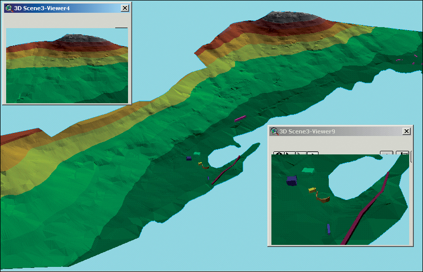
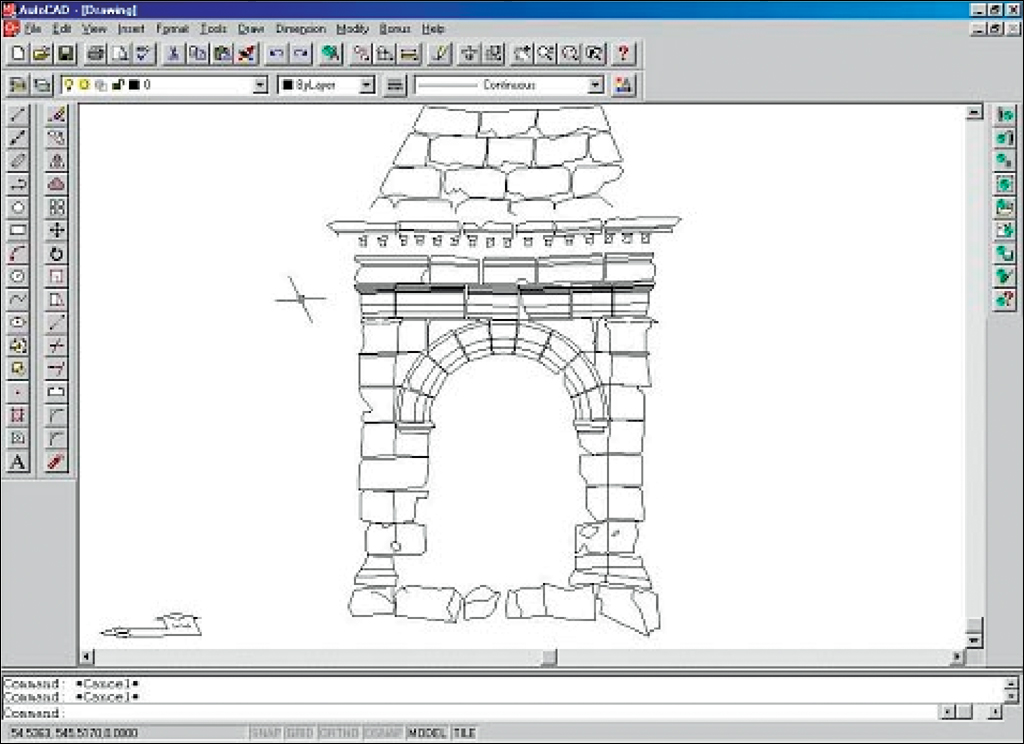
Selcuk University, Konya, Turkey, began excavations at Kelenderis in 1987, revealing various remains from the archaic period to the late antiquity. Significant information about the antique age of the city structures has been determined by locating cultural and historical assets, especially historical tombs and graves, and developing digital elevation models (DEMs). A map of archaeological sites is being made to achieve their appearance and sizes in digital form. The data obtained by geodetic and photogrammetric methods was processed in a GIS environment. Layers of the excavation site and its environment were then obtained after analyzing the data collected. To map Kelenderis excavation sites, which occupied almost the whole town of Aydincik, the process was divided into phases. Each phase required the results of the previous phase (i.e., the historical details that were determined during the excavation). Considering the historical features of the objects, the surface, and the limit points, geodetic measuring was carried out. The altitude data that would enable the drawing of a three-dimensional map of the area was taken into account in measuring, and this data was stored digitally for later computer processing in the laboratory. Photogrammetric Measuring StudiesHistorical graves in the excavation site were measured and evaluated by using close-range photogrammetric methods. A polygon network was established around the mausoleum to obtain the photogrammetric measurements of the pyramidal-roofed mausoleum. About 20 points on the surface of the mausoleum were determined with the aid of the polygons, and these points were coordinated by the method of estimation. The Sokkia PowerSet 2000 instrument was used to measure the mausoleum. The pictures were taken with a digital camera from five or six points to form a model. These pictures were stored in the computer and evaluated using PhotoModeler 3.0, and then the drawings were obtained in DXF format. Once the collected data was assembled in the laboratory, the following procedure ensued:
Understanding the Past Can Help the PresentIn this study, the site of graveyards may help broaden the understanding of the social and cultural structure of the city of Kelenderis. An attempt is being made to determine the geospatial relationships between the old Kelenderis and the town of Aydincik today. When the excavation process has been completed, historical graves, baths, and ancient remains will have been unearthed. The map applications of Kelenderis, including the excavation sites and images, will help Aydincik city planners, designers, and architects gain different viewpoints, and thus the developing areas of the city can be determined better with the use of GIS. ConclusionThe view of the ancient city of Kelenderis' location and the slope map have been formed with the help of the maps that have been obtained from ArcView. In fact, all the studies with GIS are helping lead researchers to see the differences and similarities of choice by analyzing the historical structure formed in Kelenderis in the past and present situation of Aydincik today. For more information, contact Ali Erdi, Selcuk University, Konya, Turkey (tel.: 090-332-2231900, e-mail: aerdi@selcuk.edu.tr). |