Spring 2003
Spring 2003 |
|||||||
|
|
|||||||
Common GIS Design Template for Hydrography and Hydrology
Arc Hydro Data Model Update |
|||
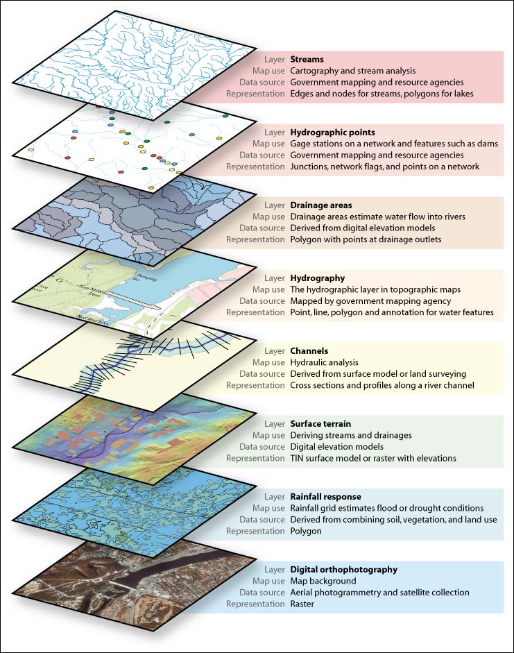
The Arc Hydro data model has been designed in collaboration with a number of international organizations, end users, and application developers. The design goal is to provide a simple data model template that can be used for analysis and hydrologic engineering studies. As the project has progressed, agencies that produce hydro data sets are also beginning to share data based on the design. The National Hydrographic Database (NHD) is the most widely used hydrographic data in the United States, and this data will soon be available in a geodatabase using the Arc Hydro data model at nhd.usgs.gov. The ArcGIS Hydro Framework Data Model diagram highlights the Hydro Framework data model [PDF-5.87 MB]. These are the basic feature classes or "core" model that can be used for a hydro project. The complete specification, including a sample database, is at support.esri.com/datamodels. You can also purchase the Esri Press book Arc Hydro: GIS for Water Resources from www.esri.com/shop. Why Is a Data Model for Hydro Important?Ideally, the data layers in a GIS should be usable for traditional GIS applications as well as for cartography. In the past, hydro data has often been considered just the blue lines on a map. Both the data producers and the data consumers had this view for a number of years, but as technology and hydro modeling techniques have evolved, the need for something more than just blue lines has become important. For many organizations performing hydrologic studies, data preparation has taken too long, and studies turned into data management projects that could not produce results quickly. The solution was to find a simple, multipurpose data model that can be used at local, regional, and national scales that is analysis ready for end users but still meets traditional mapping and cartographic needs. The common data model represents a practical implementation that leverages industry's best practices. Wide adoption of the data model by GIS organizations is under way. Ongoing WorkWork to date has been led by Dr. David Maidment and the Center for Research in Water Resources (CRWR) at the University of Texas at Austin. We are pleased to announce that a second phase of this project has begun; the focus of this research will be on further integration of GIS and water resource modeling software. Other significant initiatives include the development of a data model for groundwater and integration with ArcGIS 9 geoprocessing capabilities. Further information and support for Arc Hydro can be found at www.crwr.utexas.edu/giswr. |