Spring 2003
Spring 2003 |
|||||||
|
|
|||||||
Esri Technology Supports Interoperability, Data Sharing
Building GIS Catalog Portals |
|||||||
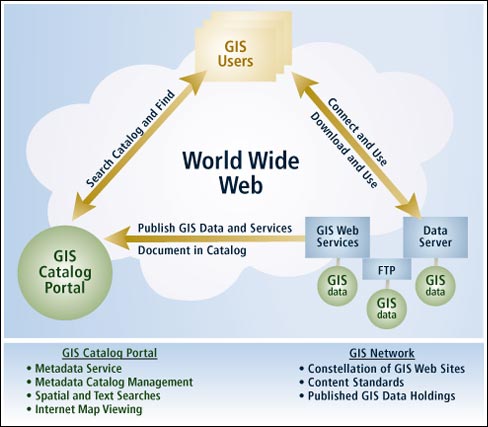
There is widespread recognition that the data layers and tables in most geographic information systems come from multiple organizations. Each GIS organization develops some, but not all, of its data content. At least some of the layers come from external sources. Thus, GIS data management is distributed among many users. Hence, GIS users need a mechanism to efficiently catalog and search for available geographic information and to openly share this information. The deployment of operational GIS catalog portals allows for the easy discovery and use of geographic data holdings and Web services. Portals such as the U.S. government's "GeoSpatial One Stop" provide a solid foundation for a one-stop shop to register multiorganization geographic data and services. GIS catalog portals can be built using Esri's standards-based ArcGIS and ArcIMS software, and many are in use today. What Is a GIS Catalog Portal?A GIS catalog portal is a one-stop Web application that provides the ability to search a catalog that references numerous GIS holdings such as geographic data, Web mapping services, data collection activities, references, and contact information about GIS professionals. Each catalog can reference GIS content that is managed and held locally as well as content held in other GIS nodes on the Web. It is envisioned that a network of GIS catalog portals will form a Spatial Data Infrastructure for both national and global use.
GIS catalog portal users are able to do the following: Search a GIS catalog portal for image and feature Web services, images, geographic data sets, contacts, activities, and clearinghouses. GIS users will be able to perform searches in real time on GIS metadata or on multiple metadata clearinghouse nodes through the GIS catalog portal. Users can set geographic search boundaries or use a graphic selection tool to define a search area. Search criteria can be based on content type such as Web map services, geographic data sets, a data theme, or a date range. Search results will be displayed with metadata about the product and a map, if appropriate. Saved search criteria will be stored in a favorites section and enabled based on the user account information. Register for notification when new or updated data, maps, activities, references, etc., have been added to a GIS network that occur in a favorite search area. View metadata records to determine if a candidate data set is suitable for the intended use. Access and view geographic data and Web services directly through a GIS catalog portal when available. Maps can be viewed in the Web browser or with GIS software, such as the freely available ArcExplorer, to display multiple data sources along with data from local sources. Download geographic data from providers through feature streaming or FTP services for large data sets. Publish (register) map services, images, geographic data sets, geoservices, spatial solutions, geographic and land reference material, and geographic activities or events to share with others through submission of online forms within a GIS catalog portal. Data providers will have the ability to update their metadata submissions. GIS Networks
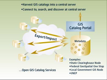
A GIS Network is a constellation of user sites that publish, discover, and use geospatial information on the World Wide Web. A GIS catalog portal will be a place where GIS users can search for and find GIS information relevant to their needs and, as such, depends on a network of published GIS data services, map services, and metadata services. Periodically, a GIS catalog portal site can harvest catalogs from a collection of participating sites in order to publish one central GIS catalog. Thus, a GIS catalog can reference data holdings contained at its site as well as at other sites. It is envisioned that a series of catalog nodes would be available to form a network--a Spatial Data Infrastructure. GIS Catalogs Are Like Card Catalogs in LibrariesThe information holdings in a GIS include a broad range of data types in various media. Each should be documented, indexed, and cataloged for searching and sharing. For example, GIS holdings can include static and interactive maps, map layers, applications, analytical models (e.g., geoprocessing scripts), reports, data sets and databases, GIS Web services, and much more. Each of these items can be documented using standards-based metadata. The catalog is an ordered collection (i.e., a database) of these documents and serves the same purpose as the card catalog in a library. In an enterprise or departmental GIS, the GIS catalog can be more than simply metadata documentation about published data sets. It can also be the data dictionary for an organization and can help organize all of the information sets and results produced by a GIS. What Would This Approach Accomplish?The two goals of this approach are to develop the GIS catalog portal and to create a network of geographic publishing nodes throughout federal, state, tribal, and local governments. The central focus of the GIS catalog portal will allow for discovery and use of geographic data holdings and the emerging geographic Web services. The approach would result in a GIS catalog portal that
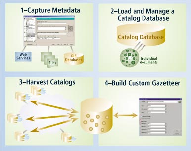
Esri's ArcGIS Desktop 8.3, ArcSDE, and ArcIMS 4.0.1 provide the technology needed to build and manage such GIS Networks. A technical paper providing more information about the methods and procedures for implementing GIS catalog portals can be found on the Esri Support Center. |