Spring 2003
Spring 2003 |
|||||||
|
|
|||||||
Managing Invasive Weeds and Wildlife Using GIS |
|||||
|
By Leif Johnson, South Dakota Department of Game, Fish & Parks
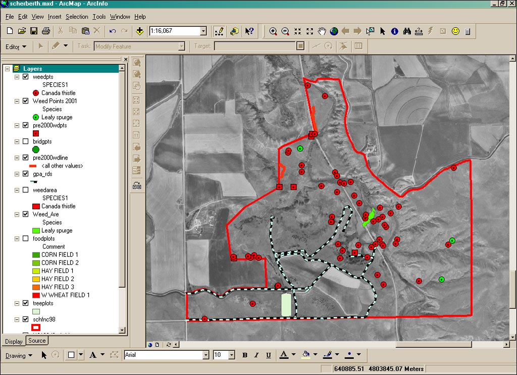
Introduced, nonnative plant species cost the United States economy $27 billion annually. In South Dakota, seven nonnative plant species have been declared as invasive weeds. These species cause approximately $140 million in annual losses to agriculture in the state. Because of these high losses, South Dakota, along with other western states, spends a premium amount each year to control them. Besides the losses to agriculture, nonnative invasive weeds attack and cause significant disruption of natural ecosystems where these invasives can outcompete native plants. The South Dakota Department of Game, Fish & Parks (SDGFP) Region 1 in western South Dakota manages 27,000 acres of public land specifically for the benefit of creating habitat for native wildlife and game animals-Game Production Areas (GPAs). Part of this management is controlling the spread of invasive weeds. For more than 50 years, the SDGFP has managed to prevent the spread of invasive weeds. Management techniques have focused on using two combatants: specialized chemical agents (for spraying) and biological agents (insects that eat only certain plant species). Before the use of GIS and GPS technology, locating problem areas was primarily by word of mouth. These areas were either located by notification from adjoining landowners or summer field crews who would relay this information to land managers. Only the field crews knew this spatial information. As personnel were shifted year to year, this knowledge of the land and location of invasive plants was lost. "You can't manage what you can't see," observes Dennie Mann, regional land supervisor for the SDGFP. Mann, who took over this position in 1994, was the one who initiated the transition to incorporate GIS and GPS into land management at SDGFP. Along with researching current technologies, he spoke with regional representatives from Esri and Trimble Navigation Limited before deciding on utilizing software and hardware from these companies. After nine years, Esri GIS software and Trimble GPS units have become the standard for all government agencies within the State of South Dakota. Current UsesTwo major habitat regions exist in western South Dakota: the semiarid, short grass, high plains and the ponderosa pine forests found in the higher elevations (up to 7,200 feet) of the Black Hills. GPAs are found in each region and require specific management to maintain healthy populations of wildlife. The initial approach to managing these GPAs was to create an inventory using field crews equipped with GPS units. This inventory included mapping crop fields, historical sites, research units, timber reserves, buildings, public access roads, and the perimeter of each GPA along with any unique features. This data is then transferred into ArcGIS 8.2 where maps of each GPA are created, which allows for quick reference and printing.
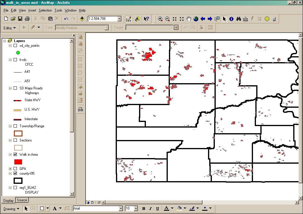
Each summer, field crews continue to add to this inventory by mapping invasive weed areas on individual GPAs. In 1999, SDGFP treated more than 1,080 acres of invasive species on wildlife division lands in Region 1. In 2002, SDGFP crews treated 887 acres of invasive weeds, which represents an 18 percent reduction over the previous three years. With ArcGIS, the spread or decline of invasive weeds can be monitored on an annual basis allowing for more efficient control methods, which saves time and resources. ArcInfo software's ArcGRID and ArcTIN have proved invaluable with invasive weed management. By analyzing preferred habitat of these plants in the field, a raster model was made based on certain criteria such as slope and aspect, water availability, cover types, and road density. Because seeds can attach to tire treads, a new infestation is commonly found along road ditches. This model allows managers to predict where the next infestation may occur. This same type of model was also applied to the introduction of a new bighorn sheep herd. The Black Hills encompass a region of approximately two million acres, and a major goal of the SDGFP is to have four, independent herds of bighorn sheep in this area. In 2000, a plan was devised to introduce a third herd in the southern Black Hills. Using ArcGrid and ArcTIN, a model based on water and forage availability, vertical relief with open spaces, and road density was designed to locate an optimal relocation site. ArcInfo Workstation, in conjunction with macros written using ARC Macro Language (AML), is a major tool in publishing the annual South Dakota Hunting Atlas. In South Dakota, more than 90 percent of the land is privately owned. This presents a problem for hunters who commonly comment about lack of areas to hunt. In 1988, the SDGFP started a program called Walk-In Areas (WIA). This program leases land from private owners that meets certain habitat criteria so that the general public can access this land for hunting. Part of the agreement between the SDGFP and private landowners is that these areas must only be accessible by foot traffic, hence the name. The WIA program has grown significantly from only 28,000 acres in 1988 to more than 900,000 acres today. Because the leases change annually, ArcInfo is used to create map booklets showing public hunting areas throughout the state. When the program first started, it took two people three months to compile all the lease agreements and create the paper maps. Today, one person using GIS accomplishes the same work in one month. Future TrendsBesides land management, the SDGFP encompasses three other subgroups: fishery management, game management, and law enforcement. In Region 1, land management was the first to use GIS and GPS technology. Now fishery management is starting to use GIS and GPS to monitor fish migration, water depth of lakes, and stream surveys. Game management has started creating an inventory of big game movements by using GPS units when crews track radio-collared animals. A significant problem for game management has come in the form of chronic wasting disease, a fatal brain disease found in deer and elk populations. Using ArcView 8.2, managers can now spatially track infected wildlife. All law enforcement officers are now equipped with GPS units in their vehicles to record areas of wildlife damage, boating accidents, and crimes. As more employees are introduced to GIS and GPS, more applications continue to present themselves. For more information, contact Dennie Mann, regional land supervisor, South Dakota Department of Game, Fish & Parks Region 1 (tel.: 605-394-2391, fax: 605-394-1793, e-mail: Dennie.Mann@state.sd.us), or visit www.state.sd.us/gfp. |