Spring 2003
Spring 2003 |
|||||||
|
|
|||||||
Mount St. Helens Recovery Followed With GIS |
|||||||||||
|
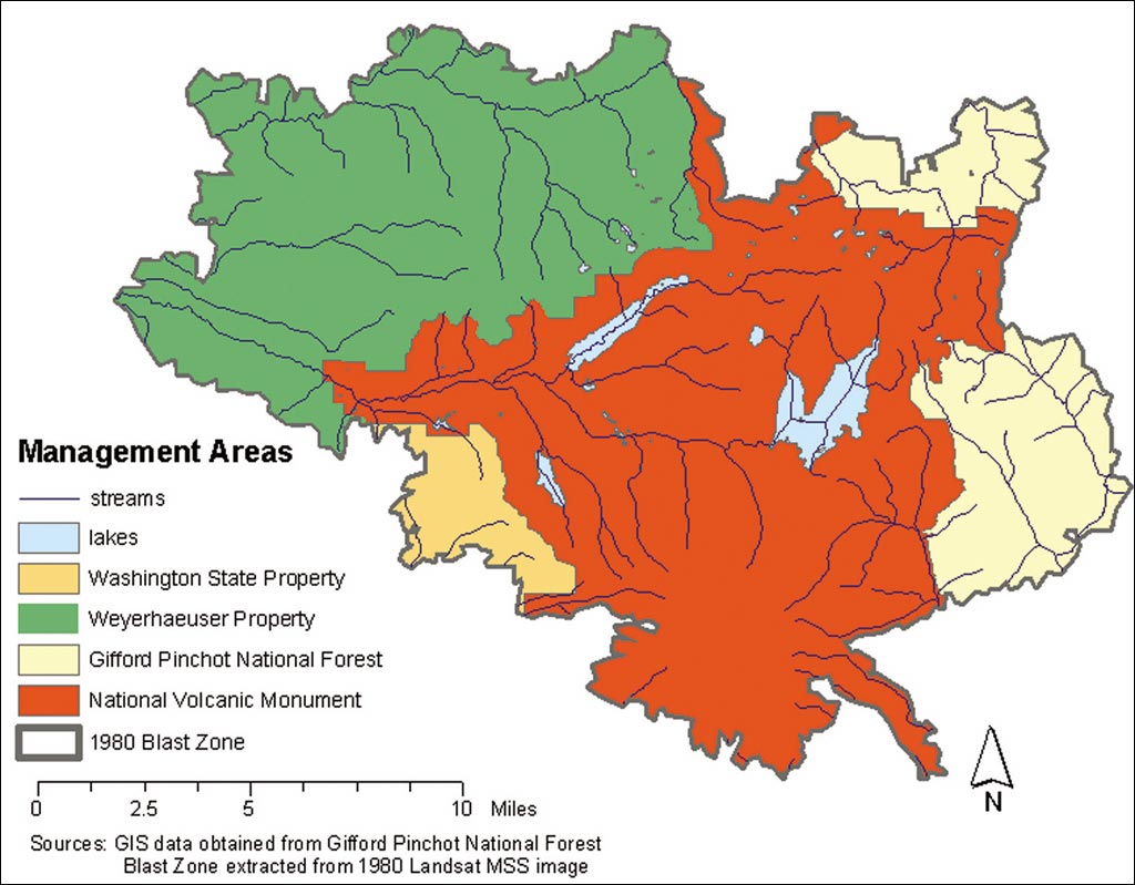
Situated in the Cascade Mountains of southwest Washington state is Mount St. Helens, the site of one of the most powerful volcanic eruptions recorded in the recent geologic history of North America. On May 18, 1980, at 8:32 a.m., a magnitude 5.1 earthquake occurred beneath Mount St. Helens, triggering a devastating eruption and landslide. The blast reduced the volcano's height from 9,677 feet to 8,364 feet, forming a large crater on the northern rim. The forest in the 620-square-kilometer (153,000 acres) blast zone was seemingly destroyed. Amid the destruction, exceptional opportunities for scientific observations, data collection, and the study of habitat recovery following a volcanic eruption were available. Dr. Luke Marzen, an assistant professor of geography at Auburn University, was a Ph.D. student at Kansas State University from 1997-2001. He began to study vegetation change and recovery in the Mount St. Helens' blast zone for his dissertation under the guidance of his major professor, Lisa M.B. Harrington, Ph.D., and professor and department chair, John Harrington, Ph.D.
According to Marzen, "At that time, most of the hundreds of previous vegetation change studies were localized ground studies exclusively focused in the National Volcanic Monument, a 445-square-kilometer (110,000 acres) area set aside to allow natural geological and ecological forces to continue with minimal disruption by human activity." Building on his previous graduate-level research at Ixtaccihuatl and Popocatepetl volcanoes in Mexico, and his advisors' research, Marzen's study examined vegetation change in the entire Mount St. Helens' blast zone from 1980 through 1998 and compared variations of change in relation to human and environmental influences. "Remotely sensed satellite imagery, image processing tools, and GIS analysis have allowed us to go back in time and study the blast zone at a 30-meter pixel resolution," continues Marzen. "We could not have performed an analysis of this scale solely using ground study techniques." For his dissertation, Marzen used ERDAS IMAGINE image processing software from Leica Geosystems and Esri's ArcInfo and ArcView software, plus the ArcGrid and ArcGIS Spatial Analyst extensions, in the remote sensing lab at Kansas State University. "I had previously used Esri and ERDAS products, as these are standards at most universities," states Marzen. "I have been very happy with the capabilities and performance of the software."
In 1998, Lisa and John Harrington used Landsat multispectral scanner (MSS) (80-meter pixel resolution) satellite imagery to analyze vegetation recovery in the blast zone from 1979 to 1992. They used ERDAS IMAGINE software to determine the Normalized Difference Vegetation Index (NDVI) in 1979 and calculated NDVI changes during the study time period. NDVI, the most commonly accepted and used vegetation index for more than three decades, has been utilized to assess plant growth, vegetation cover, and biomass production over time from multispectral satellite data. "Using image processing to derive NDVI, we visualized the recovering areas over the entire blast zone," states Lisa Harrington. "Luke Marzen expanded our study by using finer resolution data through 1998," continues Harrington. "He used ERDAS IMAGINE software to analyze Landsat Thematic Mapper (TM) satellite imagery (30-meter pixel resolution) and detected more variability in the landscape." Marzen also expanded his advisors' research by using Esri's GIS software in combination with image processing to determine the degree of vegetation change and develop spatial models to explain these changes. Esri's ArcInfo and ArcView were used to organize, create, and analyze spatial data associated with human and environmental factors that could contribute to vegetation recovery.
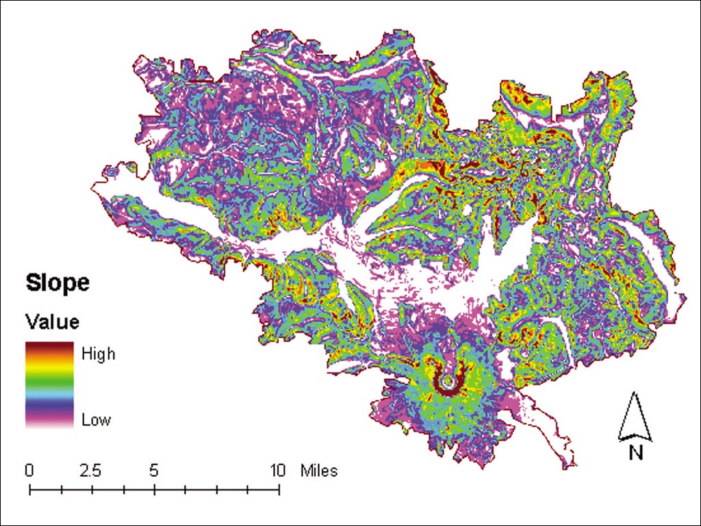
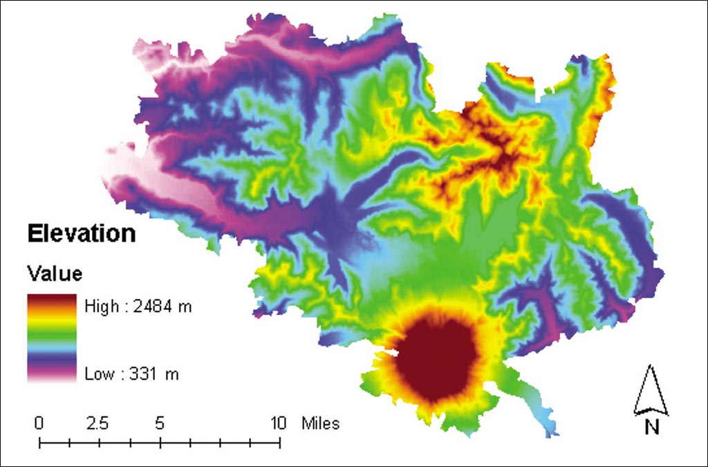
Marzen's analysis began with data collection from a number of sources. Landsat MSS and Landsat TM satellite images were obtained from the United States Geological Survey (USGS) EROS Data Center in Sioux Falls, South Dakota (edcwww.cr.usgs.gov/index.html). Stream centerlines, roads, management area boundaries, and digital elevation models (DEMs) for the blast zone were obtained from the Gifford Pinchot National Forest. Planted lands data, including species types such as Douglas fir and Noble fir, was derived from surveys provided by the United States Department of Agriculture (USDA) Forest Service and information provided by the Charles W. Bingham Forest Learning Center. Marzen obtained ash depth sample data collected by the USGS shortly after the eruption. Slope, aspect, and elevation images were derived from DEMs using ERDAS IMAGINE topographic analysis tools. Leica Geosystems helped Marzen develop a modeling tool that extracts random sample points from blast zone data and outputs a point coverage to be used for modeling. "Using this tool, I was able to use the point coverages to create new data sets from other GIS data," says Marzen. "I used the tool to create a point coverage from randomly selected pixels that could be used to gather and organize data from other coverages or GRID data sets. I could export this data into statistical software to develop models related to vegetation change. For instance, I assessed NDVI variability as a function of ash depth and found a negative relationship." Marzen developed 55 models, one for each satellite image and ownership management area in the blast zone in an attempt to explain the vegetation recovery. The four different major private and public land management areas in the blast zone are (1) private land primarily owned by timber and lumber company Weyerhaeuser Corporation, (2) Mount St. Helens National Volcanic Monument managed by the USDA Forest Service, (3) Gifford Pinchot National Forest managed by the USDA Forest Service, and (4) Washington State land managed by the Washington Department of Natural Resources. The management areas have different purposes such as profitability, conservation, and recreation. The management objectives of each area were shown to substantially influence vegetation recovery.
Marzen's study indicates that lower ash depth and steeper slopes were most influential in vegetation recovery in areas of natural regrowth such as the National Volcanic Monument. More vegetation survived and consequently regrew faster presumably because ash eroded faster on slopes. Vegetation located in higher elevations also experienced faster regrowth. Snow cover protected some vegetation during the eruption. Seedling establishment from either the seed bank in the soil or through the natural processes of seedling dissemination from areas unaffected by the blast also likely supported faster regrowth. In areas where human influences dominated, planted areas were the quickest to recover. Important factors in planted areas included safe accessibility (lower elevations near roads), aspect (warmer and moist areas), and the overall goals/objectives of management areas (i.e., maximizing profitability). Another major replanting issue was related to ash depth. If the depth was less than 12 inches, about the length of a shovel blade, employees from the Weyerhaeuser Corporation (an Esri software user) likely planted seedlings. Where ash depth was greater than 12 inches, the area was not initially replanted because site preparation cost was prohibitive.
"Mount St. Helens offers a great deal of information about ecosystem disturbance and recovery. Many studies have tended to ignore the human influence, a very important factor for recovery. The use of remote sensing and GIS provides the capability to consider both natural and human-influenced recovery over time," states Marzen. For more information on the Mount St. Helens study, contact Luke J. Marzen (e-mail: marzelj@auburn.edu), Lisa M.B. Harrington (e-mail: lbutlerh@ksu.edu), or John Harrington Jr. (e-mail: jharrin@ksu.edu). For more information about spatial solutions, call Leica Geosystems GIS & Mapping (tel.: [toll-free within the U.S.] 1-877-463-7327 or [outside the U.S.] 1-404-248-9000; Web: gis.leica-geosystems.com). Also see "The Eruption at Mount St. Helens and a Future for Ecosystem Recovery Studies." |