Spring 2003
Spring 2003 |
|||||||
|
|
|||||||
Remediation at Formerly Used Defense Sites
Munitions Cleanup Is Enhanced Using GIS |
|||
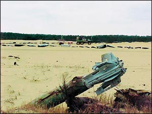
The application of GIS is now being utilized in remediation of munitions at formerly used defense sites (FUDS) located throughout the United States. FUDS were once used by the military as munitions testing and training areas and have since been investigated for cleanup and sold or transferred from the jurisdiction of the Department of Defense (DoD) to another entity. The Army implements the FUDS program through the U.S. Army Corps of Engineers (USACE). FUDS are those properties owned, leased, controlled, or used by the Department of Defense prior to October 1986. The U.S. Army Engineering and Support Center, Huntsville, Alabama (USAESCH), has been designated the center of expertise for unexploded ordnance (UXO) matters within the USACE. FUDS typically generate large amounts of data that must be shared among the public, clients, and project team members located throughout the United States. "The volume of data collected during ordnance and explosives (OE) geophysical surveys is large, and storage, access, and retrieval of this data can present a significant challenge," says Kimberlee Mulhern, project geologist with the U.S. Army Corps of Engineers, Omaha District. "Use of Web-based access to GIS permits access to this data in a timely and cost-effective manner for government quality assurance reviews." Through the use of geophysics, geospatial technologies, and Web site development, former military training facilities are being cleaned up by UXO specialists, using mapping and analysis done with GIS. Web publishing technology, in conjunction with GIS applications, now allows users to view aerial photographs, survey data, topographical data, global positioning data, and geophysical data collected from former military training areas where military ordnance items are located. Subsequent identification and removal of OE typically involve multiple organizations including government entities, private contractors, and technical experts. Through the use of GIS software tools, project coordination and execution are enhanced and simplified. GIS and Web publishing technologies serve as an effective management and communication tool when applied to OE projects. The ability to efficiently communicate and control information is essential to project success. A dynamic Web site called ProCommander (www.procommander.com), allows the coordinated efforts of all subcontractors to continuously communicate project status and results to the client and stakeholders who are interested in the work at a site. American Technologies, Incorporated (ATI), under contract with the U.S. Army Corps of Engineers, is conducting munitions cleanup at FUDS. Through the use of the ProCommander Web site, GIS technology becomes a successful and dynamic project and information management tool. Locating Anomalies and the Cleanup ProcessThe work required to safely locate, identify, and remove potentially hazardous OE items involves several steps. The area is initially surveyed to establish project boundaries and define a series of grids. After establishing the grids, UXO specialists perform a surface clearance to remove any potential OE hazards from the ground surface. Once the surface is determined to be free of OE hazards, the underbrush and small vegetation are removed in preparation for the geophysical survey. The geophysical survey will identify subsurface anomalies by using geophysical instruments and GPS. Geophysical anomalies, which may include underground OE or OE-related scrap, are then reacquired and investigated by UXO specialists. Additional field data (e.g., item description, depth, orientation) is recorded on a "dig sheet" and in a database for inclusion into GIS.
The GIS portion of the ProCommander site was constructed with ArcIMS software. All geospatial, geophysical, and document data is uploaded through ProCommander. The GIS data is combined, converted, and analyzed with ArcView. The information is then added into ArcSDE to handle the large-scale images and data sets for each project. Once loaded into ArcSDE, both in-house GIS professionals and visitors to the Web site can display data from the ArcSDE database. Web SiteGrids can be selected by positioning the cursor over the grid or from a drop-down menu that lists all grids alphanumerically by grid identification. Once a grid is selected, the user has the option of viewing and/or downloading raw and processed geophysical data, geophysical maps of the grid, and dig sheets used to identify anomalies to be investigated. Grids are also color coded on the maps to show phases of work completed and provide users a quick visual image of the project status. Anomalies are plotted on a map using a unique symbol to categorize the material (e.g., OE scrap, non-OE, quality assurance seed items, or no contact). When a user selects a grid on the map, a geographical representation of the grid is displayed with all anomalies shown by type (if they have been investigated). When a specific anomaly is selected in this view, information is displayed giving the user the item identification, its location and depth, a description of the item, etc. There are a number of query options that give the user the ability to display only those types of anomalies of interest. The project Web site can be accessed using standard Web browsers. This platform is capable of running multiple projects concurrently. The Web site is designed, developed, and customized for each project with no additional programming. The Web site is constructed to be intuitive and user-friendly and provide efficient access to large quantities of project-specific information and data. A unique Web page is dedicated to each project and serves as a central repository for all project-related information. It defines the project, scope, team members, stakeholders, and project status; presents progress toward completion; displays all anomalies identified as part of the removal effort; allows file sharing; and presents any other function related to that project. "The GIS/ProCommander Web site allows project team members in three time zones to quickly review and coordinate project information," says John Miller, project manager with the U.S. Army Corps of Engineers, Omaha District. As part of the Web page development, only selected information is available to various team members. This information includes project contacts, milestone schedules, meeting schedules, completed deliverables, status reports, key decisions, etc. The project information is configured both for secure access (i.e., log in, encryption, etc.) and public access. GIS and Web site development provide for improved document and file management. These tools provide a simple user interface to manage documents associated with the project. For more information, contact Matthew Norris, GIS specialist, ATI (e-mail: mnorris@atincorporated.com), or Jim Adams, ATI vice president and UXO operations manager (e-mail: jadams@atincorporated.com), or visit www.procommander.com on the Web. |
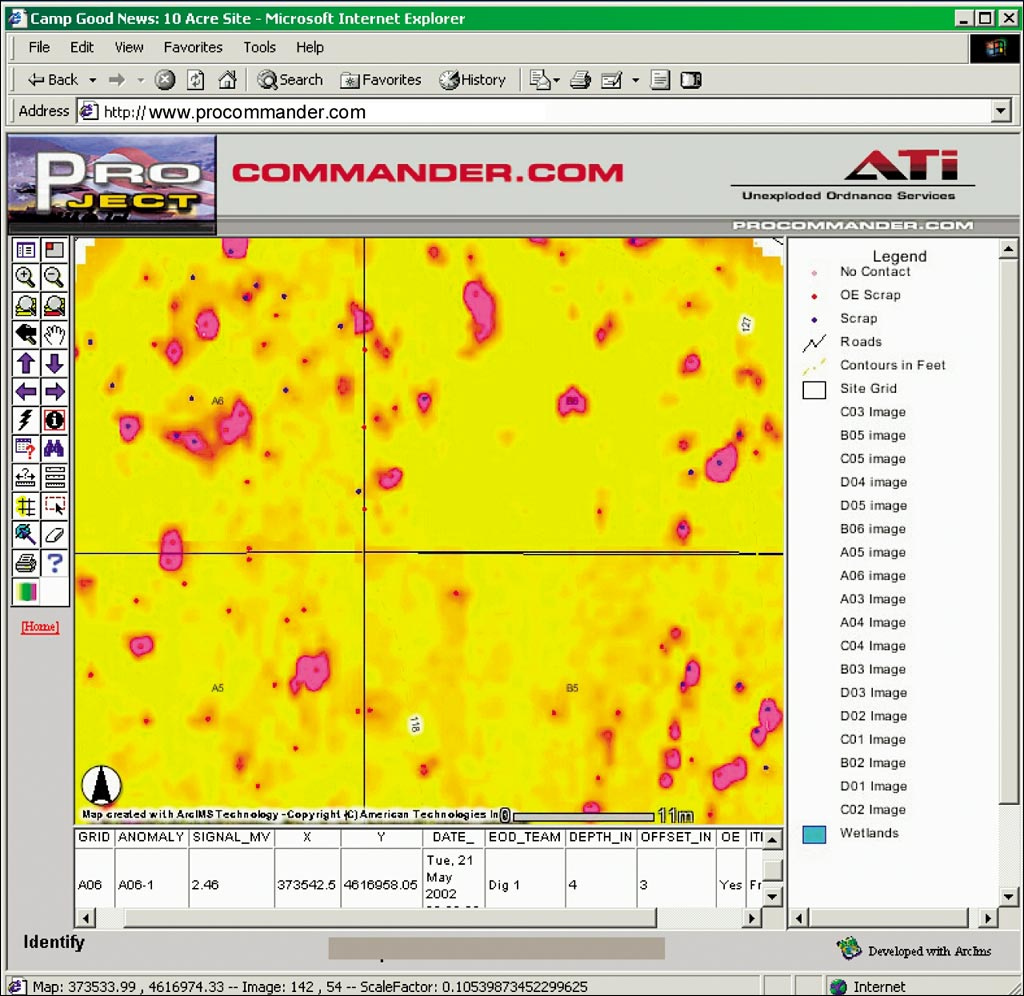
 Geophysical data is field analyzed, verified for quality assurance, and uploaded to the GIS Web site. Assigned users then view geospatial data of the site and the geophysical data recorded. General grid information, such as grid identification, area, and location, can be obtained by selecting the grid of interest. In addition, project documents and data on a broad spectrum or a specific OE anomaly can be reviewed through the GIS portion of the Web site developed using Esri's ArcIMS.