Spring 2003
Spring 2003 |
|||||||
|
|
|||||||
Esri Business Information Solutions
Providing the "Who" for GIS Analysis! |
|||||||
To effectively serve a customer, whether in the private or public sector, you have to know that customer's Business. This sounds obvious, doesn't it? However, in our current e-Business climate, which relies heavily on instant access to information through mobile communications and Web-based services, the client base may well be a moving target. When Esri created Esri Business Information Solutions (Esri BIS), it uniquely blended a leading demographic company with more than 30 years of experience and a well-deserved reputation for providing accurate and timely demographic data and services with Esri, the leading GIS technology company.
The New Esri BIS Web SiteEsri BIS has also recently launched a newly upgraded Web site (www.esribis.com) that integrates Esri's Internet technology with data and mapping from Esri BIS. This destination site supplies information and interactive features that serve Businesses of all sizes and types through flexible subscription plans.
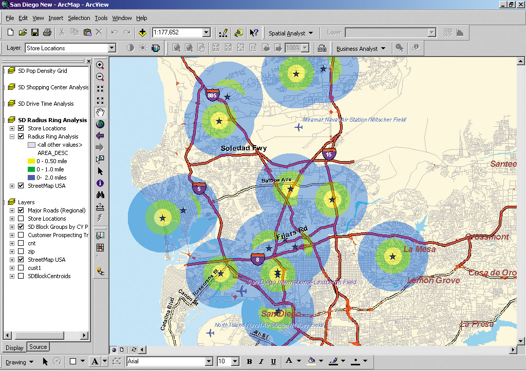
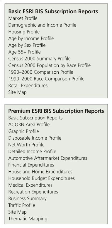
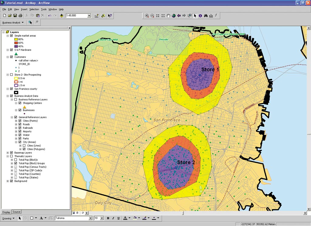
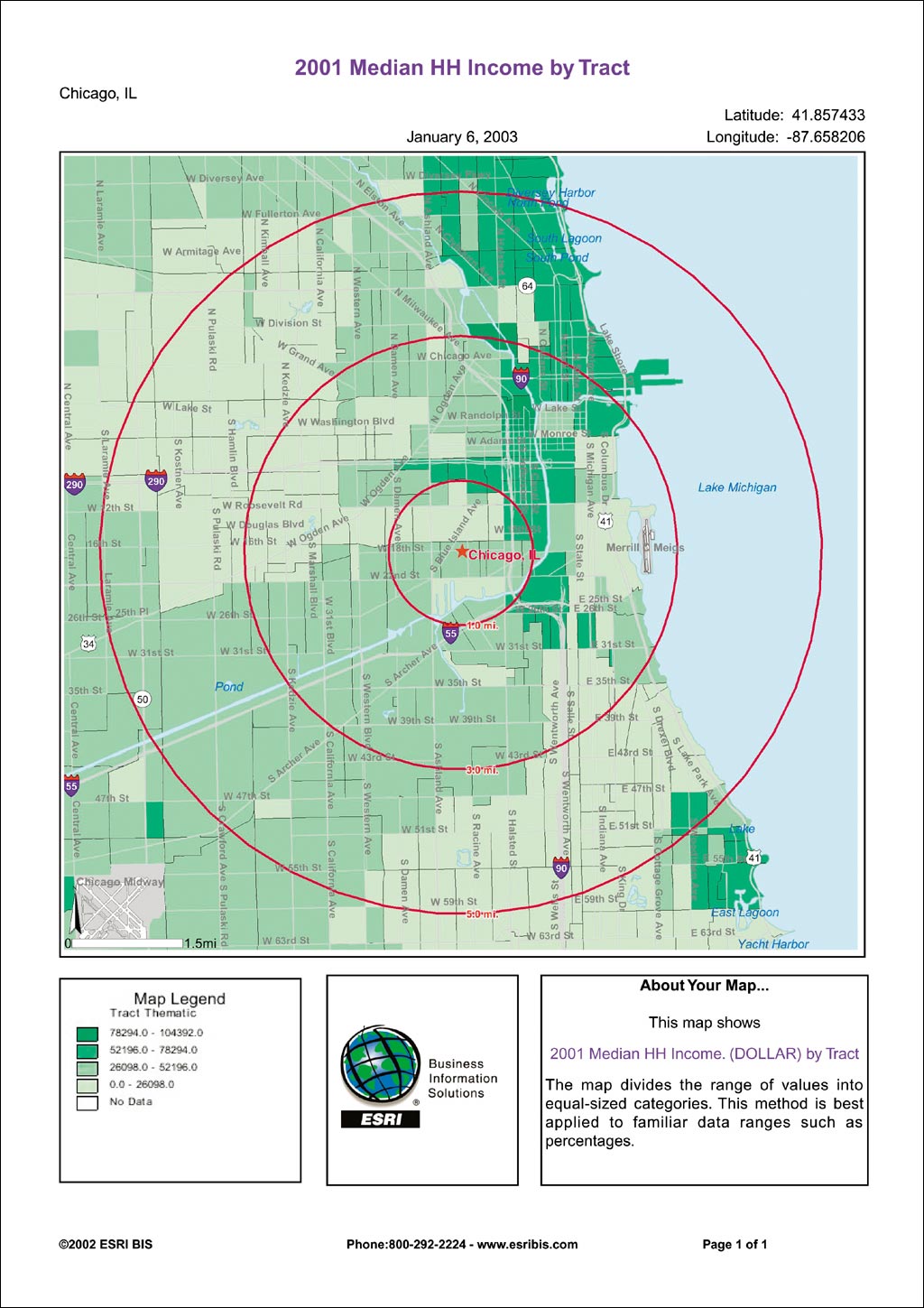
Both Esri GIS software and Esri BIS data work together to enhance a site's capabilities. Visitors to these enabled Web sites can quickly and easily access and retrieve data, visualize data in map form, and analyze data for critical decision making. Users can now instantly access and map the industry's best demographic data, estimates, forecasts, and segmentation from the vast repository of Esri BIS databases. For $995 (U.S.) per year, the basic Esri BIS subscription allows users unlimited access to a dozen of the most widely used data reports and maps during the subscription period. Users can customize a basic subscription by adding additional reports and maps to the package. In addition to the reports and maps supplied by the basic subscription package, the premium Esri BIS subscription provides 15 additional demographic and Business data reports and thematic mapping for $2,500 (U.S.) per year. These additional reports include more demographic and expenditure data reports that can be used to create detailed demographic profiles and used for other marketing applications such as customer profiling, trade area analysis, site evaluation and selection, territory analysis, and competitive analysis. The premium subscription can be further customized with the selection of other data reports. Data and Services for Local Government
"While our targeted industries include the 'three Rs'-real estate, restaurant, and retail--as well as financial services, media, telecom, and the utility industries, local governments are also major users of our products and services," comments David Huffman, managing director for Esri BIS. For example, the city of Los Angeles recently worked with Esri BIS to enhance the city's online data set capabilities for iMapLA, a GIS application the city developed that was designed to provide easy access and display of city-related information and services to both its staff and the community via the Internet. Used in conjunction with Esri's ArcView Business Analyst software, the robust data sets and Business-related applications were perfect solutions for the internal analyses regularly done by the city's information technology staff. Concludes Huffman, "We believe that the Esri BIS data offerings and analytical capabilities of Esri's software provide a powerful combination for demographic analysis in both the public and private sectors. State and local governments can use our products to learn more about the types of people in their communities so they can provide better services, while economic development groups can benefit by being able to better define their communities for recruiting new Business opportunities. Commercial ventures must know their clients and prospects to offer better products, determine where to place branches, define their product offerings based on the resident and working population, and so on. Basically, we help our clients determine who their customers are and where they are located so they can better serve them." For more information, visit www.esribis.com. See also "Esri BIS Launches CommunityInfo Data Sets" |