Spring 2003
Spring 2003 |
|||||||
|
|
|||||||
Riverside and Los Angeles Counties, California, Help Their Citizens Protect Themselves With Megan's Law Web Sites |
|||
Riverside County, California
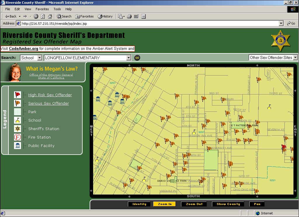
In accordance with California's version of the 1996 law permitting police authorities to disclose the presence of known child molesters in a community, the Riverside County Sheriff's Department recently developed and released its Sex Offender Location Map (www.co.riverside.ca.us/sheriff/) to county residents. This Web site gives residents of Riverside County information they can use to identify the location of sex offenders and better protect themselves and their children from them. Users can search specific neighborhoods, school zones, parks, and public facilities where registered offenders frequent and display these queries on a residential map. Locations shown are for offenders classified as either a serious risk (an orange flag) or a high risk (a red flag). Sex offender locations shown on the maps are approximate and are based on data provided by the U.S. and California Departments of Justice. The Riverside County Sheriff's and Transportation & Land Management Departments, along with Esri Implementation Services, worked jointly to develop an ArcIMS site capable of handling high traffic at low bandwidths, without compromising the public's access to all the information permitted under the current laws of the State of California and the California Department of Justice guidelines. The site was designed using ArcIMS 4, ArcSDE, and Esri's Implementation Services Department's Sex Offender Site Starter Solution. Several tools were created to optimize the site's ability to handle the number of hits expected including directly accessing ArcSDE pooling functions for handling such tasks as identify and zoom. The project included three weeks of development in Implementation Services' Application Development Center at Esri's headquarters in Redlands, California, and in its first three weeks drew more than 5 million hits. An interesting aspect of the Riverside County Web site is that it lets the public select any offenders of concern as well as find out the location of the nearest Riverside County Sheriff's station and obtain more specific information about the type of offense and other pertinent criminal history. This notification is key for the public not only to be informed but also empowered concerning the steps they need to take to protect themselves and their loved ones. For more information, please contact Lieutenant Steve Hill, Riverside Sheriff's Department (e-mail: shill@rc-lawnet.org) or Craig Morgan, Esri Implementation Services (e-mail: cmorgan@esri.com). County of Los Angeles, California, Posts Community Service Web SiteIn the United States, the 1994 Jacob Wetterling Act requires states to register individuals convicted of sex crimes against children, and Megan's Law, signed by President Clinton in 1996, gives states the discretion to establish criteria for disclosure of sex offenders to the public. In California, the law authorizes local law enforcement to notify the public about high-risk and serious sex offenders who reside in, are employed in, or frequent a community. Information about the offenders, including names and descriptions, is available via the Megan's Law Web application at viewing stations located within law enforcement agencies. Public Web sites cannot show the exact location or address of offenders. The Los Angeles County Sex Offender Locator (www.lacounty.info) gives people who live and work in Los Angeles County the ability to search for the general whereabouts of registered sexual predators living within the county by moving the icons representing the offenders off street segments and placing them in the center of census blocks. It also displays the number of offenders within a specified area and shows locations of the Megan terminals where the public can go to request specific information about serious and high-risk offenders in their community. Street routing directions to the selected Megan's terminal site are also provided. Enormously Popular SiteThe application is a collaborative effort among the County of Los Angeles Chief Information Office (CIO), the Chief Administrative Office, the Internal Services Department, and Esri Business Partner GIS/Trans Ltd. and implements ArcIMS, ArcSDE, and ArcGIS Desktop. Just before its launch on September 6, 2002, the locator site received extensive coverage in the local media, and within 12 hours of going live, it received 2.4 million hits--nearly four times the number anticipated. Because of the tremendous number of hits, some initial visitors did experience lengthy response times, according to John McIntire, associate chief information officer at the County of Los Angeles. "Esri played a critical role in helping to both diagnose and mediate the problem," he says. Because ArcIMS is a scalable, multithread system, additional servers were easily added without affecting the slowing functionality of the software. The County of Los Angeles had contracted with Esri Professional Services prior to implementing the site, and CIO, which provided project management, contacted the company for assistance in balancing the servers and optimizing the code. "Esri's Professional Services Division assisted in scaling the system to meet the demand and within a day after the launch of the site, they had overcome those technical difficulties," says Nate Johnson, Esri California regional office. McIntire says that after the initial overwhelming success of the site, visitation has reached a baseline, and CIO is moving to undo some of the servers that were added to handle the volume of first-time users. "Most people find the information they're looking for and don't have a need to return to the site regularly," he says. More FunctionalityThe Los Angeles County Sex Offender Locator is unique among the proliferation of local government Web sites that offer information on sex offenders, because it is one of the first to offer analysis to citizens. The application enables users to create maps that show the number of sex offenders located within a specified radius of a particular address. Another function displays maps showing the number of offenders and their locations in relation to schools, parks, and libraries. "Because of the tool sets we are using from Esri, we were able to provide much richer functionality, and we have a rich map layer," says McIntire. Transferable ApplicationWhile the Sex Offender Locator provides a valuable service to the public, McIntire says that it has also demonstrated the value of GIS as a tool for distributing information to the public. "The engine we are using is easily transferable to other social problems in the county. For example, if a county clinic closes, people will need to know where alternate sites are located. Instead of routing and radius searches for schools, parks, and libraries, we're able to do that for health and mental health facilities as well." CIO is also using the locator application as a model for developing a central resource and data repository for the county. "Instead of having duplicated databases and applications throughout the county, we can centralize them using single application engines. It's no longer cost-effective for each department to redundantly maintain databases and applications," says McIntire. For more information, contact John McIntire, associate chief information officer, senior IT consultant, County of Los Angeles (tel.: 213-974-2154, fax: 213-633-4732). |