Spring 2003
Spring 2003 |
|||||||
|
|
|||||||
The State of Utah Improves Efficiency of Its Geographic Information Database |
|||||
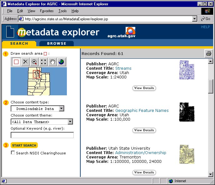
In the state of Utah, the Utah Automated Geographic Reference Center (AGRC) was established in 1981 and formalized by legislation in 1991 to promote the use of GIS. As part of its responsibilities, AGRC is the administrative steward and repository for Utah's State Geographic Information Database (SGID), the state's enterprisewide GIS data library. The SGID database consists of approximately 180 thematic GIS data layers that describe land use, demographic, environmental, infrastructure, historical, and political features throughout the state. These layers are provided free of charge to government agencies, the private sector, educators, and the general public via the Internet. In addition to providing access to the SGID's online clearinghouse, AGRC coordinates and participates in many cooperative data collection and maintenance partnerships involving federal, state, and local agencies. Dennis Goreham, manager of AGRC, states, "As the state of Utah moves toward an enterprise solution for all facets of the information technology field, managers are looking to the GIS implementation at AGRC as a successful model to follow." Since its inception, the SGID has benefited greatly from a multiagency, collaborative effort in building and maintaining the data layers that make up the SGID. Current cooperative efforts include an I-Team data development plan and a federal/state data sharing and integration memorandum of understanding. The breadth and depth of the SGID are dependent on this cooperation among federal, tribal, state, and local agencies. However, the distributed nature of the stewardship for individual data layers and the variety of source scales, together with the demands for near real-time download access to the SGID, present many ongoing complexities. To improve the operational efficiency and effectiveness of the SGID, AGRC set out to design a distributed system for storage, retrieval, and integration of large amounts of geospatial data that would also provide for a central access point to search and download GIS data sets from the SGID database. Enter MetadataTo this end, AGRC took into account that (1) Esri had responded favorably to a Request for Proposal, and (2) the State of Utah Data Processing Coordination Council had adopted Esri as the state GIS standard. The solution selected was ArcSDE 8.2 software using an Oracle database and the new metadata services available on ArcIMS 4.
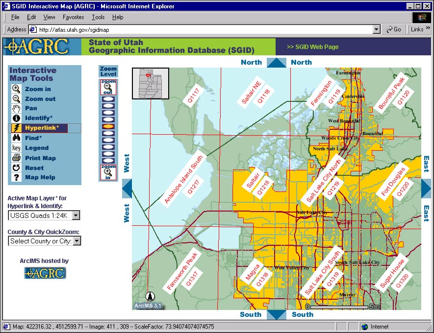
"At AGRC and throughout the state of Utah, if we all use the same software we can work and interact together," says Matt Peters, AGRC GIS analyst. The metadata can easily be authored using the ArcGIS ArcCatalog application and published to a metadata server where it can then be quickly searched by others. With ArcIMS metadata services, SGID users can use either ArcCatalog or the new Metadata Explorer browser to search for data. Simple "drag and drop operations" within ArcCatalog constituted the process of converting existing SGID data into ArcGIS feature classes, organizing these into feature data sets, loading the data into ArcSDE/Oracle, and associating metadata with the new feature classes. Since the Federal Geographic Data Committee (FGDC)-compliant metadata had been previously created and maintained for most of the SGID data sets, AGRC was able to take advantage of the search and thumbnail-style preview capabilities of the Metadata Server within a few days after the installation had begun. New Internet Mapping SitesIn addition to the SGID data layers available online through the Metadata Explorer site, AGRC has developed several custom ArcIMS- and Internet mapping-related sites. AGRC has developed an HTML interface for ArcIMS that is designed for use by the general public. This public interactive map interface is utilized for a number of state agencies' ArcIMS sites and the SGID interactive map (atlas.utah.gov/sgidmap), which provides links to the SGID data set download index. The SGID interactive map enables users to view and download, via links to the AGRC FTP site, all file-based GIS data sets available for individual United States Geological Survey (USGS) quads and counties within the state. AGRC also maintains an online map gallery (maps.utah.gov) of both static and dynamic maps pertaining to Utah. Jeannie Watanabe of the Chief Information Officer's office comments, "Integrating GIS into Utah state government to provide an enterprise resource for geospatial data is creating a tool that all state agencies can utilize and benefit from." AGRC also utilizes ArcIMS to host a Web-based mapping application (mapit.utah.gov) that is designed to enable the creation of simple, easy-to-use, Web-based maps of important locations in Utah. This site was developed as a distributed solution to a request by the Utah Chief Information Officer's office for every address on a state Web site to be linked to a map. Using the mapit site, state Web site authors can interactively build a map request URL, complete with custom map extent, label location, and label text, for use with their own Web sites. AGRC plans to use the multiuser editing features in ArcSDE to allow each data steward who contributes to the SGID to edit the data for which he/she is responsible and post updates to the ArcSDE database. This process will allow end users of the SGID to have access to the most current data as opposed to the yearly or semiannual update formats that were previously available. ArcMap Server will also be used to access live, dynamic data so users always have the most up-to-date information. For more information, contact Matt Peters at the Utah Automated Geographic Reference Center, 5130 State Office Building, Salt Lake City, Utah 84114 (e-mail: mpeters@utah.gov, tel.: 801-538-3168). To search for data, go to agrc.utah.gov and follow the link labeled "Geographic Data." |