Spring 2004
Spring 2004 |
|||||||
|
|
|||||||
ArcGIS 9 Offers a Complete System for Raster Data Management |
|
|
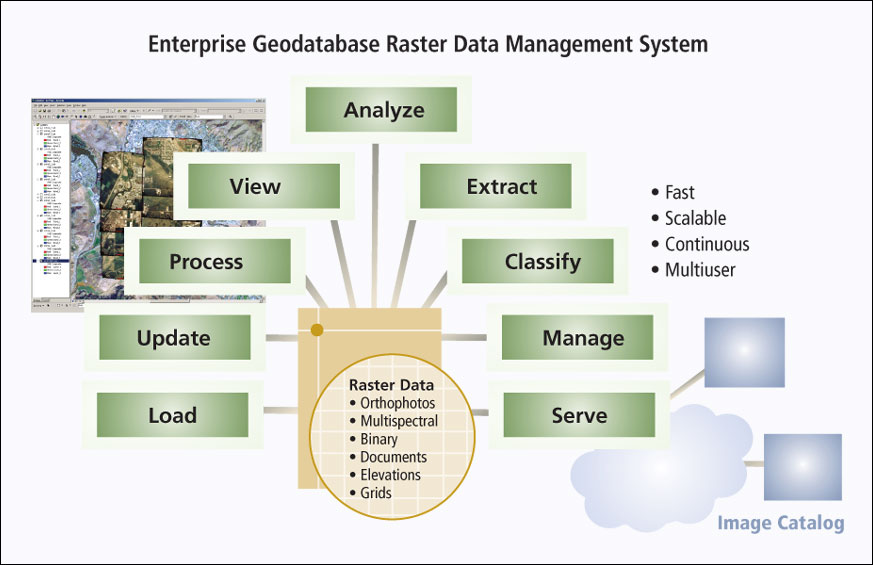
There is currently a trend within the GIS user community—ranging from federal agencies to other government agencies, private industry, and the public—toward more sophisticated uses of raster data, including land and natural resource planning, floodplain analysis, economic and community development, All of this adds up to a growing recognition that there is a need for a raster data information infrastructure that provides for improved storage and management and offers more efficient access and distribution. Today, organizations are searching for solutions that provide easy integration of raster data with vector-based data and for tools to effectively search these vast and growing collections of photos and images. The combination of ArcGIS 9 Desktop products with ArcSDE 9 and ArcIMS 9 provides an out-of-the-box solution to store, manage, update, access, analyze, and distribute collections of photos, aerial photographs, satellite images, and digital elevation models as well as other types of raster data such as scanned documents, maps, and CAD drawings. Organizations around the world have leveraged the ease of use and scalability of geodatabase (GDB) rasters to build and serve raster data sets many terabytes in size. ArcSDE is a core component of Esri's enterprise geodatabase raster data management system, enabling organizations to store their raster data and the related metadata in a relational database management system (DBMS) for fast, online, multiuser access to continuous raster data. The ability of an organization to store and manage the actual pixels and related metadata in a DBMS using standard relational tables means that now the same storage, indexing, and spatial search functions can be used to store, query, and retrieve both raster and vector data. Moreover, when an organization moves its raster data into a DBMS, it extends all of the DBMS tools for recovery, backup, security, fail over, and replication to the raster data collection. This, in turn, means that just as ArcSDE first enabled organizations to store and manage their vector data in the leading relational databases, including IBM DB2, IBM/Informix, Microsoft SQL Server, and Oracle, along with the rest of their core data, ArcSDE also offers open access and information technology standards to raster data. ArcSDE is unique in that it was designed from the ground up to store and manage large collections of raster data in a DBMS, providing a fast, scalable platform for multiuser access. ArcSDE provides support for quickly loading all raster data formats supported by ArcGIS Desktop; options for storing raster data with no compression or with data compression (recommended) using lossless, LZ77 compression or lossy, JPEG and JPEG 2000 compression; "pyramids" (a series of reduced resolution representations of each raster data set) for improved display performance; and caching for fast redisplay. ArcSDE 9 provides the ability to quickly update imagery already stored in the database with the use of partial pyramid updates. In addition, ArcSDE 9 with ArcIMS 9 provides a solution for distributing raster data over Intranets and the Internet, and it also provides the core building blocks for creating e-government and e-commerce spatial distribution portals. For smaller organizations, or for those without a requirement for fast multiuser access to the raster holdings, a personal GDB can also act as a raster data repository. Data stored on disk is referenced by the GDB tables to create a seamless data experience. In cases where disconnected editing is being used, raster imagery can also be checked out of the enterprise GDB along with the vector data to a personal GDB. Even when there is not a requirement for the actual raster data to be stored in a DBMS (e.g., with historic aerial photos or unprocessed satellite image collections that are stored using binary files, near-line storage, or tape silos), the combination of ArcSDE with ArcCatalog, the ArcGIS Desktop application, and the ArcIMS Metadata Server provides powerful tools to allow organizations to create, manage, and publish metadata along with subsampled "thumbnail" images. They can also create image footprints that enable users to quickly search large raster data collections based on any combination of geographic extent, content type, data format, or keyword. In summary, ArcSDE offers an approach in which raster data can now be stored and managed in a DBMS along with an organization's vector and other core data. The combination of ArcGIS 9 Desktop with ArcSDE 9 and ArcIMS 9 is positioned to provide the core infrastructure needed for raster data management. New functionality available with the latest release makes it faster and easier than ever to get started with a fast, reliable repository of raster information. For more information, visit www.esri.com/arcsde, call Esri at 1-800-447-9778, or call your Esri regional office (to locate your regional office, visit www.esri.com/usa). Outside the United States, contact your local Esri distributor; see www.esri.com/international. |