Spring 2004
Spring 2004 |
|||||||
|
|
|||||||
150 Years of Data Covering Six States Becomes One Distributed Biodiversity Database
In Denver, Colorado, Two Natural History Institutions Merge Their Collections |
|||
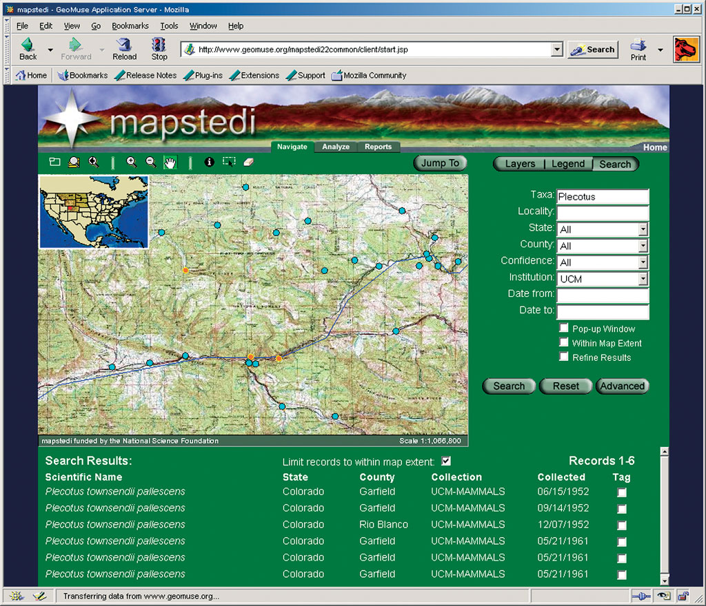
The Mountain and Plains Spatio-Temporal Database Informatics Initiative (MaPSTeDI) is a three-year collaborative research project between the University of Colorado Museum-Denver Museum of Nature and Science and the Denver Botanic Gardens to convert their previously separate natural history collections data into one distributed biodiversity database. This project, which currently covers a six-state region, including Colorado, Montana, Nebraska, North Dakota, South Dakota, and Wyoming, provides the public and researchers access to biodiversity data collected over the last 150 years via an online mapping application. Natural history collections are baseline documents of past and present biodiversity. As the value of biodiversity and the threats to that diversity are better understood, many researchers have begun to leverage natural history collections information for research, management, and education relating to biodiversity and biodiversity change. Online mapping applications offer users the ability to visualize and analyze collections data along with other environmental spatial data layers, providing multiple audiences access to this source of biodiversity information. The MaPSTeDI project focuses its efforts on the southern and central Rocky Mountains and adjacent plains because of the partner institutions' collections strengths in this area. The Rocky Mountains and plains contain extraordinary biological diversity and a wide variety of biomes including alpine tundra, woodlands and savannas, conifer forests, grasslands, and major rivers. Museums are important warehouses of baseline biodiversity data because of their long history of collecting, recording, and storing specimens. MaPSTeDI researchers used Esri's suite of ArcGIS tools, including ArcGIS Desktop (ArcInfo), ArcSDE, and ArcIMS, to create an online mapping application to visualize, explore, and analyze biodiversity data from the three partner institutions. Esri's software was selected over other vendors and open source alternatives because it was able to meet a wide range of institutional needs and because of Esri's ongoing product development plans. To make MaPSTeDI data available, a number of steps were required to compile the natural history collections' data sources and formats into a common data model that could be accessed across distributed servers. These steps included georeferencing the natural history collections data, converting the collections data from a variety of database formats and data models into a standard geodatabase based on a common coordinate system and datum, and developing an Internet-based mapping application to access the data in a distributed architecture. While most researchers today are often equipped with a GPS unit and record geospatial coordinates while collecting specimens in the field, this is not typically the case with historical collections data. In the majority of cases, historical collections data needs to have geospatial coordinates assigned based on descriptive location information provided with the record. The process of assigning coordinates to historical collections data is called retrospective georeferencing. For the MaPSTeDI project, a team of undergraduate and graduate students worked diligently to locate these historical records using the U.S. Geological Survey (USGS) Geographic Names Information System and National Geographic's TOPO! map software. Once the data was georeferenced, the next step was to load the data into a geodatabase. The geodatabase used in MaPSTeDI is based on the Darwin Core version 2 data model that was jointly developed by the Biodiversity Informatics Research Center at the University of Kansas and the Museum of Vertebrate Zoology at University of California, Berkeley. A data conversion application was written using ArcGIS Desktop and Visual Basic for Applications. This program converted the collections data from comma-delimited text files and loaded the data into a geodatabase in ArcSDE using a consistent geographic reference system and datum. Next, an online mapping application was developed using Java and ArcIMS. The online mapping site, called GeoMuse (www.geomuse.org), provides a portal to tens of thousands of specimen data collected over the last 150 years. Data from the University of Colorado Museum and the Denver Botanic Gardens is stored in a local ArcSDE database, while data from the Denver Museum of Nature and Science is retrieved in real time from an ArcIMS server. In addition to traditional online mapping functionality, GeoMuse provides users with the ability to generate a wide variety of reports; download the data as Esri shapefiles, Xcel spreadsheets, or text files; analyze the data by generating distance matrixes between selected points; and access species abundance values across the landscape. By providing greater access to natural history collections data, MaPSTeDI provides the public, researchers, and nongovernmental organizations with a new data resource useful for biodiversity research and land management planning. Tyrone Guthrie, a GIS specialist with The Nature Conservancy's Rocky Mountain Division, says, "The ability to access museum collections data in a spatial format would be an invaluable enhancement to ecoregional planning efforts at The Nature Conservancy." For more information, contact David Neufeld, GIS specialist at the University of Colorado Museum (e-mail: david.neufeld@colorado.edu) or Robert Guralnick, principal investigator for MaPSTeDI and assistant professor in the University of Colorado Department of Environmental and Evolutionary Biology (e-mail: robert.guralnick@colorado.edu). This project was made possible by a grant from the United States National Science Foundation. |