Spring 2004
Spring 2004 |
|||||||
|
|
|||||||
In Tuscany, Italy, Old Style Vineyard Management Meets New Style Precision Farming |
|||||||
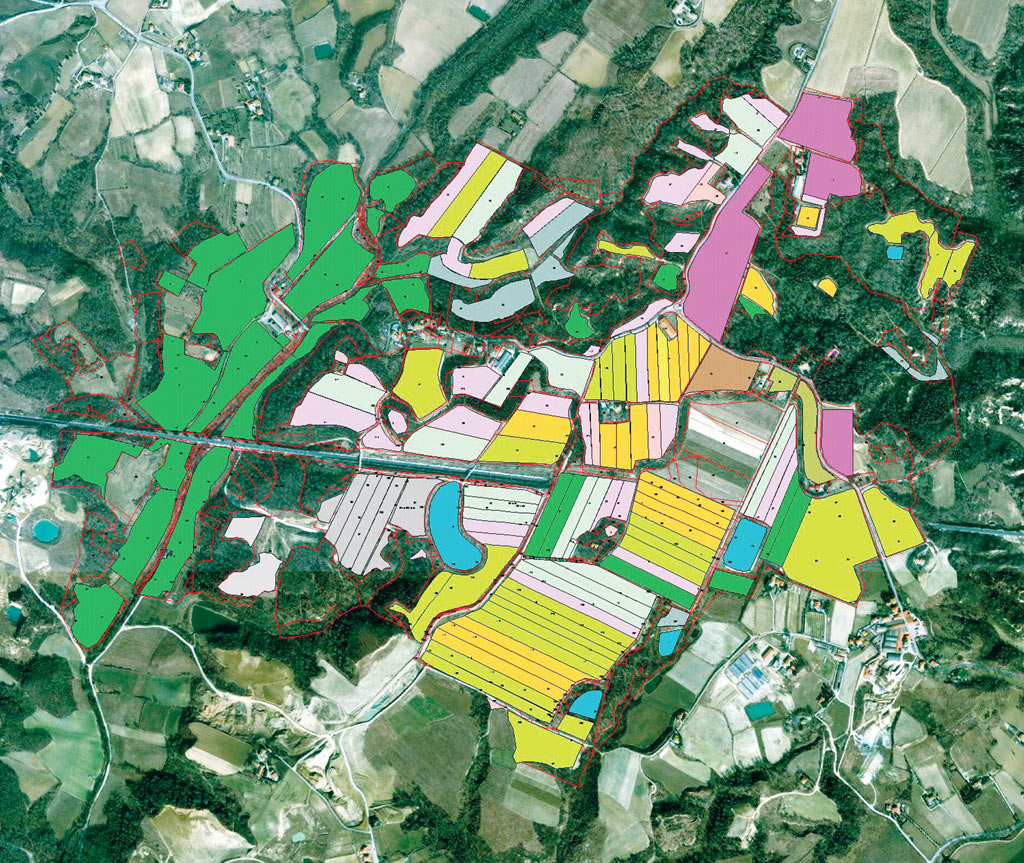
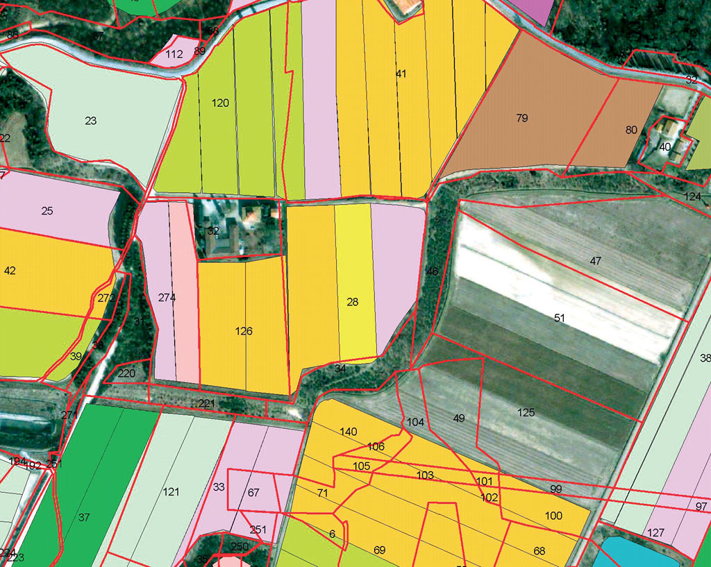
On the hills of Tuscany, Italy, Etruscans and Romans, the Granducato and Medici families, and numerous noblemen throughout the following centuries created one of the most recognized wine producing areas in the world. Their experiences formulated vineyard science into an art. Vineyard science is more ancient than millennia-old cartography, but new technology has merged these two ancient studies and brings high yields to the world's most traditional vineyards. Tenuta Agricola Vitereta di Bidini Annita & c.s.s., located in the wine grape growing region of Tuscany, is using GIS for precision vineyard management. This farm is part of the Tenuta Vitereta estate. In 1973 the Bidini and Del Tongo families purchased the farm and Villa Clerici–Bernetti, located inside the estate, from the Countess Rimbotti–Castellani. Marcello Bidini, who is the director of the farm, invests his resources and energy toward retaining the traditional Tuscan agriculture. The farm includes 450 hectares with a cultivated area of 230 hectares. In this mild Mediterranean climate, at an elevation of 260 to 270 meters above sea level, the farm flourishes in its production of grapes, grain, sunflowers, olives (for extra virgin oil), medicinal herbs, corn, and poplar wood. The vineyard area of 42 hectares produces cabernet, sangiovese, merlot, and chardonnay grapes for an annual wine production of 1,500 to 1,800 hectoliters. Improving the yield of the farm remains, as it has for centuries, a primary goal. Therefore, Bidini was interested in using GIS technology to help him better manage the farm. Experience Can HelpBidini understood that GIS could be used to integrate various types of data in solutions for analysis, planning, management, etc., and to offer informative maps and related reports. This GIS background was the result of his also being part owner of Del Tongo Industries S.p.A., an Italian-based producer of kitchens and home furnishings with approximately 700 points of sale in Italy, 100 in Europe, and 20 in the rest of the world. In this capacity, Bidini had worked with GIS2000 S.r.l., a GIS consulting company headquartered in Torino, Italy, which had developed an ArcView application to manage and monitor Del Tongo's sales network. After working together on this project, Bidini asked GIS2000 to develop a farm management application that could help him manage and plan the Tenuta Vitereta farm.
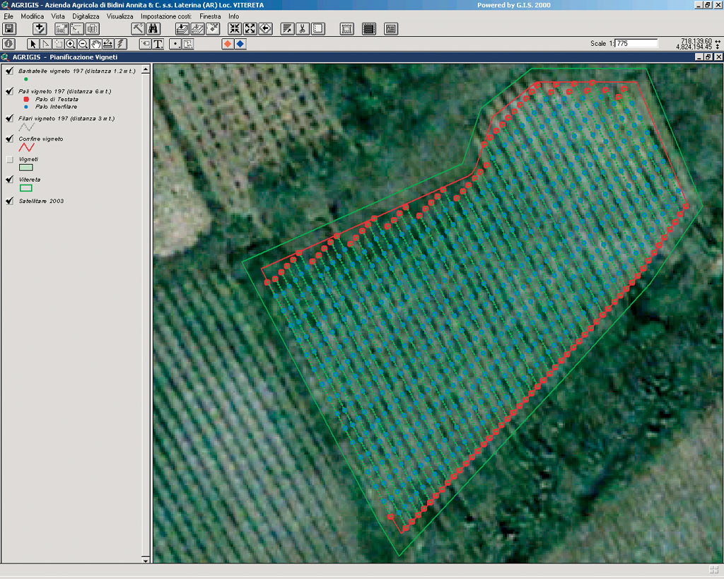
The first goal was to develop a solution capable of calculating government subsidies and labor costs and to help farmers with management activities. GIS2000 devised a GIS application that improves data quality and enables queries of government subsidy information. This AgriGIS application offers a strategic method for incorporating numerous types of data needed to improve farm management. AgriGIS was developed as an ArcView 3.2 project. AgriGIS comprises two views, one designed for managing farmland (Field/Vineyard Management) and one for planning vineyards (Vineyard Planning). The vineyard planning functions were developed for simulating new vineyards and estimating the costs of the installation to supply the user with an effective support tool for strategic planning. Cadastral cartography, remote images, and field data were integrated into ArcView to create a basemap for the project. The first view provides access to all capabilities related to field and vineyard management. It can search for and display data related to fields (area, crop, owner, labor costs, etc.) and vineyards (grapes, growing method, distance between rows, distance between seedlings, etc.) through dialog boxes. In keeping with the original intent of AgriGIS, the application can also create and export tables containing the data required for requesting government subsidies. In addition, the Field/Vineyard Management view also allows the user to automatically calculate labor costs and display them, create and print thematic maps for the various crops and property, and create printable reports for each field or vineyard. Establishing New VineyardsSpecifically designed for the farm's grape growing activity, the Vineyard Planning view provides access to a tool that simulates the installation of new vineyards and estimates the installation costs. The considerable capital necessary to develop new vineyards requires that these choices be evaluated very carefully as they can greatly influence the economic life of the grape growing operation. The choice of materials, the various technical and agricultural solutions necessary to allow for the use of machinery, the distance between the rows, the growing method, etc., are all important aspects in the planning of new vineyards or in the renovation of existing vineyards. AgriGIS software's Vineyard Planning application was developed to plan vineyards, which utilizes the cordone speronato, or spurred cord, growing method, one of the most widely used methods as it allows for the use of machinery to carry out much of the labor involved in grape growing. This system provides for optimal foliage exposure to the sun, making the grapes luscious and sweet.
Simulations of new vineyard installations can be carried out by choosing the distance between the rows, the distance between the seedlings, the distance between the posts, the minimum length of the rows, and the noncultivated distance at the margins of the vineyards (used for the passage of machinery). After having inserted all of the requested parameters, the application draws the vineyard, showing the external posts, the internal posts, and the seedlings. The system automatically eliminates rows under a certain length and is able to draw vineyards with complex geometrical forms. It was particularly important that the system be programmed in such a way that it could draw the rows taking maximum advantage of the available space. It was also important that the integrity of inserted data and the general prerequisites of the growing method be maintained. When the design is completed, an ArcView dialog box displays the main values of the new vineyard: area, distance between rows, distance between posts, number of rows, number of posts, total length of rows, distance between seedlings, number of seedlings, density, etc. Through the same dialog box, it is possible at this point to choose the materials (grapes, posts, steel wires, etc.) necessary to install the vineyard, and the system will provide an estimate of the cost of the installation. Future developments will include the use of GPS for field survey and data updating as well as an ArcPad solution to move from a desktop GIS to a field GIS. GIS continues to be an important management tool at the Tenuta Agricola Vitereta estate. Because of the success of this pilot project, the farm's managers are now considering the use of GIS in other areas of farm management such as irrigation planning. For more information, contact Alessandro Forlin, managing director, GIS2000 (e-mail: forlin@gis2000.it, tel.: 39-011-438-60-26). |