Spring 2004
Spring 2004 |
|||||||
|
|
|||||||
Jordan Department of Antiquities Manages Archaeological Sites With GIS |
|||
|
By Stephen H. Savage, Ph.D., Department of Anthropology, Arizona State University, Tempe, Arizona
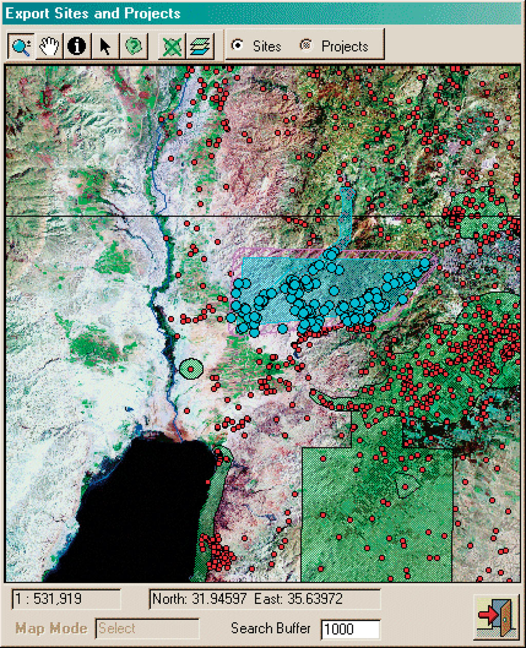
Between Syria to the north, Iraq to the east, Saudi Arabia to the south, and Israel to the west, the Hashemite Kingdom of Jordan is located at the crossroads of ancient and modern Middle Eastern civilizations. The kingdom lies in the heart of one of the most historically important and intellectually intriguing regions on earth. For millennia, Jordan has borne witness to the rise and decline of civilizations. Cities, such as Pella, grew here in the Bronze Age; the Iron Age kingdoms of Edom, Moab, and Ammon were absorbed by a succession of empires that waxed and waned across the region—Assyrian, Babylonian, Persian, Greek, Nabatean, Roman, Byzantine, Islamic, and Ottoman civilizations left remnants of their passing in Jordan's rich archaeological heritage. Today, lacking large oil deposits, a significant part of Jordan's foreign income is from archaeological tourism. There are more than 10,000 known sites, and it's been estimated that there may be as many as 200,000 undiscovered archaeological sites in Jordan. Many known sites are being destroyed by rapid urban growth and the expansion of agricultural land. The Department of Antiquities of the Hashemite Kingdom of Jordan (JDOA) is responsible for efforts that discover, monitor, preserve, and develop archaeological sites within the kingdom. In the face of a rapidly expanding urban population and developing infrastructure, the demands for timely information about archaeological sites have threatened to overwhelm JDOA staff. In the early 1990s the Jordan Archaeological Database Information System (JADIS) was compiled and edited by Dr. Gaetano Palumbo under the auspices of the American Center of Oriental Research (ACOR) Cultural Resource Management Program, sponsored by the U.S. Agency for International Development. Palumbo's original effort resulted in the encoding of more than 8,600 archaeological sites in a FoxPro relational database implemented by CDG Management and Associates, of Amman, Jordan. This original JADIS database, however, did not offer map or GIS support. JADIS Database RebornNow a new version of the JADIS database has been developed and installed at JDOA and ACOR, under the auspices of a Senior Fellowship from the National Endowment for the Humanities and ACOR. The new version supports many additional functions, including archaeological projects, information on permits and loans, condition reports, and digital photographs. This is the result of the JADIS sponsors evaluating the available applications and choosing MapObjects development software from Esri. An embedded MapObjects control was built into the new database graphic user interface to support GIS functionality within the system, making it easy to see and query the distribution of sites and projects against a background of satellite images or 1:50,000-scale topographic maps. The addition of map-based support to the system makes it much easier to use, both as a research tool and a planning tool, for cultural resource management purposes. Development projects can be planned to limit their potential impacts on known archaeological sites because the actual "footprint" of a planned development can be searched; the area of potential effect can be adjusted if significant archaeological sites will be impacted by the project. This significantly enhanced version of the JADIS system uses a MapObjects control embedded in a Microsoft Access front end to provide an interactive GIS/Access user interface; data tables are stored in a Microsoft SQL Server Desktop Engine database. The program now supports Digital Chart of the World layers, satellite images at 28 m and 10 m resolution, and 1:50,000-scale topographic maps of Jordan. These are delivered as background images and automatically load and unload as needed; the effect is a seamless quad sheet or satellite image coverage of the entire country. Users can query the data tables or the map. Irregular polygons can be drawn on the map and buffered to a user-specified distance, and all the sites that fall within that region can be retrieved instantly and sent as printed reports. An export/import function lets JDOA staff export a subset of the main JADIS database to an external file in Microsoft Access format. These functions make archaeological survey work and reporting to JDOA a lot easier, because all the records currently in the main JADIS database from an area of interest can be exported in the JADIS format and can be read by a Microsoft Access stand-alone data entry program. The exported subset can be modified, and new sites can be entered as they are discovered. At the end of a field project, the JDOA staff can reintegrate the exported database with the main JADIS system with the import function. The MapObjects control automatically puts new sites on the map as they are imported. Providing Real-Time AnswersThe program allows photographs and documents to be attached to sites and site visits, and it allows reports to be attached to projects, permits, and loans. This lets the system be used to monitor changing conditions at any site and document them with photographs and detailed reports. The importance of the JADIS database system cannot be underestimated. Palumbo, who is now the director of Archaeological Conservation for Africa, Europe, the Middle East, and Central Asia at the World Monuments Fund, stresses, "With the development of GIS in all sectors of public facilities in Jordan, from infrastructure to urban development, JADIS can provide real-time answers to engineers and site planners so that unnecessary destruction of cultural resources is avoided, and archaeological sites can become part of a development process instead of being considered obstacles to it." The MapObjects control powers an easy-to-use interface, ensuring that JDOA and archaeologists conducting research in Jordan will use it extensively. As a planning tool, the JADIS database allows much more detailed archaeological searches, especially when combined with topographic map support. Searches based on topographic maps can easily outline the impact area of a proposed new highway, for example, and quickly identify any known sites that will be impacted by the construction. The identification of impacted sites is only the first step in a process that can include the preservation and development of important archaeological resources for touristic purposes. The system's capability to conduct attribute queries and produce distribution maps will greatly enhance the ability of researchers to address any number of questions related to settlement patterns and human impact on ancient and modern environments. The JADIS Web site can be reached from archaeology.asu.edu/jordan by clicking on the JADIS button. The Standalone Data Entry Program can be downloaded along with satellite images, topographic maps, and Digital Chart of the World data for Jordan and the southern Levant. For more information and breaking news of an expanded JADIS model for Iraq, contact Dr. Stephen H. Savage, Arizona State University (e-mail: shsavage@asu.edu). |