Spring 2004
Spring 2004 |
|||||||
|
|
|||||||
More Accessible Legal and Natural Resource Information
Land Information British Columbia Uses GIS to Improve Land Governance |
|||||
|
Imagine a strong and vibrant provincial economy. Imagine a supportive social infrastructure. Imagine safe, healthy communities and a sustainable environment.
The government of British Columbia, Canada, is focusing on these three ideals, making them the cornerstones of its vision of British Columbia as a prosperous and just province whose citizens achieve their potential and have confidence in the future. Now imagine enabling and engaging the participation of individual citizens and the private and public sectors in achieving this vision. What if these groups had simple, direct, and open access to integrated social, economic, and environmental information? What if everyone could see how they fit into the larger social, economic, and environmental fabric of British Columbia? What if everyone could see the interests of others. We could see the potential impacts of our decisions. We could act together with certainty and responsibility, mindful of our common good. In 2000, the government of British Columbia took the first steps toward the realization of this vision by setting in motion a new direction for the governance, management, and delivery of corporate land and resource information services under a single information service initiative—Land Information British Columbia (BC). The Land Information BC business delivery model consists of the following key components:
Land Information BC was designed to improve the management, access, and value of landownership as well as legal interest, geographic, and natural resource information for a range of clients. Guiding principles include connecting government, industry, business, academia, and citizens to meet their needs and preferences through easy and simple access (client focused); developing solutions collectively among public, private, nonprofit, and research partners on the basis of skills, experience, and expertise; and focusing on cost-effectiveness, innovation, value, and results. Land Information BC meets these designs and principles by providing integrated resource and land information, services, and value-added products to the resource sector businesses, industries, academia, governments, and the public in support of sustainable development and sound stewardship of our resources. Critical features are single window access to this information, interactive e-mapping services, and value-added science-based products. Changing the Delivery ModelNow in its third year, Land Information BC has changed the model for the delivery of land and natural resource information.
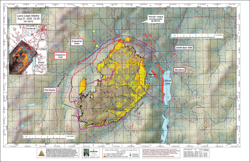
Historically, land and resource allocations and stewardship were confined to a single agency mandate (e.g., Ministry of Forests) with a narrow spectrum of stakeholders (e.g., forest companies). Hence, decision making involved fewer challenges and was based on limited information, simpler models, and technology that was relatively simple. In the 1990s, new stakeholders (e.g., tourism operators, First Nations) with competing interests began to challenge existing land use; thus decision making became more complex. These competing interests on the land base created significant controversy. "The studies that we conducted during that time," points out Don Howes, executive lead of the project from 2000 to 2003, "indicated that the land and resource information management programs were fragmented across government and were not keeping current with this change. Furthermore, increased demand for more information and the complexity of collecting, managing, accessing, and analyzing numerous disparate land and resource data presented difficult challenges requiring the province to change its business activities, organization, and relationships. As a result, most land and resource information activities (e.g., inventory, data management, analysis) were consolidated into a single agency and Land Information BC was born." Current efforts are centered on information integration to improve the quality, relevancy, management and access to information and the implementation of services including the Land Information BC portal. "Better access to science-based information products enables all levels of decision makers to make faster, better, and more informed decisions," says Howes. Status of Land Information BC's Key ComponentsGeographic Reference Information—Updating of the complete provincial coverage of 1:20,000 scale baseline mapping of digital topographic, aquatic, and man-made features is 60 percent complete. The geographic reference information has been enhanced with the implementation of a short-term solution to digital image management and an e-service application to aerial photographs and satellite images; a networked provincial stream system (70 percent complete); and a provincial digital road network for linkage with GPS to service 911 response, vehicle navigation, and routing. Land and Resource Registry—An integrated registry to manage and provide the accurate and timely land and resource status of all legal interests in Crown as well as private land and resources delivered through Web-enabled services is in its third year of development. The first increment of the registry is currently underway, bringing together all types of legal interest data to support the resource-based industries in the northeast corner of the province. In addition, an electronic submission system for land titles and land survey will be complete by spring 2004. Land and Resource Warehouse—The land and resource warehouse has been implemented; to date 37 distinct data sets, organized into 18 schemas with 239 physically implemented layers, have been loaded. The warehouse runs ArcSDE 8.3 and Oracle9i on a UNIX platform. According to Gary Cooney, Information Management director, "We selected these applications because they best met the requirements of the high-production environment required for Land Information BC, and the ministry has been a longtime user of Esri products." Land Information BC Portal—Significant efforts have also been directed at the Land Information BC portal to improve delivery of information services including e-mapping services; decision support (GIS analysis and modeling services); and access to information for resource sector clients in industry, business, academia, governments, and the general public. The first version of the Land Information BC portal was released in early 2004 (www.landinformationbc.com) and provides interactive map services built on ArcIMS 4.0.1. These services include landownership statusing, fish lake/stream locating, mineral tenures statusing, land use planning, tourism opportunities, and conservation data center and coastal initiatives. Shared Decision Support—GIS analysts, consolidated from various resource agencies, provide shared decision support services to these agencies. Analysts using ArcGIS 8.3 (ArcView, ArcInfo) have undertaken spatial analyses and developed science-based models to assist decision makers involved in multiple sector land use and coastal plans, resource sector and economic planning projects, environmental trends monitoring, the Vancouver 2010 Olympic bid, and environmental emergencies. During the difficult 2003 forest fire season, 20 GIS analysts worked in the headquarters providing instant maps based on information provided fresh from the fire lines. Value-added products, such as oil spill response atlases and multimedia education CDs with First Nations, have also been developed. Decision support and information management services are delivered through a network of service and contact centers throughout the province. According to Howes, "These centers provide a consistent client point of contact, promote sharing of expertise, get the right people for the right job, and help to ensure best practices." Benefits Are ManySuccessful delivery of Land Information BC requires the ongoing exploration and development of public/private partnership opportunities and alliances with the forest industry, academia, and other governments to reduce redundancy and costs and improve delivery. The nonprofit Integrated Cadastral Information Society, created in 2002 to produce the first provincewide private ownership parcel data set integrated with utility and municipal data, is an example of a successful partnership between the province, municipalities, and utility companies. The resulting integrated cadastral fabric is a critical data set required for cross government and government–industry business transactions. To date more than one million private parcels of the existing 1.6 million parcels have been incorporated into the system. Land Information British Columbia represents significant potential value and opportunity for British Columbians. The private sector, academia, citizens, and government agencies are the beneficiaries of this provincial investment. For more information, contact Don Howes, consultant (e-mail: matrixgroup@shaw.ca, tel.: 250-382-7640), or Evert Kenk, Ministry of Sustainable Resource Management (Evert.Kenk@gems7.gov.bc.ca, tel.: 250-356-5351). |