Spring 2004
Spring 2004 |
|||||||
|
|
|||||||
Florida's Cape Canaveral Spaceport GIS
Launching Spacecraft From a Wildlife Refuge |
|||||||||||||||||
|
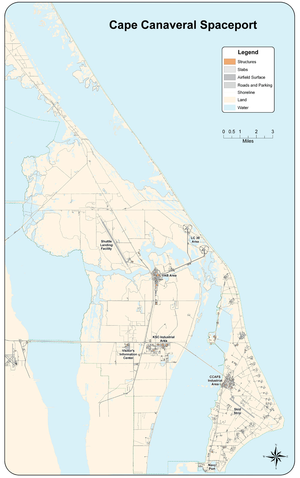
Known collectively as Cape Canaveral Spaceport, the launch pads, research buildings, educational facilities, and administrative offices on and around Cape Canaveral have sprawled to encompass many thousands of acres. Bill Sample, president of Spaceport's operations and maintenance provider, Space Gateway Support (SGS), says, "You essentially have a tremendous block of protected land on which NASA launches the space shuttle and the Air Force launches expendable, nonmanned launch vehicles." As the Joint Base Operations Support Contract (JBOSC) contractor, SGS is responsible for Spaceport facilities management, public works, engineering services, infrastructure/base support services, protective services, logistics, information technology, administrative services, medical services, and environmental services—essentially the management of a very specialized, technologically sophisticated city. The SGS contract is unique in Spaceport history, combining NASA and Air Force operations and maintenance into one contract for the first time, improving services, streamlining business practices, and keeping costs down.
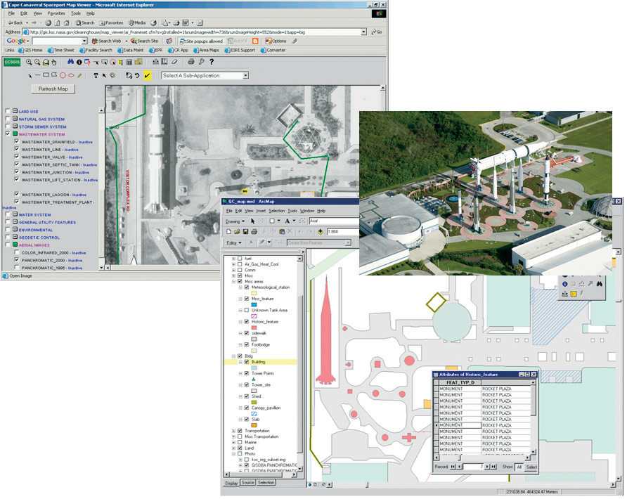
Implementation of a shared Cape Canaveral Spaceport GIS (CCSGIS) has brought these efforts one step further. "The system represents the partnering of two distinct federal agencies," says Sample. "It is the blending of their assets to more effectively achieve a common goal, while respecting NASA's scientific mission and the 45th Space Wing's national defense mission." Aimed at capturing, recording, displaying, and analyzing geographic information within the Spaceport community, CCSGIS is available only inside existing firewalls. Based on Esri software's compatibility with other GIS systems and databases, SGS built CCSGIS on an ArcView, ArcInfo, ArcSDE, and ArcIMS foundation. Taken as a whole, the enterprise system supports a framework of Web sites and specialized applications for functions ranging from environmental management to security calls to office allocation. "In 1998," says Sample, "we were challenged to develop a GIS within five years. And that's basically all the information we had to start the project. Within those years, we were able to build the system from the ground up." Implementing CCSGISA project management approach was used to develop the system, relying on a multidisciplinary team of GIS and information technology professionals, real property accountants, and community planners. Using an Oracle database tied to ArcGIS through ArcSDE, SGS created a GIS repository for the whole Cape Canaveral Spaceport, consolidating data from disparate sources and formats. "Most of the data was stored in hard copy and in CAD drawings," says Bill Stoeckel, Real Property Information Systems supervisor, SGS. "It was not in an intelligent environment—there was no other information associated with it. Implementing CCSGIS was a big step forward for our customers."
Data collection and processing proved to be a challenge. Aerial photography was used for feature extraction and as a backdrop for Web, ArcView, and ArcInfo applications. Aside from the photo feature extraction, pulling and consolidating other data for the Spaceport's facilities, pipelines, electrical systems, roads, and natural resources were the project's greatest hurdles. "Data was gathered on-site from existing sources or through actual field survey," says Stoeckel. "When the package was put together, the Real Property Accounting Office alone consolidated 13 different databases. We've seen data on the back of convenience store napkins and a lot of other things that just lacked substance." As the data was cleaned and assembled, SGS staff began to use CCSGIS as a launching pad for applications and specialized projects. With a vast range of services and responsibilities, the contractor's most unique challenges were tied tightly to the land itself. Preserving Natural Resources—148,000 Acres of Protected LandA relatively small area of the Cape Canaveral Spaceport is dedicated to launch operations. Of the approximately 157,000 acres that comprise the Spaceport, more than 90 percent (148,000 acres) are reserved for conservation and recreation. The Merritt Island National Wildlife Refuge and Cape Canaveral National Seashore dominate the area, with protected segments of the Banana and Indian Rivers fringing the Spaceport's outer borders.
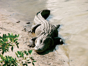
Consisting primarily of brackish estuaries and marshes, the protected land encompasses seven distinct habitat types and is an important wintering area for migratory birds. All told, there are more than 1,000 plant and animal species identified on the Spaceport, 89 of which are listed as threatened, endangered, or of special concern by state or federal agencies. Manatees, sea turtles, peregrine falcons, wood storks, and alligators are among the cape's residents. Sharing launch facilities and infrastructure with such natural resources is a difficult balancing act. CCSGIS forms a basis for successful preservation. Says Sample, "We have an awful lot of wildlife and other species that are resident and protected here. Using GIS, we have been able to link physical location and attributes with environmental data." To support Spaceport's infrastructure, SGS responsibilities include the management of wastewater and industrial wastewater treatment facilities, hazardous wastes, air pollution sources, landfills, regulated tank systems, and asbestos in addition to the construction of new facilities and rehabilitation of existing facilities. Therefore, every year SGS collects and analyzes more than 3,000 environmental samples as part of its compliance with more than 200 environmental permits.
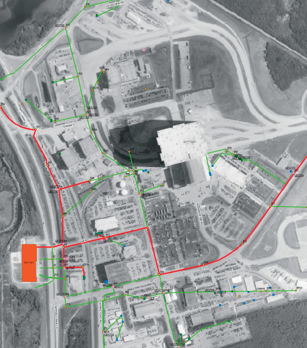
CCSGIS not only facilitates these processes with easily managed and accurate data but also improves decision making by providing detailed analysis and modeling capabilities. Since its creation, the system has been used to plot utility corridor alignments, plan new facilities, locate monitoring wells and regulated pollutant sources, and identify areas of critical habitat. ArcView and ArcInfo functionality has been used to identify gopher tortoise burrows and quickly assess potential impacts on this protected species from various utility corridor alignments. Additionally, when linked by ArcSDE to Oracle operational databases, locations of regulated fuel tanks and storm water management systems have facilitated fast analysis of new or pending regulatory requirements, as well as cost estimates to upgrade or modify existing systems. Supporting Human Resources—2,000 Employees and 25,000 CustomersWith the population and facilities of a small city, the Spaceport's operation and maintenance concerns extend beyond environmental management. As CCSGIS became firmly established, allowing employees throughout Cape Canaveral's support base to leverage GIS capabilities was a high priority. To this end, SGS built outward from the core functionality of CCSGIS, implementing a Web-based Spaceport Map Viewer available to all employees.
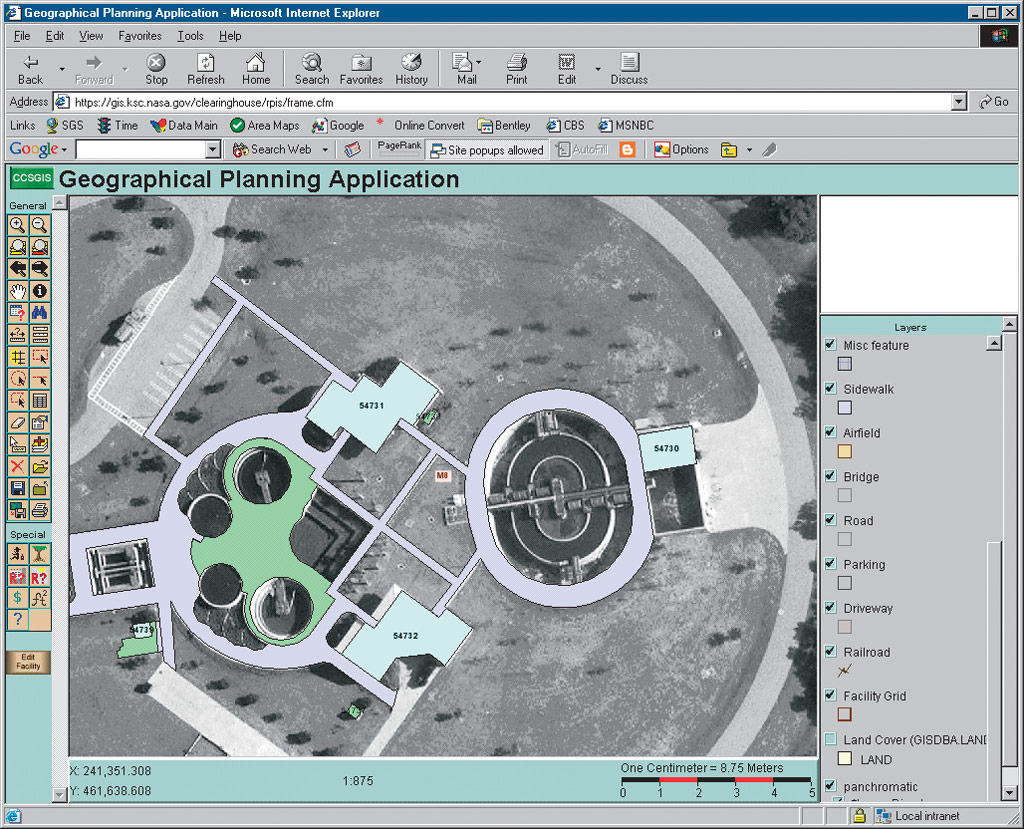
In addition to displaying planimetric, facility, and utility information, the Spaceport Map Viewer allows users to draw basic shapes and add text to maps. To achieve this functionality, Esri's ColdFusion (CF) Connector allows CF tags to display dynamic content from ArcSDE. All spatial data is contained within an Oracle database, and Adobe's Scalable Vector Graphics (SVG) viewer provides drawing and display capabilities. Image generation is triggered via a call to ArcSDE from the CF Connector and associated CF custom tags, with XML and XSL Transformations used to translate ArcXML to SVG–XML. A Java component lends quality control to the system, verifying that SVG-drawn shapes submitted to ArcSDE are valid polygons. The rich functionality of the Spaceport Map Viewer provided a jumping-off point for a number of specialized subapplications. Designed to meet the unique requirements of everyday users, these tools support functions from master planning to excavation permit mapping to security incident tracking. "With more than 2,000 people who work under the support contract and a base population of about 25,000," says Sample, "you can imagine we have a fair share of security incidents requiring our response." To manage and track these incidents effectively and reliably, SGS built a password-protected Spaceport Map Viewer subapplication to depict incident locations and facilitate geospatial analysis. Its simple-to-use interface allows Spaceport staff to investigate and display information related to security incidents such as traffic accidents, theft, and complaints.
Once the capabilities of the Spaceport Map Viewer became apparent, Spaceport employees began to make requests for specialized subapplications to meet their needs. "One of our community planning customers needed a tool to determine how many people populated groups of buildings and the current replacement values of the buildings," says Stoeckel. In response, SGS created a subapplication that buffers a selected area, executes a program that pulls up facility replacement values from one database while extracting building populations from another, and produces a tidy summary report. All together, 10 specialized Spaceport Map Viewer subapplications have been built and implemented, giving Spaceport employees access to the wide range of CCSGIS data and capabilities in a user-friendly format. However, the Spaceport Map Viewer base application and its progeny are supplemented by additional stand-alone CCSGIS applications addressing concerns such as geographic planning and 911 emergency response. "As a spin-off of the enterprise system, a secure stand-alone 911 application, Map-911, has been developed with a twofold purpose," says Stoeckel. "In addition to providing 911 operators with helpful information, such as nearby utilities or fire stations, the application can be deployed during contingency situations when the main system might not be available due to network or power outages." The strength and spectrum of services and capabilities provided under the CCSGIS umbrella continue to grow. Implementation of ArcFM (from Esri Business Partner Miner & Miner, Fort Collins, Colorado) is nearing completion for the Cape Canaveral Air Force Station. Data collection is complete, and the ArcFM model has been created and populated. Additionally, water models for both NASA and Air Force Spaceport components are well underway. Recent additions of ArcGIS 3D Analyst and ArcGIS Spatial Analyst to the SGS software base will provide this modeling with another boost in power and flexibility.
Future goals for more specialized functionality include a confined space hazard alert tool and vehicle tracking system. "We run roughly 6,000 work orders a month," says Sample. "That's everything from hanging a new light fixture to repairing carpet to tearing down a wall. It's important to know how we distribute our crews and where they are working. We are in the process of gathering requirements for tracking our vehicles with onboard GPS transmitters. This tool would benefit SGS teams beyond our maintenance group, enabling emergency and security commanders to view near real-time locations of their vehicles." By taking advantage of advanced software, CCSGIS continues to improve services and streamline processes, providing an accurate and usable single platform of facility information. Five years into the first joint operations and maintenance contract between Cape Canaveral's Air Force and NASA inhabitants, SGS' efforts are a vivid illustration of the power of data sharing and the potential of a robust enterprise GIS. "At the moment we have a 95 percent performance rating," says Sample. "That's a high report card—the experiment is working and our customers are very pleased." For more information, contact Samuel Gutierrez, Public Affairs, Space Gateway Support (tel.: 321-867-4067, e-mail: samuel.o.gutierrez@jbosc.ksc.nasa.gov). |
 For more than 40 years, the U.S. National Aeronautics and Space Administration (NASA) and the Air Force have shared Florida's Cape Canaveral, accomplishing the strange and awe-inspiring achievement of launching spacecraft from a wildlife refuge. Recently, managing such complexity has become decidedly simpler. Pooling their resources and data, NASA's John F. Kennedy Space Center and the 45th Space Wing's Cape Canaveral Air Force Station implemented a shared GIS.