Spring 2004
Spring 2004 |
|||||||
|
|
|||||||
New Image Storage Architecture Provides Turnkey Solutions |
|||
|
The GIS industry is experiencing a phenomenal increase in new data, and GIS customers are being tasked with a number of challenges. Supporting new data, providing Internet imaging services, retaining historical data to meet government regulations, and expanding enterprise GIS operations are just a few of these challenges. GIS customers are also dealing with rapidly growing data management complexity, reduced staff, and the expense and unreliability of optical and tape systems. From small map producers to commercial and Web routing businesses to national government agencies, GIS organizations are dealing with a number of large-scale data storage challenges and are being forced to examine how well these ever-increasing volumes of data are able to support their business operations. As image data steadily grows from gigabytes to terabytes to petabytes (several Esri customers are approaching more than a petabyte of spatial data), a significant change in storing, managing, accessing, and utilizing this data is now a necessity.
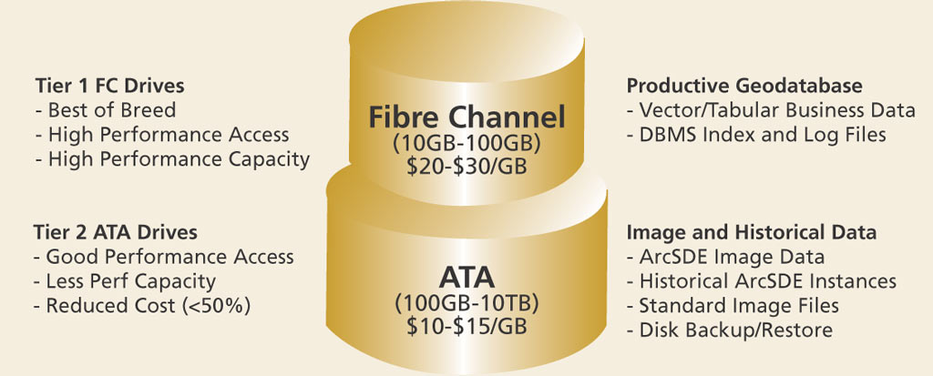
Esri has worked to evaluate available storage technology alternatives and identify viable storage strategies that address the growing need for online data access in the GIS community. As a result of this research, a unique cost-effective storage architecture—Image Storage Architecture (ISA)—was created to support large volumes of image and historical data in an enterprise GIS production environment. Image Storage ArchitectureISA is a complete online data storage solution designed to manage the growing cost of providing online geographic information services and improve the administration of massive online data repositories. It is preconfigured, pretested, and highly optimized for GIS environments. The ISA solution includes the storage hardware, necessary management software, and the services required for installation. ISA solutions were tested on the CLARiiON family of storage hardware and software from EMC, Hopkinton, Massachusetts. Designed to support a wide range of customer requirements, including file system and high-performance database implementations, ISA solutions can grow with the needs of the user. They are systems with features that include global hot spares (extra emaergency disks), redundant power and cooling, end-to-end integrity checking, and redundant array of independent disks (RAID), which means that data is stored on multiple magnetic or optical disk drives to increase output performance and storage capacities and to provide varying degrees of redundancy and fault tolerance protection. There is no single point of failure. What's Different About ISA?Fibre channel (FC) technology allows data to be transmitted and received at one gigabit per second simultaneously, delivering high service levels but at a greater cost, while advanced technology attached (ATA) disk drives are low in cost, high in density, and ideally suited for large, sequential data such as backup and GIS image data transactions. ISA provides an optimum mix of high-performance FC disk storage technology with high-capacity, lower cost ATA disk storage as a standard GIS production storage architecture. In ISA solutions, both disk technologies (FC and ATA) are integrated in a high-performance, highly available, fault-tolerant hardware RAID storage environment supported by best-of-breed storage management technology. ISA takes advantage of dramatic differences between GIS disk performance demands for vector and image data resources in supporting standard map display queries. A very large number of vector data queries are required to support a single map display, while a relatively small number of image queries support the same map display transaction. Vector and tabular data is supported on high-performance/capacity FC disk storage, while image and historical data is supported on higher density, lower cost ATA drive technology. The relatively high-capacity storage requirements for GIS image data result in a significant reduction in overall ISA storage costs. The primary ISA production environment is a two-tier architecture. A tray of standard FC high-performance/capacity disk drives supports the first tier. The second tier is supported by a variable number of trays with standard ATA high-capacity disk drives. The first storage tray supports the ArcSDE production geodatabase. This data includes both vector and tabular business tables and database index and log files. The first storage tray typically supports more than 2 TB of disk capacity (when using 146 GB drives), providing plenty of capacity to support Esri customer current period production geodatabase environments. The remaining storage trays are currently supported with 250 GB ATA drives used to support ArcSDE image data, historical online ArcSDE geodatabase instances, and standard image files. Index and log tables for this data can be supported on the FC tray for improved access performance. ISA disk storage solutions can support up to 16 trays in a single rack-mounted storage environment, supporting more than 57 TB of GIS data resources from a single high-performance disk controller. Several of these systems can be supported in an enterprise storage environment to support online storage of more than a petabyte of online image data resources. Image Storage Architecture PackagesEsri has configured several typical storage packages designed to meet the various requirements of GIS users. These packages are preintegrated, pretested turnkey solutions that support a "buy as you need" deployment strategy. And the modular architecture supports future expansion requirements, often contributing to more than 50 percent reduction in customer storage costs. These packages can be deployed to support a variety of customer production environments, ranging from an entry-level departmental package that supports up to 5 TB of total disk storage capacity to a high-level enterprise environment package that supports up to 57 TB of total disk storage capacity. These packages include
Information on these packages can be found at www.esri.com/hwpromo.html#emc. |