Spring 2004
Spring 2004 |
|||||||
|
|
|||||||
Developing Innovative GIS Solutions for More Than a Decade
Saudi Arabian Oil Company Explores the Advantages of Enterprise GIS |
|||||||
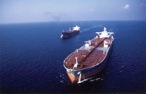
The Saudi Arabian Oil Company (Saudi Aramco) is the state-owned oil company of the Kingdom of Saudi Arabia. It ranks first among oil companies worldwide in terms of crude oil production and exports and is among the leading producers of natural gas. Saudi Arabia is the holder of the world's largest oil reserves—one-quarter—at more than 259 billion barrels. Saudi Aramco is a fully integrated oil company with operations in exploration, production, refining, marketing, and international shipping. In conjunction with its operations the company manages a colossal network of assets that includes wells, pipelines, plants and buildings, roads, utility networks, jet aircraft, and supertankers. Saudi Aramco also runs joint venture refining and sales operations in North America, Europe, and Asia. More than 50,000 employees perform a spectrum of jobs ranging from exploration geologists and geophysicists to engineers, project managers, environmental scientists, and deep desert surveyors. All of these jobs rely on technical information that is geographically based. Virtually all of Saudi Aramco's activities on land, air, and sea can be mapped to a physical location and analyzed in a GIS. Recognizing this, the Information Technology Division of Saudi Aramco has been developing innovative Esri software-based GIS solutions for more than a decade. These systems support the company's diverse mission and include Surveying and Exploration—ArcGIS Desktop (ArcEditor) is used extensively to plan seismic surveying missions, monitor the performance of contractor crews, and analyze geophysical data collected during the surveys.
Engineering—A custom Mapping Wizard lets staff access a wealth of spatial data from the Oracle–ArcSDE repository and quickly create publication-quality maps, without needing to know anything about GIS technology or cartography. Customized ArcGIS applications are used to support well site planning, wellhead maintenance, and other engineering functions. ArcPad software-based solutions are also being developed to support field-based navigation and data capture. Logistics—The company's existing telecommunications infrastructure is being leveraged to dispatch and track the movement of company cars, heavy trucks, and ocean-going supertankers. Knowing the precise location of vehicles and vessels is essential for the timely delivery of goods and services. It also provides a lifeline for staff driving in remote desert locations. Planning—ArcEditor is used to digitize the location of all new facilities, and the resultant information is reviewed online by planners and engineers using dynamic ArcIMS maps. ArcIMS has been integrated with a Web-based document management system to enhance decision making and reduce the project review time frame. Transportation—ArcGIS Desktop has been integrated with a third party road and pavement maintenance system, enabling transport engineers to visually assess road conditions over a large geographic area and forecast road works based on local traffic volumes. Such spatial insights are impossible to gain without GIS. Utilities/Asset Management—Major projects are underway to convert the company's power, wastewater, and telecommunication networks from a legacy AM/FM system to the third party solutions ArcFM and Network Engineer from Esri Business Partners Miner & Miner (Fort Collins, Colorado) and Telcordia (Morristown, New Jersey), respectively. This utility data is crucial for planning engineering works and will form an important pillar within the enterprise GIS. Interdepartmental data sharing agreements are helping to maximize the value of the company's spatial data holdings.
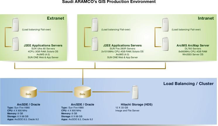
Safety and Emergency Response—Along with the vehicle and vessel tracking system, a Web-based gas leak emergency response system has been developed. This system reads live gas sensor readings and real-time weather information within the company's plants and graphically overlays this with important GIS layers such as digital aerial photos, buildings, roads, hospital locations, airports, and rescue facilities. Using dynamic maps, emergency responders gain a clear, shared picture of the emergency and its potential impact on people and facilities. Knowledge Sharing—An online mapping portal has been released on the company's Intranet. Developed in Java, the ArcIMS site enables staff to easily locate company facilities, dynamically generate routes and driving instructions, and share annotated maps with colleagues via e-mail. Land Management—Saudi Aramco relies heavily on GIS to manage land use permitting processes, research land claims, and monitor illegal encroachment within the company's thousands of square kilometers of concession area. The feasibility of using satellite imagery to automatically detect and map land use changes over time is currently being investigated. Saudi Aramco hardware infrastructure is configured to be fault tolerant with a load balancing option enabled solely to ensure 24/7 availability with optimal performance of these mission critical applications. All corporate GIS data is stored in an Oracle9 database running ArcSDE 8.3 on a UNIX clustered server. ArcIMS is used to serve Web-based image maps across the company.
The foundation for a true enterprise GIS is now in place. Looking ahead, major GIS initiatives for 2004 include the ability to
For more information, contact emap@aramco.com. |