Spring 2004
Spring 2004 |
|||||||
|
|
|||||||
Sunny Isles Beach, Florida, Puts Itself on the Map |
|||||
The city of Sunny Isles Beach is a coastal community stretching 2.5 miles along the east coast of Florida, just north of Miami Beach. The city is on a narrow stretch of land between the Atlantic Ocean and the Intracoastal Waterway. Because of the rapid growth of the south Florida area—15,000 permanent residents plus 1,000,000 annual vacationers—the city recently began proactively planning a new phase of redevelopment and a facelift for the city. Older low- and mid-rise motels are being replaced by high-rise condominiums 30 to 50 stories high; new roadways and municipal facilities are being designed and built. With all this ongoing and anticipated activity, the city wanted to visualize the influence this growth would have on the existing infrastructure. The Planning Department faced challenges as it attempted to acquire mapping data. Incorporated in 1997, and inheriting worn, hand drawn maps from Miami-Dade County, the city needed to bring its mapping and map-related information into the 21st century. Challenges included GIS data centralization, data manipulation, and data accessibility. For example, map-related data on the Web site was presented in a static format. A solution was needed that would move the city from a static view to a more dynamic model in which rapidly changing information could be readily accessible. City staff needed increased flexibility in an environment that would allow them to manipulate the data on their desktops. When the shortcomings of the current situation came to light, Esri Business Partner Calvin, Giordano and Associates, Inc. (CGA), an engineering, planning, and surveying consulting firm, was in its first weeks of providing planning services to the city. The planning services evolved to include GIS services. CGA's Data Technologies and Development Department (Data Tech Team) was already providing similar GIS services to other south Florida municipalities, so this was familiar ground for them. The ProcessThe Data Tech Team demonstrated the value of GIS to the city, which quickly grasped the positive impact GIS would have on residents and municipal management activities. The city immediately accepted the GIS solution and kicked off a new chapter in its redevelopment process. The first step was creating a parcel basemap from scratch and developing three data sets (land use, future land use, and zoning) for the planners. The parcel basemap was spearheaded by CGA's Survey Department using coordinate geometry and traditional surveying methodology. Weeks were spent at the Miami-Dade County Records Division researching documentation to create the parcel boundary delineation as it exists today. The Survey Department painstakingly entered each recorded plat as well as metes and bounds descriptions for all parcels. The parcel basemap was imported into ArcSDE, and additional data sets were created using the parcel basemap as the foundation. Utilizing Esri software for more than six years, the Data Tech Team knew it had the software it needed to successfully deliver the project from beginning to end. The latest in Esri software—ArcGIS, ArcSDE, and ArcIMS—is used for all GIS-related projects by the Data Tech Team. The city also realized the value of having this data available to residents and decided to deploy the data via the Internet. Alyce Hanson, the city's Administrative Services director, states, "It was important to city staff that the GIS Web site application be usable by casual Web site visitors-that we present data in terms that made sense to them. For example, we wanted residents living in the single-family area of Golden Shores to easily access the interactive maps and find the closest stop of the free, city-run community shuttle. We also provided the scheduled times for that stop." With this in mind, CGA developed data sets for bookmobiles; school boundaries; beach access; crosswalks; parks; bus benches; community shuttle stops and schedules; cable, electric, natural gas, potable water, and sewer companies; the city; the county; the state house and senate; and congressional districts. The long-term goal for this project is to not bombard residents and vacationers with too much information but rather to develop an intuitive and user-friendly interface through ArcIMS. Miami-Dade County Online Services staff, who were involved in the development and deployment of the official city Web site (www.sibfl.net), took part in the design and put forth usability recommendations based on best practices in e-government. The new GIS Web site is accessed through a link on the official city Web site home page. The SolutionCGA built a fully customizable solution to deploy the city's GIS and non-GIS data over the Web, based on ArcIMS, ArcSDE, Active Server Pages (ASP), ASP .NET, JavaScript, and SQL Server 2000. The selected hardware guarantees 99.9 percent uptime for the development environment (staging servers) and for production (Web server and database server), which includes a full backup strategy and versioning control at the data and software levels. ArcSDE facilitates spatial and nonspatial data management providing a central repository. This makes the system reliable for monthly updates and assures accuracy of the information being accessed.
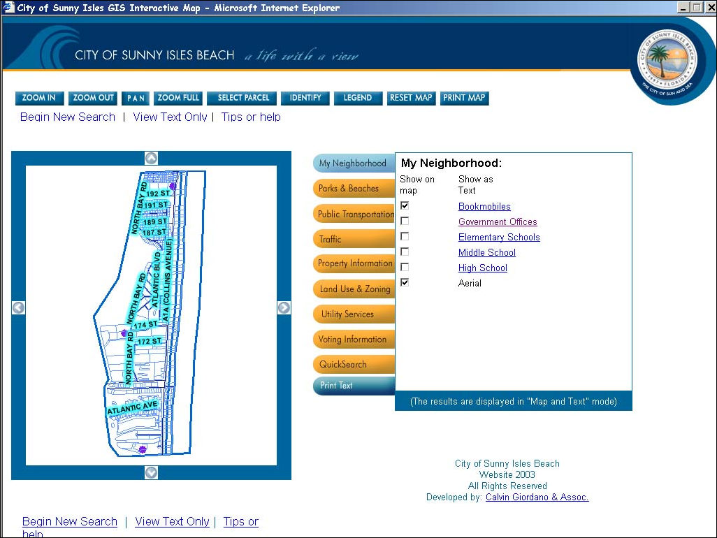
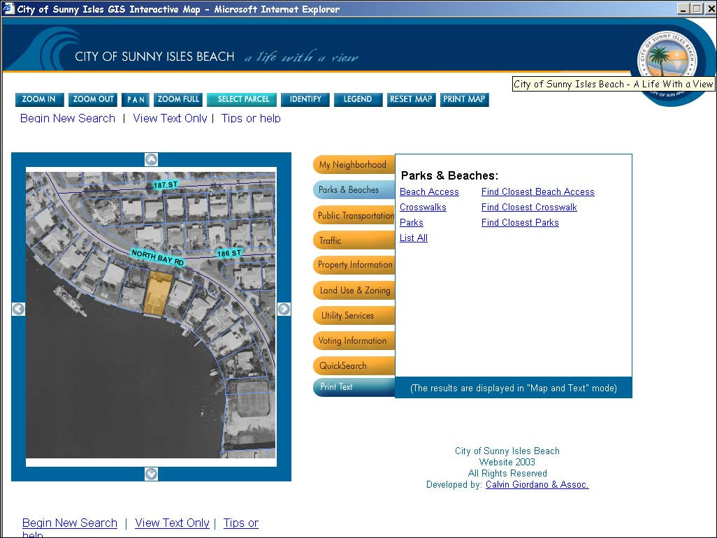
CGA combined the power of ArcIMS, ArcSDE, and Web development to classify and present the information for all users including non-GIS users. The geographic map interface includes buttons to zoom, pan, select, identify, and print a map at any point. After a parcel is selected, the system displays data in a text frame showing only information pertaining to the selected record. The application utilizes tabs (i.e., categories) to present information in a very intuitive manner. The tabs approach displays information grouped by My Neighborhood, Parks and Beaches, Public Information, Property Information, Land Use and Zoning, Traffic, Utility Services, Voting Information, or Quick Search. The Quick Search tab offers another way for users to quickly find information. As another option, a text only version was developed, taking into consideration dial-up connections and providing the same functionality and information but without displaying it graphically on a map. When entering the Web application, the user chooses a controlled query or an entire city search. The user can type a complete or partial address, folio, or owner's last name. Then, from the built-in paging mechanism, the user can select from a drill-down list and browse information classified in the tabs. One feature embedded in the application allows the user to find within milliseconds the closest points (bookmobiles or beach access, for example) from any parcel, taking full advantage of data in the SQL Server and calculating the distance using a mathematical formula utilizing the x,y coordinates of all features in the query. The Data Tech Team delivered a complete application solution to the city by creating the parcel basemap from scratch, along with additional data sets, and carrying it through implementation, deployment, and hosting. The GIS Web site is hosted and maintained at CGA, which significantly offsets the city's costs. The city staff directing this project and the Data Tech Team never wandered from the intention of the original goal: Always stay focused on end user capabilities, and provide an intuitive user-friendly interface for city staff and the general public. Others benefiting from the information are commercial and real estate brokers/agents and potential property owners. For more information, contact Alyce Hanson, Sunny Isles Beach (e-mail: ahanson@sibfl.net); Hector Perez, CGS (e-mail: hperez@calvin-giordano.com); or David Pineda, CGS (e-mail: dpineda@calvin-giordano.com). |