|
ArcGIS Schematics allows ArcGIS users to generate, visualize, and manipulate diagrams from their data.
| |
ArcGIS Schematics allows users to dynamically interact with and efficiently check the connectivity of any network. |
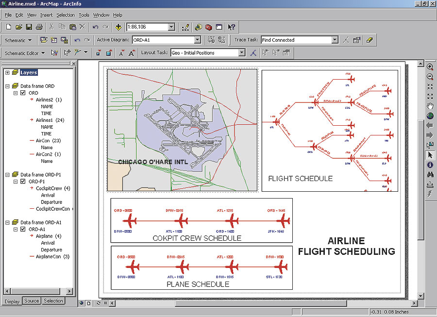
ArcGIS Schematics provides the tools to operate, manage, and view data from almost any geometric network or tabular format with "from" and "to" connectivity in a wide variety of geographic and schematic representations. ArcGIS Schematics automates the generation of schematic diagrams from geographic and nonspatial data, and changes to the data are reflected in the schematic diagrams.
At ArcGIS 9.1, the ArcGIS Schematics extension is tightly integrated into ArcGIS applications. Users can use the ArcGIS standard tools to navigate both their schematics and maps and integrate both on a single map output. Schematics are now stored and managed in the geodatabase, allowing users to better share and edit their diagrams within their organization.
Key ArcGIS Schematics features are
- On-the-fly diagram generation—Generate diagrams automatically from a selection set or tracing result, limiting the number of operations and saving time.
- Logical and physical representation—Display the logical connectivity of services in addition to the physical representation of the network.
- Interaction between the geographic data view and the schematic view—Dynamically interact with the geographic data view (distinguishing topological relationships) and the schematic view (displaying the network architecture).
- Query-based diagrams—Display diagrams based on data that does not participate in a geometric network but has a way to identify the connectivity between objects. This is ideal for such applications as animal tracking and supply chain management. It can also be used for inside plant scenarios in which users need to see the internal structure of a plant that is not digitized in their geodatabase.
- Node reduction—Graphically remove selected nodes and reconnect incident links with a superspan (e.g., for an electric network, poles can be removed to display active network features only).
- Connection to multiple data sources—Manage both spatial and nonspatial data and interact with a geodatabase or other network-related databases within a single session.
- Overlapping link separation algorithm—Separate selected lines connected to the same junction.
- Custom symbol alignment—Specify an angle to automatically arrange symbols along an imaginary axis.
New features for ArcGIS 9.1 Schematics include
- Diagrams are displayed as a layer in ArcMap to simplify the user interface and the printing of diagrams. This also allows a user to place a diagram on top of basemap layers if desired.
- Undo/Redo functionality allows users to undo or redo changes made to a diagram.
- Consolidated tools and toolbars simplify the user interface.
- All information is stored and managed in a geodatabase for ease of integration, editing, and access by multiple users.
ArcGIS 9.1 Schematics is delivered with the ArcGIS Desktop installation CD. Users can evaluate ArcGIS Schematics directly from their ArcGIS Desktop (ArcInfo, ArcEditor, ArcView) product. For more information, visit www.esri.com/schematics, call Esri at 1-800-447-9778, or call your Esri regional office. Outside the United States, contact your local Esri distributor.
|